Property Record
4210 N Roxboro St, Durham, NC 27704
NEARBY LISTINGS FOR SALE OR LEASE
Property Detail
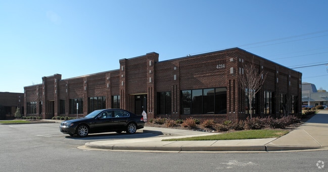
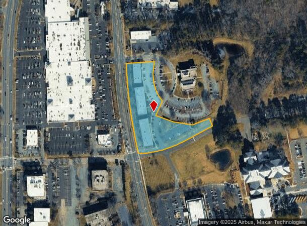
4210 N Roxboro St
Durham-Chapel Hill, NC
Roxboro Rd Prof Ctr Cd/B2
196374
ROXBORO RD PROFESSIONAL C ENTER CONDO/COMMON AREA PL:CD0008-000343
Residentialacreage
Durham
X
North Carolina
3720082300K
3
0
3.05 AC
2025
North Durham
001709
Raleigh/Durham
DEMOGRAPHICS near 4210 N Roxboro St
1 Mile
3 Mile
5 Mile
2024 Total Population
8,978
58,098
140,537
2029 Population
9,362
60,453
146,730
Pop Growth 2024-2029
+ 4.28%
+ 4.05%
+ 4.41%
Average Age
39
39
38
2024 Total Households
3,488
24,209
57,074
HH Growth 2024-2029
+ 4.33%
+ 4.22%
+ 4.79%
Median Household Inc
$47,400
$63,556
$57,911
Avg Household Size
2.40
2.30
2.30
2024 Avg HH Vehicles
2.00
2.00
2.00
Median Home Value
$216,212
$275,085
$286,225
Median Year Built
1988
1981
1981
Nearby Places
Map Layers
Map Styles
 Street
 Aerial
- Restaurants
- Banks
- Shops
- Fitness
- Groceries
PUBLIC TRANSPORTATION
COMMUTER RAIL
Durham Amtrak Station (Carolinian - Amtrak, Piedmont - Amtrak)
DRIVE
WALK
Distance
Durham Amtrak Station (Carolinian - Amtrak, Piedmont - Amtrak)
10 min
3.9 mi
AIRPORT
Raleigh-Durham International
DRIVE
WALK
Distance
Raleigh-Durham International
28 min
16.2 mi
Freight Ports
Virginia Port Authority - Richmond
DRIVE
WALK
Distance
Virginia Port Authority - Richmond
170 min
147.1 mi
Nearby Properties
Address
Land Use
TOTAL SIZE
Lot Size
Zoning
Address
Land Use
TOTAL SIZE
Lot Size
Zoning
749,544 SF
100.49 AC
OI,RS-8
Address
Land Use
TOTAL SIZE
Lot Size
Zoning
758,666 SF
99.64 AC
PDR 2.000
Address
Land Use
TOTAL SIZE
Lot Size
Zoning
24,741 SF
5.67 AC
CD-S1
Address
Land Use
TOTAL SIZE
Lot Size
Zoning
3.20 AC
CD-S1
Address
Land Use
TOTAL SIZE
Lot Size
Zoning
12,440 SF
36.51 AC
PDR 2.000
Address
Land Use
TOTAL SIZE
Lot Size
Zoning
368,569 SF
2.77 AC
Address
Land Use
TOTAL SIZE
Lot Size
Zoning
485,295 SF
27.35 AC
RS-8
Address
Land Use
TOTAL SIZE
Lot Size
Zoning
69.37 AC
IL
Address
Land Use
TOTAL SIZE
Lot Size
Zoning
6,753 SF
22.99 AC
OI(D)
Address
Land Use
TOTAL SIZE
Lot Size
Zoning
166,866 SF
76.52 AC
RS-10
Address
Land Use
TOTAL SIZE
Lot Size
Zoning
297,910 SF
39.63 AC
RS-20
Address
Land Use
TOTAL SIZE
Lot Size
Zoning
12,468 SF
13.33 AC
RU-M(D)
Address
Land Use
TOTAL SIZE
Lot Size
Zoning
97.24 AC
UC(D)
Address
Land Use
TOTAL SIZE
Lot Size
Zoning
6,822 SF
24.64 AC
PDR 2.000
Address
Land Use
TOTAL SIZE
Lot Size
Zoning
354,480 SF
34.53 AC
IL
Address
Land Use
TOTAL SIZE
Lot Size
Zoning
4,644 SF
19.04 AC
RU-M
Address
Land Use
TOTAL SIZE
Lot Size
Zoning
15,720 SF
16.18 AC
PDR 10.000
Address
Land Use
TOTAL SIZE
Lot Size
Zoning
19,769 SF
9.12 AC
OI(D)
Address
Land Use
TOTAL SIZE
Lot Size
Zoning
7,056 SF
25.68 AC
RS-M
Address
Land Use
TOTAL SIZE
Lot Size
Zoning
6,936 SF
11.42 AC
PDR 2.000
Address
Land Use
TOTAL SIZE
Lot Size
Zoning
176,751 SF
17.77 AC
OI
Address
Land Use
TOTAL SIZE
Lot Size
Zoning
8,824 SF
15.96 AC
RS-M
Address
Land Use
TOTAL SIZE
Lot Size
Zoning
15,140 SF
19.79 AC
RS-M
Address
Land Use
TOTAL SIZE
Lot Size
Zoning
3.80 AC
PDR 7.200
Address
Land Use
TOTAL SIZE
Lot Size
Zoning
22,368 SF
20.40 AC
PDR 4.990
Address
Land Use
TOTAL SIZE
Lot Size
Zoning
135,246 SF
17.10 AC
CG(D)
Address
Land Use
TOTAL SIZE
Lot Size
Zoning
98,638 SF
24.59 AC
IL
Address
Land Use
TOTAL SIZE
Lot Size
Zoning
139,368 SF
5.70 AC
RU-M
Address
Land Use
TOTAL SIZE
Lot Size
Zoning
17,088 SF
15.96 AC
PDR 10.000
Address
Land Use
TOTAL SIZE
Lot Size
Zoning
8,400 SF
16.52 AC
RS-M(D)
The World's #1 Commercial Real Estate Marketplace
Connect with us
© 2026 CoStar Group
The information above has been obtained from sources believed reliable. While we do not doubt its accuracy we have not verified it and make no guarantee, warranty or representation about it. It is your responsibility to independently confirm its accuracy and completeness. Any projections, opinions, assumptions, or estimates used are for example only and do not represent the current or future performance of the property. The value of this transaction to you depends on tax and other factors which should be evaluated by your tax, financial, and legal advisors. You and your advisors should conduct a careful, independent investigation of the property to determine to your satisfaction the suitability of the property for your needs.