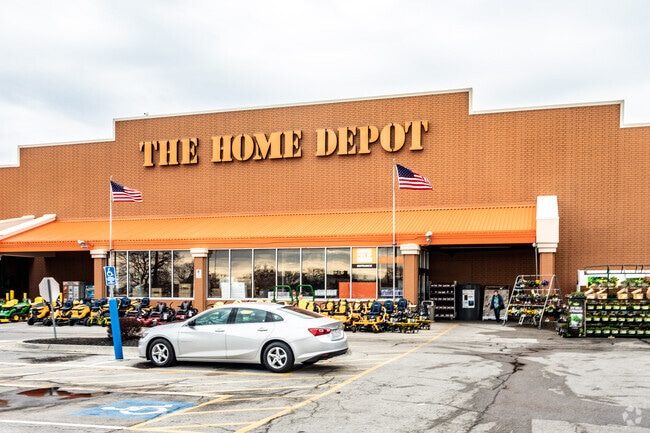
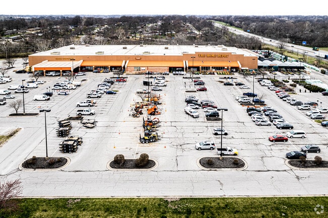
Property Record
4210 S Lees Summit Rd, Independence, MO 64055

Property Detail
4210 S Lees Summit Rd
33-140-11-20-00-0-00-000
SEC-24 TWP-49 RNG-32 PT OF SE 1/4 OF SE 1/4 DAF: BEG 1270.93 W & 245.07 N OF SE COR OF SE 1/4 TH CONT N 757.39 TH E 4 88.36 TH S 73 DEG E 271.7 TH S 381.98 TH W 55 MOL TH S 1
Storebuilding
Jackson
AE The base floodplain where base flood elevations are provided. AE Zones are now used on new format FIRMs instead of A1-A30 Zones.
Missouri
2024
12.61 AC
2025
East Jackson County
014501
Kansas City
111,120 SF
Kansas City, MO-KS
NEARBY LISTINGS FOR SALE OR LEASE
DEMOGRAPHICS near 4210 S Lees Summit Rd
1 mile
3 mile
5 mile
2025 Total Population
9,074
61,055
149,103
2030 Population
9,019
60,910
149,623
Pop Growth 2025-2030
(0.61%)
(0.24%)
+ 0.35%
Average Age
43
43
42
2025 Total Households
3,904
26,226
61,774
HH Growth 2025-2030
(0.54%)
(0.24%)
+ 0.33%
Median Household Inc
$68,126
$67,688
$66,608
Avg Household Size
2.30
2.30
2.30
2025 Avg HH Vehicles
2.00
2.00
2.00
Median Home Value
$210,815
$197,525
$198,906
Median Year Built
1971
1974
1971
Nearby Places
Map Layers
Map Styles
 Street
 Aerial
Layers
 Traffic
 Biking
Places
Listings with unknown addresses are not visible on the map
- Restaurants
- Banks
- Shops
- Fitness
- Groceries
PUBLIC TRANSPORTATION
COMMUTER RAIL
Drive
Walk
Distance
12 min
6.0 mi
AIRPORT
Kansas City International
Drive
Walk
Distance
Kansas City International
45 min
32.5 mi
Nearby Properties
Address
Land Use
TOTAL SIZE
Lot Size
Zoning
Address
Land Use
TOTAL SIZE
Lot Size
Zoning
398,212 SF
73.80 AC
Address
Land Use
TOTAL SIZE
Lot Size
Zoning
519,315 SF
28.47 AC
Address
Land Use
TOTAL SIZE
Lot Size
Zoning
158,369 SF
47.47 AC
Address
Land Use
TOTAL SIZE
Lot Size
Zoning
100,724 SF
1.65 AC
Address
Land Use
TOTAL SIZE
Lot Size
Zoning
455,100 SF
42.02 AC
Address
Land Use
TOTAL SIZE
Lot Size
Zoning
385,487 SF
5.61 AC
Address
Land Use
TOTAL SIZE
Lot Size
Zoning
338,731 SF
29.59 AC
Address
Land Use
TOTAL SIZE
Lot Size
Zoning
171,513 SF
18.37 AC
Address
Land Use
TOTAL SIZE
Lot Size
Zoning
64,318 SF
32.40 AC
Address
Land Use
TOTAL SIZE
Lot Size
Zoning
96,348 SF
14.42 AC
Address
Land Use
TOTAL SIZE
Lot Size
Zoning
94,411 SF
4.99 AC
Address
Land Use
TOTAL SIZE
Lot Size
Zoning
39,638 SF
Address
Land Use
TOTAL SIZE
Lot Size
Zoning
179,962 SF
16.02 AC
Address
Land Use
TOTAL SIZE
Lot Size
Zoning
31,674 SF
11.45 AC
Address
Land Use
TOTAL SIZE
Lot Size
Zoning
61,901 SF
15.11 AC
Address
Land Use
TOTAL SIZE
Lot Size
Zoning
210,008 SF
16.89 AC
Address
Land Use
TOTAL SIZE
Lot Size
Zoning
36,396 SF
8.64 AC
Address
Land Use
TOTAL SIZE
Lot Size
Zoning
75,028 SF
16.11 AC
Address
Land Use
TOTAL SIZE
Lot Size
Zoning
67,820 SF
11.94 AC
Address
Land Use
TOTAL SIZE
Lot Size
Zoning
20.97 AC
Address
Land Use
TOTAL SIZE
Lot Size
Zoning
178,652 SF
15.07 AC
Address
Land Use
TOTAL SIZE
Lot Size
Zoning
113,696 SF
28.25 AC
Address
Land Use
TOTAL SIZE
Lot Size
Zoning
68,921 SF
18.04 AC
Address
Land Use
TOTAL SIZE
Lot Size
Zoning
148,044 SF
17.85 AC
Address
Land Use
TOTAL SIZE
Lot Size
Zoning
157,429 SF
36.60 AC
Address
Land Use
TOTAL SIZE
Lot Size
Zoning
33,558 SF
2.74 AC
Address
Land Use
TOTAL SIZE
Lot Size
Zoning
137,992 SF
12.50 AC
Address
Land Use
TOTAL SIZE
Lot Size
Zoning
Address
Land Use
TOTAL SIZE
Lot Size
Zoning
147,000 SF
Address
Land Use
TOTAL SIZE
Lot Size
Zoning
48,664 SF
8.44 AC
The World's #1 Commercial Real Estate Marketplace
Connect with us
© 2026 CoStar Group
The information above has been obtained from sources believed reliable. While we do not doubt its accuracy we have not verified it and make no guarantee, warranty or representation about it. It is your responsibility to independently confirm its accuracy and completeness. Any projections, opinions, assumptions, or estimates used are for example only and do not represent the current or future performance of the property. The value of this transaction to you depends on tax and other factors which should be evaluated by your tax, financial, and legal advisors. You and your advisors should conduct a careful, independent investigation of the property to determine to your satisfaction the suitability of the property for your needs.