Property Record
S Phillips Rd, Lanett, AL 36863
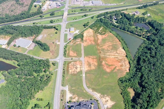
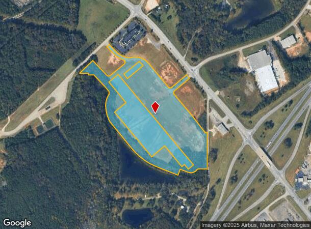

This Property Is For Sale
NEARBY LISTINGS FOR SALE OR LEASE
Property Detail
S Phillips Rd
17-02-10-0-001-015.013
BEG 1422'(S) N OF & 32'(S) W OF SE COR OF SE1/4 & ON W MARGIN OF 46TH STREET S.W., RUN W'LY110.57', SW'LY149.18', NW'LY111.93
Agriculturalland
Chambers
X
Alabama
01017C0280C
21.40 AC
2025
Chambers County
2024
Columbus GA
954800
Valley, AL
DEMOGRAPHICS near S Phillips Rd
1 Mile
3 Mile
5 Mile
2024 Total Population
333
13,124
25,526
2029 Population
322
12,709
25,218
Pop Growth 2024-2029
(3.30%)
(3.16%)
(1.21%)
Average Age
42
41
41
2024 Total Households
133
5,481
10,290
HH Growth 2024-2029
(3.01%)
(3.01%)
(1.09%)
Median Household Inc
$68,999
$45,837
$48,340
Avg Household Size
2.50
2.30
2.40
2024 Avg HH Vehicles
3.00
2.00
2.00
Median Home Value
$143,478
$103,736
$122,626
Median Year Built
1977
1974
1974
Nearby Places
Map Layers
Map Styles
 Street
 Aerial
- Restaurants
- Banks
- Shops
- Fitness
- Groceries
PUBLIC TRANSPORTATION
AIRPORT
Columbus
DRIVE
WALK
Distance
Columbus
52 min
38.9 mi
Freight Ports
Port of Panama City
DRIVE
WALK
Distance
Port of Panama City
277 min
212.7 mi
Nearby Properties
Address
Land Use
TOTAL SIZE
Lot Size
Zoning
Address
Land Use
TOTAL SIZE
Lot Size
Zoning
23,004 SF
38.40 AC
Address
Land Use
TOTAL SIZE
Lot Size
Zoning
13,920 SF
58.66 AC
Address
Land Use
TOTAL SIZE
Lot Size
Zoning
375,360 SF
20.30 AC
Address
Land Use
TOTAL SIZE
Lot Size
Zoning
9,750 SF
236.40 AC
Address
Land Use
TOTAL SIZE
Lot Size
Zoning
6,990 SF
15.99 AC
Address
Land Use
TOTAL SIZE
Lot Size
Zoning
28,768 SF
9.40 AC
Address
Land Use
TOTAL SIZE
Lot Size
Zoning
64.60 AC
Address
Land Use
TOTAL SIZE
Lot Size
Zoning
507,508 SF
110 AC
Address
Land Use
TOTAL SIZE
Lot Size
Zoning
146,616 SF
9.10 AC
Address
Land Use
TOTAL SIZE
Lot Size
Zoning
7,872 SF
8.41 AC
Address
Land Use
TOTAL SIZE
Lot Size
Zoning
72,300 SF
2.77 AC
Address
Land Use
TOTAL SIZE
Lot Size
Zoning
8,264 SF
7.88 AC
Address
Land Use
TOTAL SIZE
Lot Size
Zoning
25,588 SF
28.85 AC
Address
Land Use
TOTAL SIZE
Lot Size
Zoning
1 SF
6.90 AC
Address
Land Use
TOTAL SIZE
Lot Size
Zoning
113,361 SF
8.31 AC
Address
Land Use
TOTAL SIZE
Lot Size
Zoning
3,360 SF
3.50 AC
Address
Land Use
TOTAL SIZE
Lot Size
Zoning
60,534 SF
5.94 AC
Address
Land Use
TOTAL SIZE
Lot Size
Zoning
26,345 SF
17.60 AC
Address
Land Use
TOTAL SIZE
Lot Size
Zoning
43,794 SF
3.11 AC
Address
Land Use
TOTAL SIZE
Lot Size
Zoning
1 SF
13 AC
Address
Land Use
TOTAL SIZE
Lot Size
Zoning
32,997 SF
1.88 AC
Address
Land Use
TOTAL SIZE
Lot Size
Zoning
52,000 SF
1.01 AC
Address
Land Use
TOTAL SIZE
Lot Size
Zoning
1 SF
16 AC
Address
Land Use
TOTAL SIZE
Lot Size
Zoning
8,000 SF
18.60 AC
Address
Land Use
TOTAL SIZE
Lot Size
Zoning
15,762 SF
7.23 AC
Address
Land Use
TOTAL SIZE
Lot Size
Zoning
7,072 SF
2.69 AC
Address
Land Use
TOTAL SIZE
Lot Size
Zoning
1 SF
10 AC
Address
Land Use
TOTAL SIZE
Lot Size
Zoning
28,000 SF
4.05 AC
Address
Land Use
TOTAL SIZE
Lot Size
Zoning
15.20 AC
Address
Land Use
TOTAL SIZE
Lot Size
Zoning
1,504 SF
5.40 AC
The World's #1 Commercial Real Estate Marketplace
Connect with us
© 2025 CoStar Group
The information above has been obtained from sources believed reliable. While we do not doubt its accuracy we have not verified it and make no guarantee, warranty or representation about it. It is your responsibility to independently confirm its accuracy and completeness. Any projections, opinions, assumptions, or estimates used are for example only and do not represent the current or future performance of the property. The value of this transaction to you depends on tax and other factors which should be evaluated by your tax, financial, and legal advisors. You and your advisors should conduct a careful, independent investigation of the property to determine to your satisfaction the suitability of the property for your needs.