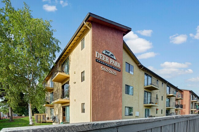
Property Record
4211 Laurel St, Anchorage, AK 99508

NEARBY LISTINGS FOR SALE OR LEASE
-
-
View all Anchorage listings for sale on LoopNet.com
Property Detail
4211 Laurel St
00803356000
T13N R3W SEC 28 TR 26 NW PTN
Apartment
Anchorage
X
Alaska
0200050762D
0.56 AC
2024
University Area
2025
Anchorage
001802
Anchorage, AK
15,408 SF
DEMOGRAPHICS near 4211 Laurel St
1 Mile
3 Mile
5 Mile
2024 Total Population
11,378
99,417
208,882
2029 Population
11,274
98,175
206,120
Pop Growth 2024-2029
(0.91%)
(1.25%)
(1.32%)
Average Age
38
38
37
2024 Total Households
4,475
39,605
80,529
HH Growth 2024-2029
(0.80%)
(1.26%)
(1.38%)
Median Household Inc
$78,979
$75,579
$79,336
Avg Household Size
2.30
2.30
2.40
2024 Avg HH Vehicles
2.00
2.00
2.00
Median Home Value
$306,271
$290,105
$316,336
Median Year Built
1977
1978
1980
Nearby Places
Map Layers
Map Styles
 Street
 Aerial
- Restaurants
- Banks
- Shops
- Fitness
- Groceries
PUBLIC TRANSPORTATION
AIRPORT
Merrill Field
DRIVE
WALK
Distance
Merrill Field
7 min
2.9 mi
Ted Stevens Anchorage International
DRIVE
WALK
Distance
Ted Stevens Anchorage International
11 min
5.9 mi
Freight Ports
Port of Anchorage
DRIVE
WALK
Distance
Port of Anchorage
13 min
5.9 mi
Nearby Properties
Address
Land Use
TOTAL SIZE
Lot Size
Zoning
Address
Land Use
TOTAL SIZE
Lot Size
Zoning
658,690 SF
70.86 AC
PLI
Address
Land Use
TOTAL SIZE
Lot Size
Zoning
22,362 SF
71.05 AC
PLI
Address
Land Use
TOTAL SIZE
Lot Size
Zoning
380,635 SF
10.82 AC
B3
Address
Land Use
TOTAL SIZE
Lot Size
Zoning
14,009 SF
24.86 AC
PLI
Address
Land Use
TOTAL SIZE
Lot Size
Zoning
160,830 SF
41.64 AC
PLI
Address
Land Use
TOTAL SIZE
Lot Size
Zoning
127,232 SF
4.55 AC
B2B
Address
Land Use
TOTAL SIZE
Lot Size
Zoning
171,692 SF
23.09 AC
I1
Address
Land Use
TOTAL SIZE
Lot Size
Zoning
33,906 SF
40 AC
PLI
Address
Land Use
TOTAL SIZE
Lot Size
Zoning
117,702 SF
9.85 AC
B3SL
Address
Land Use
TOTAL SIZE
Lot Size
Zoning
134,626 SF
16.91 AC
PLI
Address
Land Use
TOTAL SIZE
Lot Size
Zoning
381,477 SF
33.30 AC
B3
Address
Land Use
TOTAL SIZE
Lot Size
Zoning
195,079 SF
44.79 AC
PLI
Address
Land Use
TOTAL SIZE
Lot Size
Zoning
181,000 SF
7.54 AC
PLI
Address
Land Use
TOTAL SIZE
Lot Size
Zoning
61,127 SF
3.04 AC
B3
Address
Land Use
TOTAL SIZE
Lot Size
Zoning
179,543 SF
26.03 AC
PLI
Address
Land Use
TOTAL SIZE
Lot Size
Zoning
41,034 SF
6.28 AC
B3
Address
Land Use
TOTAL SIZE
Lot Size
Zoning
121,359 SF
4.35 AC
B3SL
Address
Land Use
TOTAL SIZE
Lot Size
Zoning
120,000 SF
9.09 AC
PLI
Address
Land Use
TOTAL SIZE
Lot Size
Zoning
104,412 SF
2.79 AC
B3SL
Address
Land Use
TOTAL SIZE
Lot Size
Zoning
124,058 SF
18.15 AC
B3
Address
Land Use
TOTAL SIZE
Lot Size
Zoning
133,758 SF
2.36 AC
ROSL
Address
Land Use
TOTAL SIZE
Lot Size
Zoning
56,747 SF
6.89 AC
B3SL
Address
Land Use
TOTAL SIZE
Lot Size
Zoning
64,695 SF
13.66 AC
PLI
Address
Land Use
TOTAL SIZE
Lot Size
Zoning
66,354 SF
44.23 AC
I2
Address
Land Use
TOTAL SIZE
Lot Size
Zoning
320,366 SF
36.42 AC
PLI
Address
Land Use
TOTAL SIZE
Lot Size
Zoning
242,189 SF
21.83 AC
I2
Address
Land Use
TOTAL SIZE
Lot Size
Zoning
168,640 SF
3.38 AC
I2
Address
Land Use
TOTAL SIZE
Lot Size
Zoning
24,120 SF
4.68 AC
B3
Address
Land Use
TOTAL SIZE
Lot Size
Zoning
84,157 SF
3.41 AC
B3
Address
Land Use
TOTAL SIZE
Lot Size
Zoning
173,845 SF
19.98 AC
R2A
The World's #1 Commercial Real Estate Marketplace
Connect with us
© 2025 CoStar Group
The information above has been obtained from sources believed reliable. While we do not doubt its accuracy we have not verified it and make no guarantee, warranty or representation about it. It is your responsibility to independently confirm its accuracy and completeness. Any projections, opinions, assumptions, or estimates used are for example only and do not represent the current or future performance of the property. The value of this transaction to you depends on tax and other factors which should be evaluated by your tax, financial, and legal advisors. You and your advisors should conduct a careful, independent investigation of the property to determine to your satisfaction the suitability of the property for your needs.