Property Record
4213 Nw 27Th Pl, Ocala, FL 34482
NEARBY LISTINGS FOR SALE OR LEASE
Property Detail
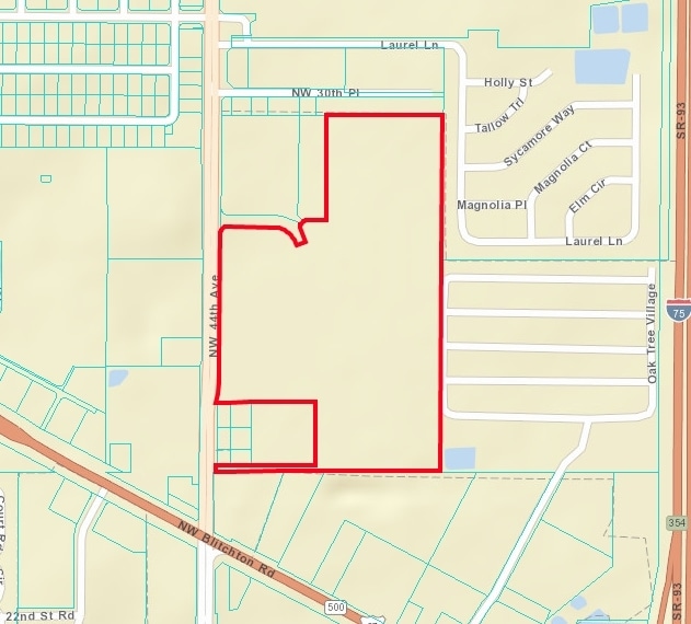
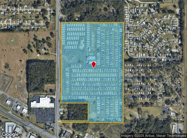
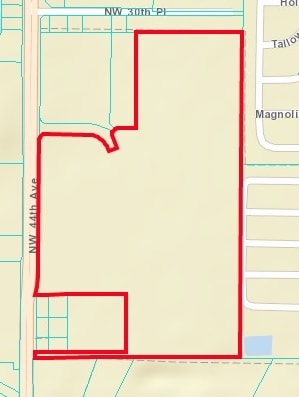
4213 Nw 27Th Pl
21532-001-00
Champions Run Ocala Luxury Rv Resort
Campgroundrvpark
SEC 03 TWP 15 RGE 21 COM AT SE COR OF NW 1/4 OF SE 1/4 OF SEC 3 TH N 00-26-58 E 1478.54 FT TO THE POB TH N 89-44-44 W 198.02 FT TH S 00-12-48 W 16.54 FT TH N 89-44-44 W 450.53 FT TO POC OF A 330 FT RADIUS CURVE CONCAVE SLY HAVING A CHORD BEARING & DI
X
Marion
12083C0504E
Florida
2024
55.14 AC
2024
Outlying Marion County
002503
Ocala
16,787 SF
Ocala, FL
DEMOGRAPHICS near 4213 Nw 27Th Pl
1 Mile
3 Mile
5 Mile
2024 Total Population
2,450
20,142
63,435
2029 Population
2,778
22,837
71,817
Pop Growth 2024-2029
+ 13.39%
+ 13.38%
+ 13.21%
Average Age
60
44
41
2024 Total Households
1,368
8,227
25,440
HH Growth 2024-2029
+ 13.30%
+ 13.55%
+ 13.27%
Median Household Inc
$67,387
$43,060
$48,325
Avg Household Size
1.80
2.20
2.30
2024 Avg HH Vehicles
2.00
2.00
2.00
Median Home Value
$232,309
$180,650
$192,604
Median Year Built
2000
1993
1987
Nearby Places
Map Layers
Map Styles
 Street
 Aerial
- Restaurants
- Banks
- Shops
- Fitness
- Groceries
Nearby Properties
Address
Land Use
TOTAL SIZE
Lot Size
Zoning
Address
Land Use
TOTAL SIZE
Lot Size
Zoning
2,015,469 SF
169.30 AC
M1
Address
Land Use
TOTAL SIZE
Lot Size
Zoning
704,765 SF
71.04 AC
GU
Address
Land Use
TOTAL SIZE
Lot Size
Zoning
493,261 SF
126.01 AC
R3
Address
Land Use
TOTAL SIZE
Lot Size
Zoning
1,085,670 SF
89.70 AC
M1
Address
Land Use
TOTAL SIZE
Lot Size
Zoning
612,196 SF
50.06 AC
M1
Address
Land Use
TOTAL SIZE
Lot Size
Zoning
617,520 SF
46.08 AC
M2
Address
Land Use
TOTAL SIZE
Lot Size
Zoning
441,040 SF
150.01 AC
M1
Address
Land Use
TOTAL SIZE
Lot Size
Zoning
458,983 SF
35.14 AC
M1
Address
Land Use
TOTAL SIZE
Lot Size
Zoning
444,381 SF
60 AC
M1
Address
Land Use
TOTAL SIZE
Lot Size
Zoning
403,023 SF
47.47 AC
M1
Address
Land Use
TOTAL SIZE
Lot Size
Zoning
350,895 SF
27.85 AC
M1
Address
Land Use
TOTAL SIZE
Lot Size
Zoning
421,243 SF
51.48 AC
M2
Address
Land Use
TOTAL SIZE
Lot Size
Zoning
604,920 SF
42.92 AC
M1
Address
Land Use
TOTAL SIZE
Lot Size
Zoning
392,617 SF
23.83 AC
M1
Address
Land Use
TOTAL SIZE
Lot Size
Zoning
482,618 SF
34.54 AC
M2
Address
Land Use
TOTAL SIZE
Lot Size
Zoning
360,450 SF
20 AC
M1
Address
Land Use
TOTAL SIZE
Lot Size
Zoning
140,920 SF
28.09 AC
M2
Address
Land Use
TOTAL SIZE
Lot Size
Zoning
146,091 SF
43.91 AC
M1
Address
Land Use
TOTAL SIZE
Lot Size
Zoning
9,854 SF
55.14 AC
B2
Address
Land Use
TOTAL SIZE
Lot Size
Zoning
29,068 SF
22.30 AC
PD
Address
Land Use
TOTAL SIZE
Lot Size
Zoning
112,663 SF
32.72 AC
INST
Address
Land Use
TOTAL SIZE
Lot Size
Zoning
265,793 SF
30 AC
M1
Address
Land Use
TOTAL SIZE
Lot Size
Zoning
79,199 SF
13.54 AC
B2
Address
Land Use
TOTAL SIZE
Lot Size
Zoning
160,796 SF
25.59 AC
M2
Address
Land Use
TOTAL SIZE
Lot Size
Zoning
384,930 SF
17.76 AC
M1
Address
Land Use
TOTAL SIZE
Lot Size
Zoning
153,456 SF
16.98 AC
M2
Address
Land Use
TOTAL SIZE
Lot Size
Zoning
91,987 SF
12 AC
M1
Address
Land Use
TOTAL SIZE
Lot Size
Zoning
94,360 SF
17.51 AC
B5
Address
Land Use
TOTAL SIZE
Lot Size
Zoning
80,571 SF
13.72 AC
INST
Address
Land Use
TOTAL SIZE
Lot Size
Zoning
101,760 SF
9.88 AC
M1
The World's #1 Commercial Real Estate Marketplace
Connect with us
© 2025 CoStar Group
The information above has been obtained from sources believed reliable. While we do not doubt its accuracy we have not verified it and make no guarantee, warranty or representation about it. It is your responsibility to independently confirm its accuracy and completeness. Any projections, opinions, assumptions, or estimates used are for example only and do not represent the current or future performance of the property. The value of this transaction to you depends on tax and other factors which should be evaluated by your tax, financial, and legal advisors. You and your advisors should conduct a careful, independent investigation of the property to determine to your satisfaction the suitability of the property for your needs.