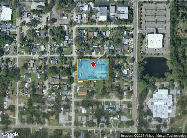
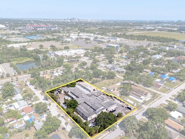
Property Record
4214 W Virginia Ave, Tampa, FL 33614
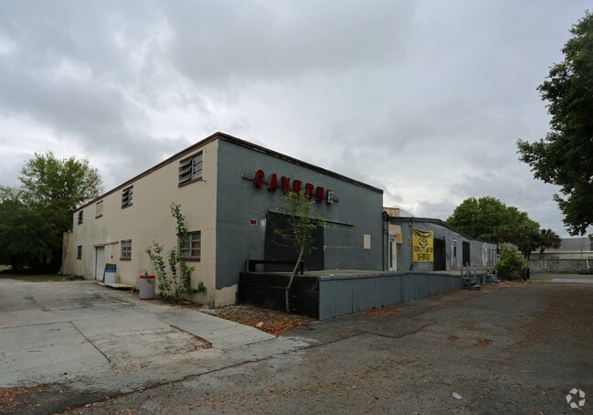

This Property Is For Sale
NEARBY LISTINGS FOR SALE OR LEASE
Property Detail
4214 W Virginia Ave
Tampa-St. Petersburg-Clearwater, FL
Drew Park Re Plat Of
A-09-29-18-3IP-000087-00007.0
DREW PARK RE PLAT OF LOTS 7 TO 14 INCL BLOCK 87
Warehouse
Hillsborough
X
Florida
12057C0332J
7
2024
1.92 AC
2024
Westshore/Airport
002600
Tampa/St Petersburg
45,659 SF
DEMOGRAPHICS near 4214 W Virginia Ave
1 Mile
3 Mile
5 Mile
2024 Total Population
1,469
94,842
294,809
2029 Population
1,539
103,750
322,137
Pop Growth 2024-2029
+ 4.77%
+ 9.39%
+ 9.27%
Average Age
39
40
39
2024 Total Households
583
39,218
124,380
HH Growth 2024-2029
+ 4.29%
+ 9.64%
+ 9.69%
Median Household Inc
$31,231
$56,049
$62,789
Avg Household Size
2.20
2.30
2.30
2024 Avg HH Vehicles
1.00
2.00
2.00
Median Home Value
$266,666
$305,233
$338,690
Median Year Built
1971
1977
1979
Nearby Places
- Restaurants
- Banks
- Shops
- Fitness
- Groceries
PUBLIC TRANSPORTATION
AIRPORT
Tampa International
DRIVE
WALK
Distance
Tampa International
11 min
4.8 mi
St Pete-Clearwater International
DRIVE
WALK
Distance
St Pete-Clearwater International
31 min
16.4 mi
Nearby Properties
Address
Land Use
TOTAL SIZE
Lot Size
Zoning
Address
Land Use
TOTAL SIZE
Lot Size
Zoning
2,308,592 SF
1,915.65 AC
M-AP-1
Address
Land Use
TOTAL SIZE
Lot Size
Zoning
927,709 SF
74.68 AC
PD-A
Address
Land Use
TOTAL SIZE
Lot Size
Zoning
1,278,217 SF
0.02 AC
CI
Address
Land Use
TOTAL SIZE
Lot Size
Zoning
1,083,666 SF
26.73 AC
OP-1
Address
Land Use
TOTAL SIZE
Lot Size
Zoning
142,972 SF
21.79 AC
M-AP-1
Address
Land Use
TOTAL SIZE
Lot Size
Zoning
532,661 SF
76.96 AC
CI
Address
Land Use
TOTAL SIZE
Lot Size
Zoning
429,656 SF
6.97 AC
PD
Address
Land Use
TOTAL SIZE
Lot Size
Zoning
401,486 SF
13.22 AC
PD-A
Address
Land Use
TOTAL SIZE
Lot Size
Zoning
387,234 SF
5.31 AC
OP-1
Address
Land Use
TOTAL SIZE
Lot Size
Zoning
352,071 SF
21.42 AC
M-AP-2
Address
Land Use
TOTAL SIZE
Lot Size
Zoning
598,902 SF
36.33 AC
PD
Address
Land Use
TOTAL SIZE
Lot Size
Zoning
367,609 SF
5.46 AC
PD
Address
Land Use
TOTAL SIZE
Lot Size
Zoning
393,971 SF
6.85 AC
PD
Address
Land Use
TOTAL SIZE
Lot Size
Zoning
306,362 SF
13.01 AC
PD
Address
Land Use
TOTAL SIZE
Lot Size
Zoning
309,242 SF
7.44 AC
PD-A
Address
Land Use
TOTAL SIZE
Lot Size
Zoning
305,936 SF
5.47 AC
PD-A
Address
Land Use
TOTAL SIZE
Lot Size
Zoning
2,226 SF
438.48 AC
SPI-AP-1
Address
Land Use
TOTAL SIZE
Lot Size
Zoning
485,897 SF
2.90 AC
PD
Address
Land Use
TOTAL SIZE
Lot Size
Zoning
344,612 SF
6.09 AC
PD
Address
Land Use
TOTAL SIZE
Lot Size
Zoning
373,594 SF
19.75 AC
PD
Address
Land Use
TOTAL SIZE
Lot Size
Zoning
521,097 SF
30.92 AC
RMC-20
Address
Land Use
TOTAL SIZE
Lot Size
Zoning
365,470 SF
13.29 AC
M-AP-1
Address
Land Use
TOTAL SIZE
Lot Size
Zoning
256,605 SF
2.49 AC
PD
Address
Land Use
TOTAL SIZE
Lot Size
Zoning
297,410 SF
3.43 AC
PD
Address
Land Use
TOTAL SIZE
Lot Size
Zoning
547,785 SF
65.86 AC
RMC-20
Address
Land Use
TOTAL SIZE
Lot Size
Zoning
263,583 SF
2.21 AC
PD
Address
Land Use
TOTAL SIZE
Lot Size
Zoning
259,936 SF
4.81 AC
PD-A
Address
Land Use
TOTAL SIZE
Lot Size
Zoning
265,351 SF
14.68 AC
PD
Address
Land Use
TOTAL SIZE
Lot Size
Zoning
238,971 SF
2.24 AC
PD
Address
Land Use
TOTAL SIZE
Lot Size
Zoning
247,794 SF
11.19 AC
PD
The World's #1 Commercial Real Estate Marketplace
Connect with us
© 2025 CoStar Group
The information above has been obtained from sources believed reliable. While we do not doubt its accuracy we have not verified it and make no guarantee, warranty or representation about it. It is your responsibility to independently confirm its accuracy and completeness. Any projections, opinions, assumptions, or estimates used are for example only and do not represent the current or future performance of the property. The value of this transaction to you depends on tax and other factors which should be evaluated by your tax, financial, and legal advisors. You and your advisors should conduct a careful, independent investigation of the property to determine to your satisfaction the suitability of the property for your needs.