Property Record
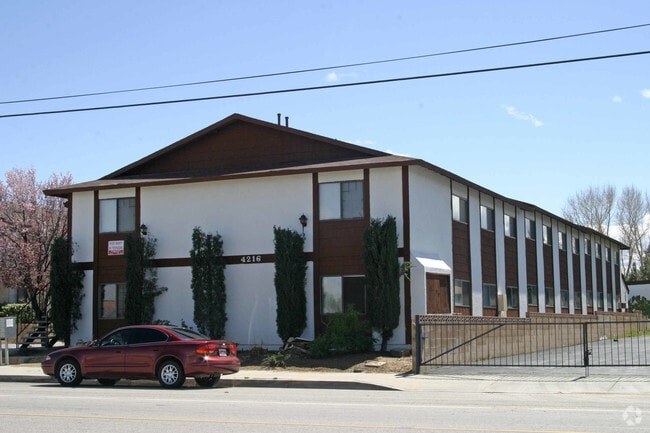
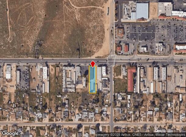
4216 W Avenue L, Lancaster, CA 93536
NEARBY LISTINGS FOR SALE OR LEASE
-
-
View all Lancaster listings for sale on LoopNet.com
Property Detail
4216 W Avenue L
Los Angeles-Long Beach-Glendale, CA
11921
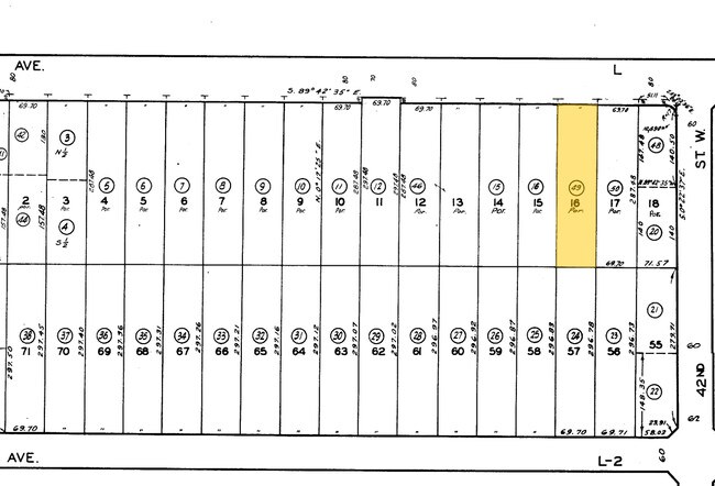
3103-023-049
TR=11921*(EX OF ST) LOT 16
Multifamilydwelling
Los Angeles
X
California
06037C0415F
16
2024
0.46 AC
2025
Outlying LA County
901102
Los Angeles
10,560 SF
DEMOGRAPHICS near 4216 W Avenue L
1 Mile
3 Mile
5 Mile
2024 Total Population
8,653
80,617
141,547
2029 Population
8,340
78,316
137,557
Pop Growth 2024-2029
(3.62%)
(2.85%)
(2.82%)
Average Age
37
39
38
2024 Total Households
2,818
26,706
46,700
HH Growth 2024-2029
(3.94%)
(3.10%)
(3.04%)
Median Household Inc
$75,434
$89,324
$78,659
Avg Household Size
3.00
2.90
2.90
2024 Avg HH Vehicles
2.00
2.00
2.00
Median Home Value
$366,666
$437,676
$412,046
Median Year Built
1980
1989
1987
Nearby Places
Map Layers
Map Styles
 Street
 Aerial
- Restaurants
- Banks
- Shops
- Fitness
- Groceries
PUBLIC TRANSPORTATION
COMMUTER RAIL
Lancaster (Antelope Valley Line - Southern California Regional Rail Authority (Metrolink))
DRIVE
WALK
Distance
Lancaster (Antelope Valley Line - Southern California Regional Rail Authority (Metrolink))
11 min
6.6 mi
Palmdale (Antelope Valley Line - Southern California Regional Rail Authority (Metrolink))
DRIVE
WALK
Distance
Palmdale (Antelope Valley Line - Southern California Regional Rail Authority (Metrolink))
15 min
9.5 mi
Freight Ports
Port of Long Beach
DRIVE
WALK
Distance
Port of Long Beach
110 min
93.7 mi
Nearby Properties
Address
Land Use
TOTAL SIZE
Lot Size
Zoning
Address
Land Use
TOTAL SIZE
Lot Size
Zoning
234,378 SF
15.25 AC
Address
Land Use
TOTAL SIZE
Lot Size
Zoning
153,117 SF
14.12 AC
LRSP80-01*
Address
Land Use
TOTAL SIZE
Lot Size
Zoning
160,028 SF
10.81 AC
LRMDR*
Address
Land Use
TOTAL SIZE
Lot Size
Zoning
179,304 SF
12.43 AC
LRMDR*
Address
Land Use
TOTAL SIZE
Lot Size
Zoning
212,198 SF
18.27 AC
LRSP80-01*
Address
Land Use
TOTAL SIZE
Lot Size
Zoning
129,896 SF
9.10 AC
LRRPD70001
Address
Land Use
TOTAL SIZE
Lot Size
Zoning
60,113 SF
2.03 AC
LRCPD
Address
Land Use
TOTAL SIZE
Lot Size
Zoning
123,924 SF
19.01 AC
LRA22*
Address
Land Use
TOTAL SIZE
Lot Size
Zoning
132,584 SF
8.66 AC
LRMDR*
Address
Land Use
TOTAL SIZE
Lot Size
Zoning
170,697 SF
9.29 AC
LRRPD12U*
Address
Land Use
TOTAL SIZE
Lot Size
Zoning
107,924 SF
8.95 AC
LRRPD10000
Address
Land Use
TOTAL SIZE
Lot Size
Zoning
58,043 SF
5.94 AC
PDC3
Address
Land Use
TOTAL SIZE
Lot Size
Zoning
183,296 SF
11.75 AC
LRRPD25U*
Address
Land Use
TOTAL SIZE
Lot Size
Zoning
52,263 SF
1.98 AC
LRCPD*
Address
Land Use
TOTAL SIZE
Lot Size
Zoning
146,468 SF
7.41 AC
LRA22*
Address
Land Use
TOTAL SIZE
Lot Size
Zoning
135,640 SF
6.56 AC
LRRPD75002
Address
Land Use
TOTAL SIZE
Lot Size
Zoning
201,515 SF
4.87 AC
LRCPD*
Address
Land Use
TOTAL SIZE
Lot Size
Zoning
62,739 SF
18.53 AC
LRA22
Address
Land Use
TOTAL SIZE
Lot Size
Zoning
46,328 SF
4.78 AC
LCR1 10000
Address
Land Use
TOTAL SIZE
Lot Size
Zoning
40,014 SF
1.64 AC
LRCPD*
Address
Land Use
TOTAL SIZE
Lot Size
Zoning
71,734 SF
5.93 AC
LRCPD
Address
Land Use
TOTAL SIZE
Lot Size
Zoning
126,813 SF
2.73 AC
LRRA7000*
Address
Land Use
TOTAL SIZE
Lot Size
Zoning
52,924 SF
4.76 AC
LRSP
Address
Land Use
TOTAL SIZE
Lot Size
Zoning
94,491 SF
9.57 AC
LRMDRI
Address
Land Use
TOTAL SIZE
Lot Size
Zoning
165,426 SF
5.03 AC
LRHDR-1
Address
Land Use
TOTAL SIZE
Lot Size
Zoning
53,237 SF
1.69 AC
LRCPD
Address
Land Use
TOTAL SIZE
Lot Size
Zoning
39,054 SF
3.92 AC
LRSP
Address
Land Use
TOTAL SIZE
Lot Size
Zoning
210,737 SF
5.10 AC
LRCPD*
Address
Land Use
TOTAL SIZE
Lot Size
Zoning
47,294 SF
4.45 AC
LRR315U*
Address
Land Use
TOTAL SIZE
Lot Size
Zoning
41,550 SF
6.36 AC
LRRA10000*
The World's #1 Commercial Real Estate Marketplace
Connect with us
© 2025 CoStar Group
The information above has been obtained from sources believed reliable. While we do not doubt its accuracy we have not verified it and make no guarantee, warranty or representation about it. It is your responsibility to independently confirm its accuracy and completeness. Any projections, opinions, assumptions, or estimates used are for example only and do not represent the current or future performance of the property. The value of this transaction to you depends on tax and other factors which should be evaluated by your tax, financial, and legal advisors. You and your advisors should conduct a careful, independent investigation of the property to determine to your satisfaction the suitability of the property for your needs.