Property Record
4217 Bluestone Rd, Cleveland, OH 44121
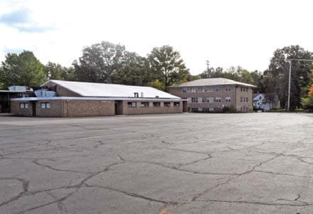
Property Detail
4217 Bluestone Rd
701-08-003
61
Daycare
CUYAHOGA
R-75
Ohio
B and X Area of moderate flood hazard, usually the area between the limits of the 100-year and 500-year floods.
61
2025
6.71 AC
2025
East
185101
Cleveland
58,104 SF
Cleveland-Elyria, OH
NEARBY LISTINGS FOR SALE OR LEASE
-
-
View all Cleveland listings for sale on LoopNet.com
DEMOGRAPHICS near 4217 Bluestone Rd
1 mile
3 mile
5 mile
2025 Total Population
14,569
116,004
296,030
2030 Population
14,450
116,040
297,133
Pop Growth 2025-2030
(0.82%)
+ 0.03%
+ 0.37%
Average Age
41
42
41
2025 Total Households
6,015
50,768
131,617
HH Growth 2025-2030
(0.98%)
+ 0.05%
+ 0.39%
Median Household Inc
$75,688
$57,994
$56,873
Avg Household Size
2.40
2.20
2.10
2025 Avg HH Vehicles
2.00
1.00
1.00
Median Home Value
$146,656
$165,664
$182,912
Median Year Built
1951
1952
1953
Nearby Places
Map Layers
Map Styles
 Street
 Aerial
Layers
 Traffic
 Biking
Places
Listings with unknown addresses are not visible on the map
- Restaurants
- Banks
- Shops
- Fitness
- Groceries
PUBLIC TRANSPORTATION
AIRPORT
Cleveland-Hopkins International
Drive
Walk
Distance
Cleveland-Hopkins International
43 min
22.7 mi
Freight Ports
Port of Toledo
Drive
Walk
Distance
Port of Toledo
156 min
122.8 mi
Nearby Properties
Address
Land Use
TOTAL SIZE
Lot Size
Zoning
Address
Land Use
TOTAL SIZE
Lot Size
Zoning
379,326 SF
43.45 AC
CRG
Address
Land Use
TOTAL SIZE
Lot Size
Zoning
44,577 SF
39.90 AC
SI
Address
Land Use
TOTAL SIZE
Lot Size
Zoning
257,048 SF
17.93 AC
S1
Address
Land Use
TOTAL SIZE
Lot Size
Zoning
112,657 SF
19.88 AC
U3
Address
Land Use
TOTAL SIZE
Lot Size
Zoning
149,685 SF
27.66 AC
R-1
Address
Land Use
TOTAL SIZE
Lot Size
Zoning
413,626 SF
21.95 AC
S2
Address
Land Use
TOTAL SIZE
Lot Size
Zoning
166,392 SF
36.46 AC
RMF-2
Address
Land Use
TOTAL SIZE
Lot Size
Zoning
91,540 SF
14.35 AC
CRG
Address
Land Use
TOTAL SIZE
Lot Size
Zoning
222,426 SF
3.60 AC
U1
Address
Land Use
TOTAL SIZE
Lot Size
Zoning
131,846 SF
5.94 AC
U-9
Address
Land Use
TOTAL SIZE
Lot Size
Zoning
628,514 SF
25.95 AC
B-2
Address
Land Use
TOTAL SIZE
Lot Size
Zoning
100,469 SF
25.96 AC
AA
Address
Land Use
TOTAL SIZE
Lot Size
Zoning
275,040 SF
9.07 AC
U3
Address
Land Use
TOTAL SIZE
Lot Size
Zoning
628,514 SF
0.67 AC
B-2
Address
Land Use
TOTAL SIZE
Lot Size
Zoning
64,535 SF
11.23 AC
U-5
Address
Land Use
TOTAL SIZE
Lot Size
Zoning
44,875 SF
4.87 AC
I-1
Address
Land Use
TOTAL SIZE
Lot Size
Zoning
47,055 SF
154.97 AC
I-1
Address
Land Use
TOTAL SIZE
Lot Size
Zoning
157,761 SF
14.27 AC
R-50
Address
Land Use
TOTAL SIZE
Lot Size
Zoning
186,262 SF
5.06 AC
U-4A
Address
Land Use
TOTAL SIZE
Lot Size
Zoning
61,352 SF
10.79 AC
M-I
Address
Land Use
TOTAL SIZE
Lot Size
Zoning
129,593 SF
72.95 AC
P
Address
Land Use
TOTAL SIZE
Lot Size
Zoning
249,374 SF
18.67 AC
1F-4
Address
Land Use
TOTAL SIZE
Lot Size
Zoning
162,679 SF
26.07 AC
1F-2
Address
Land Use
TOTAL SIZE
Lot Size
Zoning
97,120 SF
16.61 AC
C-C
Address
Land Use
TOTAL SIZE
Lot Size
Zoning
339,686 SF
5.65 AC
2F
Address
Land Use
TOTAL SIZE
Lot Size
Zoning
183,165 SF
18.93 AC
C-2
Address
Land Use
TOTAL SIZE
Lot Size
Zoning
38,200 SF
4.68 AC
U-5
Address
Land Use
TOTAL SIZE
Lot Size
Zoning
98,059 SF
10.78 AC
A
Address
Land Use
TOTAL SIZE
Lot Size
Zoning
80,547 SF
4.52 AC
CRG
Address
Land Use
TOTAL SIZE
Lot Size
Zoning
235,391 SF
4.90 AC
S1
The World's #1 Commercial Real Estate Marketplace
Connect with us
© 2026 CoStar Group
The information above has been obtained from sources believed reliable. While we do not doubt its accuracy we have not verified it and make no guarantee, warranty or representation about it. It is your responsibility to independently confirm its accuracy and completeness. Any projections, opinions, assumptions, or estimates used are for example only and do not represent the current or future performance of the property. The value of this transaction to you depends on tax and other factors which should be evaluated by your tax, financial, and legal advisors. You and your advisors should conduct a careful, independent investigation of the property to determine to your satisfaction the suitability of the property for your needs.