Property Record
4219 E Station Rd, Roanoke, IN 46783
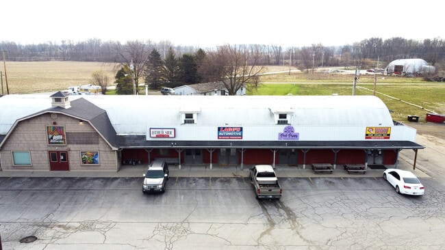


Property Detail
4219 E Station Rd
35-01-23-200-018.700-007
PT NW SEC 23 .70 AC
Storebuilding
Huntington
AE The base floodplain where base flood elevations are provided. AE Zones are now used on new format FIRMs instead of A1-A30 Zones.
Indiana
2024
0.70 AC
2025
Fort Wayne
961700
Other Market Areas
6,096 SF
Huntington, IN
NEARBY LISTINGS FOR SALE OR LEASE
-
-
View all Roanoke listings for sale on LoopNet.com
DEMOGRAPHICS near 4219 E Station Rd
1 mile
3 mile
5 mile
2025 Total Population
2,141
3,989
8,143
2030 Population
2,160
4,026
8,226
Pop Growth 2025-2030
+ 0.89%
+ 0.93%
+ 1.02%
Average Age
42
43
42
2025 Total Households
885
1,627
3,149
HH Growth 2025-2030
+ 0.90%
+ 0.98%
+ 1.05%
Median Household Inc
$77,971
$79,966
$91,812
Avg Household Size
2.40
2.40
2.60
2025 Avg HH Vehicles
2.00
2.00
2.00
Median Home Value
$245,652
$257,060
$306,863
Median Year Built
1990
1990
1989
Nearby Places
Map Layers
Map Styles
 Street
 Aerial
Layers
 Traffic
 Biking
Places
Listings with unknown addresses are not visible on the map
- Restaurants
- Banks
- Shops
- Fitness
- Groceries
PUBLIC TRANSPORTATION
AIRPORT
Fort Wayne International
Drive
Walk
Distance
Fort Wayne International
18 min
10.7 mi
Freight Ports
Port of Toledo
Drive
Walk
Distance
Port of Toledo
152 min
121.7 mi
SALE & LEASE HISTORY
LISTING DATE
SALE/LEASE

Jun 28, 2022
For Sale
Feb 17, 2017
For Lease
Feb 01, 2018
For Sale
Dec 18, 2020
For Sale
Nearby Properties
Address
Land Use
TOTAL SIZE
Lot Size
Zoning
Address
Land Use
TOTAL SIZE
Lot Size
Zoning
99,688 SF
87.88 AC
Address
Land Use
TOTAL SIZE
Lot Size
Zoning
94,605 SF
111.48 AC
Address
Land Use
TOTAL SIZE
Lot Size
Zoning
114,304 SF
283.30 AC
Address
Land Use
TOTAL SIZE
Lot Size
Zoning
5,960 SF
11.29 AC
Address
Land Use
TOTAL SIZE
Lot Size
Zoning
76,960 SF
152.71 AC
Address
Land Use
TOTAL SIZE
Lot Size
Zoning
11,913 SF
33.47 AC
Address
Land Use
TOTAL SIZE
Lot Size
Zoning
7,674 SF
1.02 AC
Address
Land Use
TOTAL SIZE
Lot Size
Zoning
33,420 SF
577.70 AC
Address
Land Use
TOTAL SIZE
Lot Size
Zoning
7,074 SF
1.39 AC
Address
Land Use
TOTAL SIZE
Lot Size
Zoning
7,998 SF
202.20 AC
Address
Land Use
TOTAL SIZE
Lot Size
Zoning
285.96 AC
Address
Land Use
TOTAL SIZE
Lot Size
Zoning
9,170 SF
1.57 AC
Address
Land Use
TOTAL SIZE
Lot Size
Zoning
1,740 SF
69.93 AC
Address
Land Use
TOTAL SIZE
Lot Size
Zoning
2,392 SF
26.72 AC
Address
Land Use
TOTAL SIZE
Lot Size
Zoning
42,872 SF
4.95 AC
Address
Land Use
TOTAL SIZE
Lot Size
Zoning
7,041 SF
252.60 AC
Address
Land Use
TOTAL SIZE
Lot Size
Zoning
6,790 SF
139.79 AC
Address
Land Use
TOTAL SIZE
Lot Size
Zoning
3,351 SF
0.87 AC
Address
Land Use
TOTAL SIZE
Lot Size
Zoning
7,477 SF
64.80 AC
Address
Land Use
TOTAL SIZE
Lot Size
Zoning
7,236 SF
0.83 AC
Address
Land Use
TOTAL SIZE
Lot Size
Zoning
1,440 SF
10.08 AC
Address
Land Use
TOTAL SIZE
Lot Size
Zoning
38,078 SF
0.55 AC
Address
Land Use
TOTAL SIZE
Lot Size
Zoning
6,684 SF
1.13 AC
Address
Land Use
TOTAL SIZE
Lot Size
Zoning
2,200 SF
2.42 AC
Address
Land Use
TOTAL SIZE
Lot Size
Zoning
7,176 SF
0.85 AC
Address
Land Use
TOTAL SIZE
Lot Size
Zoning
16,350 SF
9.09 AC
Address
Land Use
TOTAL SIZE
Lot Size
Zoning
7,920 SF
0.18 AC
Address
Land Use
TOTAL SIZE
Lot Size
Zoning
4,733 SF
33.84 AC
Address
Land Use
TOTAL SIZE
Lot Size
Zoning
5,069 SF
145.80 AC
Address
Land Use
TOTAL SIZE
Lot Size
Zoning
166.16 AC
The World's #1 Commercial Real Estate Marketplace
Connect with us
© 2026 CoStar Group
The information above has been obtained from sources believed reliable. While we do not doubt its accuracy we have not verified it and make no guarantee, warranty or representation about it. It is your responsibility to independently confirm its accuracy and completeness. Any projections, opinions, assumptions, or estimates used are for example only and do not represent the current or future performance of the property. The value of this transaction to you depends on tax and other factors which should be evaluated by your tax, financial, and legal advisors. You and your advisors should conduct a careful, independent investigation of the property to determine to your satisfaction the suitability of the property for your needs.