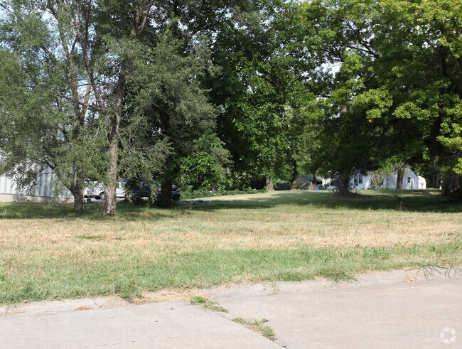
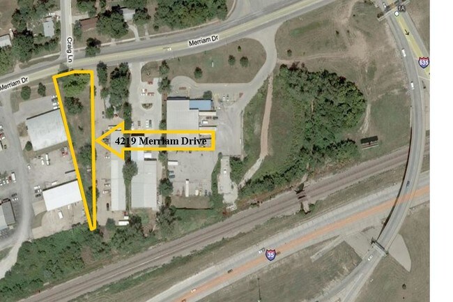
Property Record
4219 Merriam Dr, Shawnee, KS 66203

NEARBY LISTINGS FOR SALE OR LEASE
Property Detail
4219 Merriam Dr
Kansas City, MO-KS
Southwest Gardens Beg Nw Cor
NP80800000-0046B
SOUTHWEST GARDENS BEG NW COR LOT 46 E TO NE COR SLY TO SE COR NWLY TO PT OF BEG OPC-5311 0001
Warehouse
Johnson
X
Kansas
20209C0170D
46
2024
0.43 AC
2024
Northwest Johnson County
052201
Kansas City
DEMOGRAPHICS near 4219 Merriam Dr
1 Mile
3 Mile
5 Mile
2024 Total Population
8,811
73,637
209,866
2029 Population
8,938
74,640
213,766
Pop Growth 2024-2029
+ 1.44%
+ 1.36%
+ 1.86%
Average Age
37
39
39
2024 Total Households
4,096
31,775
91,882
HH Growth 2024-2029
+ 2.12%
+ 1.79%
+ 2.13%
Median Household Inc
$55,924
$68,018
$71,531
Avg Household Size
2.10
2.30
2.20
2024 Avg HH Vehicles
2.00
2.00
2.00
Median Home Value
$177,864
$219,079
$260,933
Median Year Built
1971
1961
1961
Nearby Places
Map Layers
Map Styles
 Street
 Aerial
- Restaurants
- Banks
- Shops
- Fitness
- Groceries
PUBLIC TRANSPORTATION
COMMUTER RAIL
DRIVE
WALK
Distance
14 min
8.1 mi
AIRPORT
Kansas City International
DRIVE
WALK
Distance
Kansas City International
31 min
24.3 mi
Nearby Properties
Address
Land Use
TOTAL SIZE
Lot Size
Zoning
Address
Land Use
TOTAL SIZE
Lot Size
Zoning
312,446 SF
39.35 AC
R-1
Address
Land Use
TOTAL SIZE
Lot Size
Zoning
249,363 SF
58.59 AC
Address
Land Use
TOTAL SIZE
Lot Size
Zoning
133,505 SF
16.41 AC
R-1
Address
Land Use
TOTAL SIZE
Lot Size
Zoning
212,475 SF
30.20 AC
PUB
Address
Land Use
TOTAL SIZE
Lot Size
Zoning
96,501 SF
6.49 AC
Address
Land Use
TOTAL SIZE
Lot Size
Zoning
89,477 SF
16.45 AC
R-1
Address
Land Use
TOTAL SIZE
Lot Size
Zoning
42,597 SF
4.39 AC
MS2
Address
Land Use
TOTAL SIZE
Lot Size
Zoning
63,471 SF
7.36 AC
PARK
Address
Land Use
TOTAL SIZE
Lot Size
Zoning
90,774 SF
1.73 AC
MS2
Address
Land Use
TOTAL SIZE
Lot Size
Zoning
100,090 SF
48.47 AC
KR1
Address
Land Use
TOTAL SIZE
Lot Size
Zoning
96,856 SF
15.76 AC
R-1
Address
Land Use
TOTAL SIZE
Lot Size
Zoning
93,418 SF
12.07 AC
R-1
Address
Land Use
TOTAL SIZE
Lot Size
Zoning
21,635 SF
10.75 AC
KRP5
Address
Land Use
TOTAL SIZE
Lot Size
Zoning
24,920 SF
7.84 AC
KRP5
Address
Land Use
TOTAL SIZE
Lot Size
Zoning
100,784 SF
4.68 AC
C-2B
Address
Land Use
TOTAL SIZE
Lot Size
Zoning
74,212 SF
8.01 AC
R-1
Address
Land Use
TOTAL SIZE
Lot Size
Zoning
13,210 SF
7.80 AC
KRP5
Address
Land Use
TOTAL SIZE
Lot Size
Zoning
74,802 SF
10.55 AC
CP-O
Address
Land Use
TOTAL SIZE
Lot Size
Zoning
77,648 SF
6.90 AC
R-1
Address
Land Use
TOTAL SIZE
Lot Size
Zoning
311,454 SF
40.91 AC
PUD-G
Address
Land Use
TOTAL SIZE
Lot Size
Zoning
667,586 SF
18.06 AC
PUD-G
Address
Land Use
TOTAL SIZE
Lot Size
Zoning
34,745 SF
8.96 AC
PARK
Address
Land Use
TOTAL SIZE
Lot Size
Zoning
82,035 SF
8.49 AC
R-1
Address
Land Use
TOTAL SIZE
Lot Size
Zoning
111,880 SF
36.74 AC
KR1
Address
Land Use
TOTAL SIZE
Lot Size
Zoning
78,488 SF
5.95 AC
PUB
Address
Land Use
TOTAL SIZE
Lot Size
Zoning
62,452 SF
14.89 AC
KR1
Address
Land Use
TOTAL SIZE
Lot Size
Zoning
80,474 SF
11.30 AC
R-1
Address
Land Use
TOTAL SIZE
Lot Size
Zoning
14,744 SF
0.97 AC
Address
Land Use
TOTAL SIZE
Lot Size
Zoning
26,364 SF
6.04 AC
CP-O
Address
Land Use
TOTAL SIZE
Lot Size
Zoning
96,759 SF
2.46 AC
C-2B
The World's #1 Commercial Real Estate Marketplace
Connect with us
© 2025 CoStar Group
The information above has been obtained from sources believed reliable. While we do not doubt its accuracy we have not verified it and make no guarantee, warranty or representation about it. It is your responsibility to independently confirm its accuracy and completeness. Any projections, opinions, assumptions, or estimates used are for example only and do not represent the current or future performance of the property. The value of this transaction to you depends on tax and other factors which should be evaluated by your tax, financial, and legal advisors. You and your advisors should conduct a careful, independent investigation of the property to determine to your satisfaction the suitability of the property for your needs.