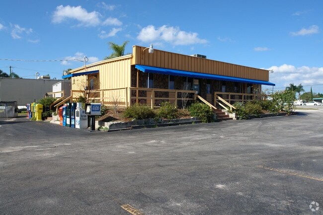
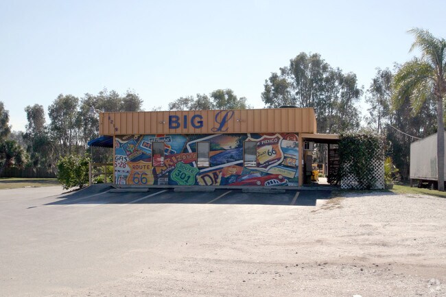
Property Record
4219 Us Highway 301 N, Ellenton, FL 34222
NEARBY LISTINGS FOR SALE OR LEASE
Property Detail
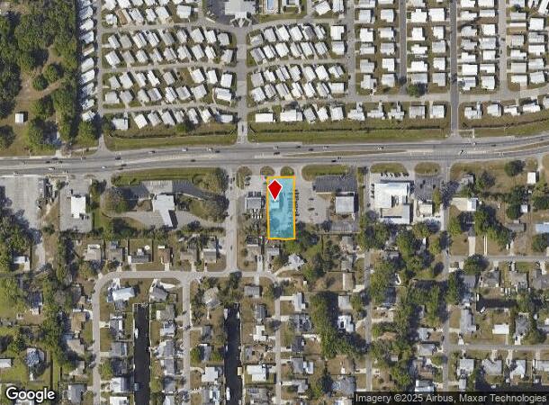
4219 Us Highway 301 N
North Port-Sarasota-Bradenton, FL
Tropical Harbor Section 1
9706-0000-3
THE E 65FT OF LOT 4 TROPICAL HARBOR, TOGETHER WITH: BEG AT NE COR OF SD LOT 4; TH S 0 DEG 40 MIN 20 SEC E, 234.03 FT TO THE SE COR OF SD LOT 4; TH N 89 DEG 19 MIN 40 SEC E, 35 FT;
Restaurantbuilding
Manatee
AE
Florida
12081C0169F
4
2023
0.54 AC
2025
Manatee
001904
Tampa/St Petersburg
2,440 SF
DEMOGRAPHICS near 4219 Us Highway 301 N
1 Mile
3 Mile
5 Mile
2024 Total Population
3,540
58,738
149,270
2029 Population
4,196
68,928
174,833
Pop Growth 2024-2029
+ 18.53%
+ 17.35%
+ 17.13%
Average Age
47
44
44
2024 Total Households
1,509
23,618
59,613
HH Growth 2024-2029
+ 17.56%
+ 16.56%
+ 16.43%
Median Household Inc
$55,942
$57,402
$60,162
Avg Household Size
2.20
2.40
2.40
2024 Avg HH Vehicles
1.00
2.00
2.00
Median Home Value
$327,564
$240,906
$255,897
Median Year Built
1982
1994
1991
Nearby Places
Map Layers
Map Styles
 Street
 Aerial
- Restaurants
- Banks
- Shops
- Fitness
- Groceries
PUBLIC TRANSPORTATION
AIRPORT
Sarasota/Bradenton International
DRIVE
WALK
Distance
Sarasota/Bradenton International
26 min
12.9 mi
St Pete-Clearwater International
DRIVE
WALK
Distance
St Pete-Clearwater International
48 min
35.8 mi
Tampa International
DRIVE
WALK
Distance
Tampa International
60 min
45.0 mi
Freight Ports
Port Manatee
DRIVE
WALK
Distance
Port Manatee
19 min
10.8 mi
Nearby Properties
Address
Land Use
TOTAL SIZE
Lot Size
Zoning
Address
Land Use
TOTAL SIZE
Lot Size
Zoning
622,266 SF
68.76 AC
PD-MU
Address
Land Use
TOTAL SIZE
Lot Size
Zoning
881,490 SF
83.09 AC
BR_R-3
Address
Land Use
TOTAL SIZE
Lot Size
Zoning
513,465 SF
78.39 AC
PD-MU
Address
Land Use
TOTAL SIZE
Lot Size
Zoning
707,409 SF
27.98 AC
PD-MU
Address
Land Use
TOTAL SIZE
Lot Size
Zoning
349,711 SF
49.51 AC
BR_SD1
Address
Land Use
TOTAL SIZE
Lot Size
Zoning
359,241 SF
27.68 AC
PD-MU
Address
Land Use
TOTAL SIZE
Lot Size
Zoning
277,678 SF
7.80 AC
BR_T4-O, B
Address
Land Use
TOTAL SIZE
Lot Size
Zoning
319,679 SF
31.78 AC
BR_R-1
Address
Land Use
TOTAL SIZE
Lot Size
Zoning
427,250 SF
38.18 AC
A-1 SUBURB
Address
Land Use
TOTAL SIZE
Lot Size
Zoning
98,722 SF
10.24 AC
PL_P
Address
Land Use
TOTAL SIZE
Lot Size
Zoning
169,485 SF
7.87 AC
PD-MU
Address
Land Use
TOTAL SIZE
Lot Size
Zoning
318,507 SF
10.47 AC
BR_T4R,BR_
Address
Land Use
TOTAL SIZE
Lot Size
Zoning
311,669 SF
34.55 AC
BR_R-2
Address
Land Use
TOTAL SIZE
Lot Size
Zoning
225,768 SF
18.47 AC
BR_R-1
Address
Land Use
TOTAL SIZE
Lot Size
Zoning
456,375 SF
112.07 AC
PD-MU
Address
Land Use
TOTAL SIZE
Lot Size
Zoning
885,776 SF
46.22 AC
LM LIGHT M
Address
Land Use
TOTAL SIZE
Lot Size
Zoning
270,900 SF
44.35 AC
PD-MU
Address
Land Use
TOTAL SIZE
Lot Size
Zoning
348,901 SF
27 AC
BR_R-2
Address
Land Use
TOTAL SIZE
Lot Size
Zoning
456,317 SF
46.75 AC
PD-R
Address
Land Use
TOTAL SIZE
Lot Size
Zoning
276,469 SF
10.90 AC
PD-MU
Address
Land Use
TOTAL SIZE
Lot Size
Zoning
191,100 SF
30.35 AC
PD-C
Address
Land Use
TOTAL SIZE
Lot Size
Zoning
107,298 SF
12.91 AC
PD-MU
Address
Land Use
TOTAL SIZE
Lot Size
Zoning
229,863 SF
31.01 AC
PL_CG,PL_C
Address
Land Use
TOTAL SIZE
Lot Size
Zoning
220,706 SF
24.13 AC
PD-C, A-1
Address
Land Use
TOTAL SIZE
Lot Size
Zoning
257,697 SF
5.32 AC
PL_PD-H
Address
Land Use
TOTAL SIZE
Lot Size
Zoning
256,584 SF
12.57 AC
PD-MU
Address
Land Use
TOTAL SIZE
Lot Size
Zoning
234,818 SF
18.20 AC
BR_R-2
Address
Land Use
TOTAL SIZE
Lot Size
Zoning
171,461 SF
7.56 AC
PL_CHI
Address
Land Use
TOTAL SIZE
Lot Size
Zoning
201,982 SF
16.65 AC
BR_SCC
Address
Land Use
TOTAL SIZE
Lot Size
Zoning
185,272 SF
18.11 AC
PD-R
The World's #1 Commercial Real Estate Marketplace
Connect with us
© 2025 CoStar Group
The information above has been obtained from sources believed reliable. While we do not doubt its accuracy we have not verified it and make no guarantee, warranty or representation about it. It is your responsibility to independently confirm its accuracy and completeness. Any projections, opinions, assumptions, or estimates used are for example only and do not represent the current or future performance of the property. The value of this transaction to you depends on tax and other factors which should be evaluated by your tax, financial, and legal advisors. You and your advisors should conduct a careful, independent investigation of the property to determine to your satisfaction the suitability of the property for your needs.