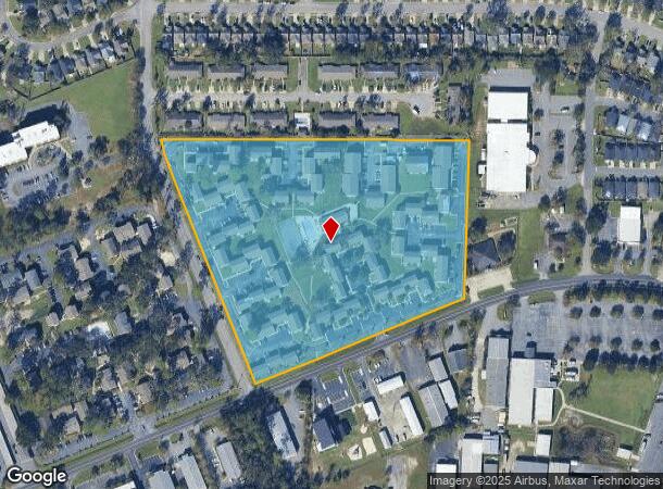
Property Record
422 Connell Rd, Valdosta, GA 31602
NEARBY LISTINGS FOR SALE OR LEASE
Property Detail
422 Connell Rd
0112A-113
Apartments Grp2
Multifamilydwelling
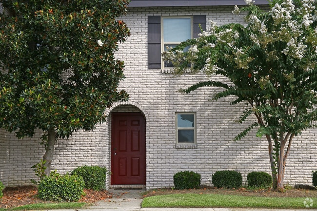
SPANISH MISSION APTS
X
Lowndes
13185C0210E
Georgia
2024
12 AC
2024
Valdosta/Lake Park
010601
Other Market Areas
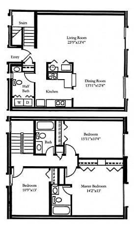
2,574 SF
Valdosta, GA
DEMOGRAPHICS near 422 Connell Rd
1 Mile
3 Mile
5 Mile
2024 Total Population
8,400
48,999
76,025
2029 Population
8,703
50,752
78,932
Pop Growth 2024-2029
+ 3.61%
+ 3.58%
+ 3.82%
Average Age
35
35
35
2024 Total Households
3,544
19,492
29,433
HH Growth 2024-2029
+ 3.75%
+ 3.75%
+ 4.00%
Median Household Inc
$31,172
$34,786
$38,788
Avg Household Size
2.20
2.30
2.40
2024 Avg HH Vehicles
1.00
2.00
2.00
Median Home Value
$123,136
$162,590
$168,853
Median Year Built
1988
1986
1990
Nearby Places
Map Layers
Map Styles
 Street
 Aerial
- Restaurants
- Banks
- Shops
- Fitness
- Groceries
PUBLIC TRANSPORTATION
AIRPORT
Valdosta Regional
DRIVE
WALK
Distance
Valdosta Regional
15 min
6.8 mi
Freight Ports
Jacksonville Port
DRIVE
WALK
Distance
Jacksonville Port
152 min
129.7 mi
Nearby Properties
Address
Land Use
TOTAL SIZE
Lot Size
Zoning
Address
Land Use
TOTAL SIZE
Lot Size
Zoning
39,024 SF
18.04 AC
P-D
Address
Land Use
TOTAL SIZE
Lot Size
Zoning
1,728 SF
24.30 AC
R-P, C-C
Address
Land Use
TOTAL SIZE
Lot Size
Zoning
4,878 SF
14.83 AC
R-P
Address
Land Use
TOTAL SIZE
Lot Size
Zoning
210,020 SF
4.22 AC
C-C
Address
Land Use
TOTAL SIZE
Lot Size
Zoning
15.75 AC
R-P
Address
Land Use
TOTAL SIZE
Lot Size
Zoning
339 SF
23.53 AC
E-R
Address
Land Use
TOTAL SIZE
Lot Size
Zoning
19,825 SF
16.93 AC
R-M
Address
Land Use
TOTAL SIZE
Lot Size
Zoning
185,727 SF
20.33 AC
C-H
Address
Land Use
TOTAL SIZE
Lot Size
Zoning
32,886 SF
5.45 AC
C-C
Address
Land Use
TOTAL SIZE
Lot Size
Zoning
114,922 SF
11.38 AC
C-C
Address
Land Use
TOTAL SIZE
Lot Size
Zoning
142,140 SF
24.29 AC
DR-10
Address
Land Use
TOTAL SIZE
Lot Size
Zoning
101,792 SF
14.09 AC
C-H
Address
Land Use
TOTAL SIZE
Lot Size
Zoning
24,928 SF
10 AC
R-M
Address
Land Use
TOTAL SIZE
Lot Size
Zoning
65,664 SF
16.06 AC
R-M
Address
Land Use
TOTAL SIZE
Lot Size
Zoning
7,200 SF
9.92 AC
M-1
Address
Land Use
TOTAL SIZE
Lot Size
Zoning
40,800 SF
5.83 AC
R-P
Address
Land Use
TOTAL SIZE
Lot Size
Zoning
53,880 SF
8.01 AC
C-H,C-C
Address
Land Use
TOTAL SIZE
Lot Size
Zoning
50,016 SF
3.79 AC
C-C
Address
Land Use
TOTAL SIZE
Lot Size
Zoning
574 SF
7.28 AC
PPD
Address
Land Use
TOTAL SIZE
Lot Size
Zoning
93,032 SF
2.80 AC
C-H
Address
Land Use
TOTAL SIZE
Lot Size
Zoning
78,048 SF
9.18 AC
R-P
Address
Land Use
TOTAL SIZE
Lot Size
Zoning
13,056 SF
9.41 AC
R-M
Address
Land Use
TOTAL SIZE
Lot Size
Zoning
1,902 SF
10.58 AC
R-M
Address
Land Use
TOTAL SIZE
Lot Size
Zoning
48,000 SF
9.06 AC
C-C
Address
Land Use
TOTAL SIZE
Lot Size
Zoning
110,646 SF
9.76 AC
R-P
Address
Land Use
TOTAL SIZE
Lot Size
Zoning
69,200 SF
7.22 AC
C-H
Address
Land Use
TOTAL SIZE
Lot Size
Zoning
49,546 SF
10.45 AC
R-P
Address
Land Use
TOTAL SIZE
Lot Size
Zoning
57,408 SF
4.18 AC
C-C
Address
Land Use
TOTAL SIZE
Lot Size
Zoning
202,062 SF
7.12 AC
R-15
The World's #1 Commercial Real Estate Marketplace
Connect with us
© 2025 CoStar Group
The information above has been obtained from sources believed reliable. While we do not doubt its accuracy we have not verified it and make no guarantee, warranty or representation about it. It is your responsibility to independently confirm its accuracy and completeness. Any projections, opinions, assumptions, or estimates used are for example only and do not represent the current or future performance of the property. The value of this transaction to you depends on tax and other factors which should be evaluated by your tax, financial, and legal advisors. You and your advisors should conduct a careful, independent investigation of the property to determine to your satisfaction the suitability of the property for your needs.