Property Record
4220 Coonpath Rd, Carroll, OH 43112
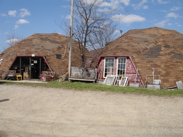

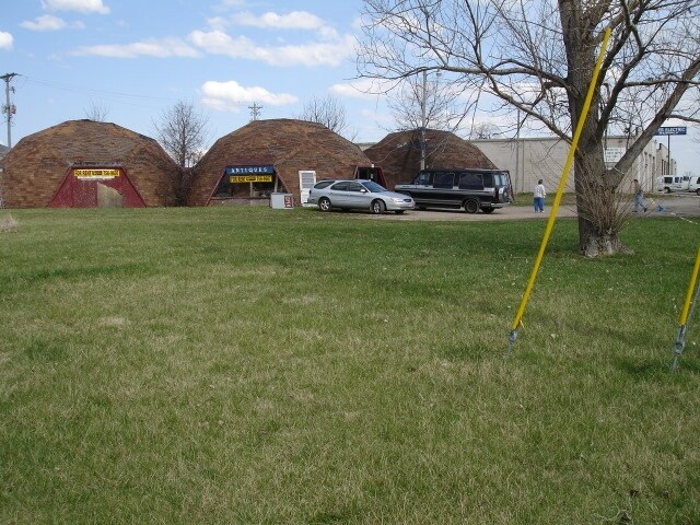
Property Detail
4220 Coonpath Rd
01-30046-700
R 19 T 15 S 17 SE
Warehouse
Fairfield
B and X Area of moderate flood hazard, usually the area between the limits of the 100-year and 500-year floods.
Ohio
2024
4.22 AC
2025
Fairfield County
030902
Columbus
23,000 SF
Columbus, OH
NEARBY LISTINGS FOR SALE OR LEASE
DEMOGRAPHICS near 4220 Coonpath Rd
1 mile
3 mile
5 mile
2025 Total Population
73
7,133
27,099
2030 Population
78
7,341
28,335
Pop Growth 2025-2030
+ 6.85%
+ 2.92%
+ 4.56%
Average Age
49
42
42
2025 Total Households
26
2,678
10,767
HH Growth 2025-2030
+ 3.85%
+ 3.17%
+ 4.89%
Median Household Inc
$83,928
$80,845
$76,924
Avg Household Size
2.50
2.60
2.50
2025 Avg HH Vehicles
2.00
2.00
2.00
Median Home Value
$340,000
$323,825
$287,207
Median Year Built
1977
1991
1979
Nearby Places
Map Layers
Map Styles
 Street
 Aerial
Layers
 Traffic
 Biking
Places
Listings with unknown addresses are not visible on the map
- Restaurants
- Banks
- Shops
- Fitness
- Groceries
PUBLIC TRANSPORTATION
AIRPORT
Rickenbacker International
Drive
Walk
Distance
Rickenbacker International
30 min
21.0 mi
John Glenn Columbus International
Drive
Walk
Distance
John Glenn Columbus International
33 min
24.1 mi
Nearby Properties
Address
Land Use
TOTAL SIZE
Lot Size
Zoning
Address
Land Use
TOTAL SIZE
Lot Size
Zoning
1,278,248 SF
65.57 AC
Address
Land Use
TOTAL SIZE
Lot Size
Zoning
244,644 SF
39.47 AC
Address
Land Use
TOTAL SIZE
Lot Size
Zoning
88,522 SF
37.42 AC
Address
Land Use
TOTAL SIZE
Lot Size
Zoning
130,341 SF
43.19 AC
Address
Land Use
TOTAL SIZE
Lot Size
Zoning
111,562 SF
38.37 AC
Address
Land Use
TOTAL SIZE
Lot Size
Zoning
330,207 SF
17.97 AC
Address
Land Use
TOTAL SIZE
Lot Size
Zoning
330,207 SF
17.97 AC
Address
Land Use
TOTAL SIZE
Lot Size
Zoning
192,310 SF
18.39 AC
Address
Land Use
TOTAL SIZE
Lot Size
Zoning
206,574 SF
30.14 AC
Address
Land Use
TOTAL SIZE
Lot Size
Zoning
33,925 SF
7.74 AC
Address
Land Use
TOTAL SIZE
Lot Size
Zoning
49,275 SF
6 AC
Address
Land Use
TOTAL SIZE
Lot Size
Zoning
35,517 SF
5.66 AC
Address
Land Use
TOTAL SIZE
Lot Size
Zoning
53,874 SF
38.33 AC
Address
Land Use
TOTAL SIZE
Lot Size
Zoning
26,700 SF
1.83 AC
Address
Land Use
TOTAL SIZE
Lot Size
Zoning
21,834 SF
11.77 AC
Address
Land Use
TOTAL SIZE
Lot Size
Zoning
128,360 SF
10.31 AC
Address
Land Use
TOTAL SIZE
Lot Size
Zoning
82,284 SF
10.49 AC
Address
Land Use
TOTAL SIZE
Lot Size
Zoning
21,114 SF
9.04 AC
Address
Land Use
TOTAL SIZE
Lot Size
Zoning
32,732 SF
3.71 AC
Address
Land Use
TOTAL SIZE
Lot Size
Zoning
38,158 SF
7.48 AC
Address
Land Use
TOTAL SIZE
Lot Size
Zoning
18,871 SF
13.71 AC
Address
Land Use
TOTAL SIZE
Lot Size
Zoning
34,819 SF
3.63 AC
Address
Land Use
TOTAL SIZE
Lot Size
Zoning
20,565 SF
9 AC
Address
Land Use
TOTAL SIZE
Lot Size
Zoning
161,008 SF
8.99 AC
Address
Land Use
TOTAL SIZE
Lot Size
Zoning
55,600 SF
8.47 AC
Address
Land Use
TOTAL SIZE
Lot Size
Zoning
72,300 SF
5.20 AC
Address
Land Use
TOTAL SIZE
Lot Size
Zoning
Address
Land Use
TOTAL SIZE
Lot Size
Zoning
19,836 SF
11 AC
Address
Land Use
TOTAL SIZE
Lot Size
Zoning
51,791 SF
29.98 AC
Address
Land Use
TOTAL SIZE
Lot Size
Zoning
119,974 SF
7.18 AC
The World's #1 Commercial Real Estate Marketplace
Connect with us
© 2026 CoStar Group
The information above has been obtained from sources believed reliable. While we do not doubt its accuracy we have not verified it and make no guarantee, warranty or representation about it. It is your responsibility to independently confirm its accuracy and completeness. Any projections, opinions, assumptions, or estimates used are for example only and do not represent the current or future performance of the property. The value of this transaction to you depends on tax and other factors which should be evaluated by your tax, financial, and legal advisors. You and your advisors should conduct a careful, independent investigation of the property to determine to your satisfaction the suitability of the property for your needs.