Property Record
4220 Tuscarora Rd, Point Of Rocks, MD 21777
NEARBY LISTINGS FOR SALE OR LEASE
-
-
View all Point Of Rocks listings for sale on LoopNet.com
Property Detail
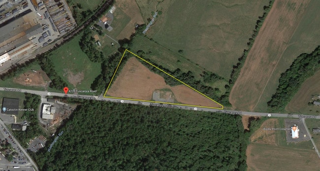
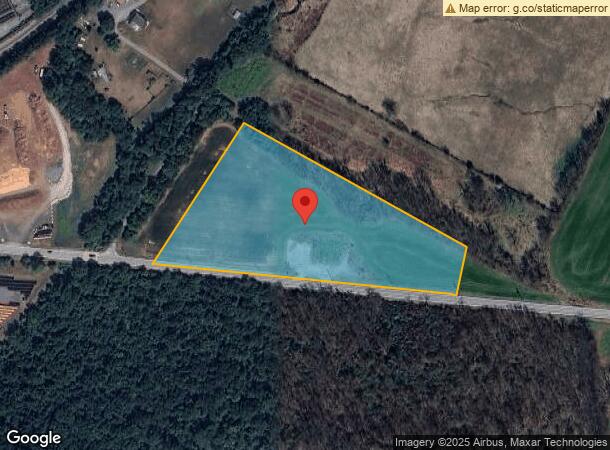
4220 Tuscarora Rd
01-012444
6.8 AC N/S ROUTE 28 E/B & O TRACKS
Commercialnec
Frederick
AE
Maryland
24021C0269E
6.80 AC
2024
Frederick
2025
Washington, DC
752303
Washington-Arlington-Alexandria, DC-VA-MD-WV
6,822 SF
DEMOGRAPHICS near 4220 Tuscarora Rd
1 Mile
3 Mile
5 Mile
2024 Total Population
1,997
4,766
11,786
2029 Population
2,248
5,300
13,076
Pop Growth 2024-2029
+ 12.57%
+ 11.20%
+ 10.95%
Average Age
39
40
41
2024 Total Households
675
1,579
3,958
HH Growth 2024-2029
+ 13.04%
+ 11.65%
+ 11.34%
Median Household Inc
$119,230
$140,589
$147,182
Avg Household Size
2.90
3.00
2.90
2024 Avg HH Vehicles
2.00
2.00
3.00
Median Home Value
$381,557
$467,927
$566,438
Median Year Built
1993
1994
1994
Nearby Places
Map Layers
Map Styles
 Street
 Aerial
- Restaurants
- Banks
- Shops
- Fitness
- Groceries
PUBLIC TRANSPORTATION
COMMUTER RAIL
Point Of Rocks (BRUNSWICK - WASHINGTON - Maryland Area Regional Commuter Trains (The MARC), Brunswick Line - Maryland Area Regional Commuter Trains (The MARC))
DRIVE
WALK
Distance
Point Of Rocks (BRUNSWICK - WASHINGTON - Maryland Area Regional Commuter Trains (The MARC), Brunswick Line - Maryland Area Regional Commuter Trains (The MARC))
2 min
15 min
0.8 mi
AIRPORT
Washington Dulles International
DRIVE
WALK
Distance
Washington Dulles International
51 min
30.8 mi
Freight Ports
Port of Baltimore
DRIVE
WALK
Distance
Port of Baltimore
78 min
62.5 mi
SALE & LEASE HISTORY
LISTING DATE
SALE/LEASE

Oct 29, 2018
For Lease
Oct 26, 2018
For Sale
Dec 20, 2019
For Sale
Nearby Properties
Address
Land Use
TOTAL SIZE
Lot Size
Zoning
Address
Land Use
TOTAL SIZE
Lot Size
Zoning
55,005 SF
15.83 AC
A
Address
Land Use
TOTAL SIZE
Lot Size
Zoning
272,878 SF
7.05 AC
GI
Address
Land Use
TOTAL SIZE
Lot Size
Zoning
36,518 SF
38.47 AC
A
Address
Land Use
TOTAL SIZE
Lot Size
Zoning
26,922 SF
103.43 AC
A
Address
Land Use
TOTAL SIZE
Lot Size
Zoning
103,538 SF
7.08 AC
GI
Address
Land Use
TOTAL SIZE
Lot Size
Zoning
6,589 SF
3.17 AC
PUD
Address
Land Use
TOTAL SIZE
Lot Size
Zoning
1.02 AC
PUD
Address
Land Use
TOTAL SIZE
Lot Size
Zoning
11,437 SF
6.51 AC
GI
Address
Land Use
TOTAL SIZE
Lot Size
Zoning
7,972 SF
3.40 AC
AR1
Address
Land Use
TOTAL SIZE
Lot Size
Zoning
4.40 AC
RC
Address
Land Use
TOTAL SIZE
Lot Size
Zoning
31,510 SF
6.34 AC
GI
Address
Land Use
TOTAL SIZE
Lot Size
Zoning
5,131 SF
0.92 AC
RC
Address
Land Use
TOTAL SIZE
Lot Size
Zoning
8,200 SF
1.52 AC
GC
Address
Land Use
TOTAL SIZE
Lot Size
Zoning
5,056 SF
199.58 AC
A
Address
Land Use
TOTAL SIZE
Lot Size
Zoning
4,053 SF
4 AC
R3
Address
Land Use
TOTAL SIZE
Lot Size
Zoning
2,576 SF
16.65 AC
AR1
Address
Land Use
TOTAL SIZE
Lot Size
Zoning
9,708 SF
2.77 AC
GC
Address
Land Use
TOTAL SIZE
Lot Size
Zoning
2,560 SF
5.95 AC
LI
Address
Land Use
TOTAL SIZE
Lot Size
Zoning
3,768 SF
0.50 AC
R1
Address
Land Use
TOTAL SIZE
Lot Size
Zoning
3,946 SF
2.45 AC
A
Address
Land Use
TOTAL SIZE
Lot Size
Zoning
2,736 SF
0.41 AC
GC
Address
Land Use
TOTAL SIZE
Lot Size
Zoning
4,786 SF
0.25 AC
PUD
Address
Land Use
TOTAL SIZE
Lot Size
Zoning
3,424 SF
13.76 AC
RC
Address
Land Use
TOTAL SIZE
Lot Size
Zoning
2,744 SF
5.70 AC
RC
Address
Land Use
TOTAL SIZE
Lot Size
Zoning
4,193 SF
1.43 AC
A
Address
Land Use
TOTAL SIZE
Lot Size
Zoning
4,704 SF
0.38 AC
PUD
Address
Land Use
TOTAL SIZE
Lot Size
Zoning
2,485 SF
8.16 AC
A
Address
Land Use
TOTAL SIZE
Lot Size
Zoning
1,104 SF
5.81 AC
GI
Address
Land Use
TOTAL SIZE
Lot Size
Zoning
4,450 SF
0.33 AC
PUD
Address
Land Use
TOTAL SIZE
Lot Size
Zoning
3,816 SF
PUD
The World's #1 Commercial Real Estate Marketplace
Connect with us
© 2026 CoStar Group
The information above has been obtained from sources believed reliable. While we do not doubt its accuracy we have not verified it and make no guarantee, warranty or representation about it. It is your responsibility to independently confirm its accuracy and completeness. Any projections, opinions, assumptions, or estimates used are for example only and do not represent the current or future performance of the property. The value of this transaction to you depends on tax and other factors which should be evaluated by your tax, financial, and legal advisors. You and your advisors should conduct a careful, independent investigation of the property to determine to your satisfaction the suitability of the property for your needs.