Property Record
42201 N 41St Dr, Anthem, AZ 85086


Save to a Folder
{{folder.Name}}
{{folder.ListingIds.length}} Properties
{{folder.ListingIds.length}} Property
Create a New Folder
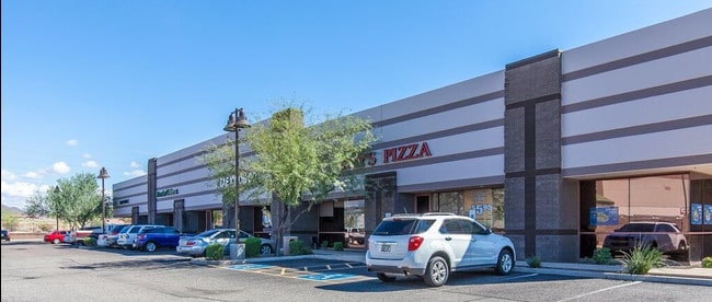
Property Detail
42201 N 41St Dr
203-03-012
ANTHEM COMMERCE PARK 33.2 MCR 537-26
Storebuilding
Maricopa
C-C
Arizona
C and X Area of minimal flood hazard, usually depicted on FIRMs as above the 500-year flood level.
2
2025
4.54 AC
2025
Anthem
610002
Phoenix
53,242 SF
Phoenix-Mesa-Chandler, AZ
NEARBY LISTINGS FOR SALE OR LEASE
DEMOGRAPHICS near 42201 N 41St Dr
1 mile
3 mile
5 mile
2025 Total Population
8,699
28,616
43,633
2030 Population
9,036
29,577
44,834
Pop Growth 2025-2030
+ 3.87%
+ 3.36%
+ 2.75%
Average Age
40
43
43
2025 Total Households
2,900
9,597
15,148
HH Growth 2025-2030
+ 3.76%
+ 3.16%
+ 2.55%
Median Household Inc
$110,175
$122,531
$124,683
Avg Household Size
2.90
2.80
2.70
2025 Avg HH Vehicles
2.00
2.00
2.00
Median Home Value
$549,220
$625,625
$642,814
Median Year Built
2005
2004
2004
Nearby Places
Map Layers
Map Styles
 Street
 Aerial
Layers
 Traffic
 Biking
Places
Listings with unknown addresses are not visible on the map
- Restaurants
- Banks
- Shops
- Fitness
- Groceries
SALE & LEASE HISTORY
LISTING DATE
SALE/LEASE

Sep 24, 2016
For Lease
Nearby Properties
Address
Land Use
TOTAL SIZE
Lot Size
Zoning
Address
Land Use
TOTAL SIZE
Lot Size
Zoning
41.99 AC
Address
Land Use
TOTAL SIZE
Lot Size
Zoning
306,185 SF
60 AC
R-2
Address
Land Use
TOTAL SIZE
Lot Size
Zoning
324,653 SF
48.16 AC
C-C
Address
Land Use
TOTAL SIZE
Lot Size
Zoning
390,032 SF
19.70 AC
M-H
Address
Land Use
TOTAL SIZE
Lot Size
Zoning
208,981 SF
22.09 AC
C-C
Address
Land Use
TOTAL SIZE
Lot Size
Zoning
86,142 SF
16.03 AC
R-7
Address
Land Use
TOTAL SIZE
Lot Size
Zoning
84,515 SF
14.14 AC
R-7
Address
Land Use
TOTAL SIZE
Lot Size
Zoning
10.25 AC
C2
Address
Land Use
TOTAL SIZE
Lot Size
Zoning
113,519 SF
12.18 AC
C-C
Address
Land Use
TOTAL SIZE
Lot Size
Zoning
79,802 SF
15 AC
R-6
Address
Land Use
TOTAL SIZE
Lot Size
Zoning
144,316 SF
6.40 AC
C-T
Address
Land Use
TOTAL SIZE
Lot Size
Zoning
54,866 SF
9.50 AC
C-C
Address
Land Use
TOTAL SIZE
Lot Size
Zoning
57,601 SF
8.16 AC
RU43
Address
Land Use
TOTAL SIZE
Lot Size
Zoning
119,647 SF
8.70 AC
R-8
Address
Land Use
TOTAL SIZE
Lot Size
Zoning
77,274 SF
7.34 AC
C-C
Address
Land Use
TOTAL SIZE
Lot Size
Zoning
119,810 SF
7.50 AC
C-T
Address
Land Use
TOTAL SIZE
Lot Size
Zoning
15,854 SF
24.69 AC
R-8
Address
Land Use
TOTAL SIZE
Lot Size
Zoning
44,055 SF
4.54 AC
C2
Address
Land Use
TOTAL SIZE
Lot Size
Zoning
44,502 SF
2.17 AC
C-C
Address
Land Use
TOTAL SIZE
Lot Size
Zoning
24,469 SF
3.53 AC
R-43AG
Address
Land Use
TOTAL SIZE
Lot Size
Zoning
35,503 SF
14.48 AC
C-C
Address
Land Use
TOTAL SIZE
Lot Size
Zoning
69,802 SF
5.21 AC
C-C
Address
Land Use
TOTAL SIZE
Lot Size
Zoning
18,486 SF
4.76 AC
R-7
Address
Land Use
TOTAL SIZE
Lot Size
Zoning
32,729 SF
4.10 AC
C-C
Address
Land Use
TOTAL SIZE
Lot Size
Zoning
31,077 SF
5.33 AC
C-C
Address
Land Use
TOTAL SIZE
Lot Size
Zoning
361 SF
51.66 AC
R-43AG
Address
Land Use
TOTAL SIZE
Lot Size
Zoning
20,782 SF
2.57 AC
C-T
The World's #1 Commercial Real Estate Marketplace
Connect with us
© 2026 CoStar Group
The information above has been obtained from sources believed reliable. While we do not doubt its accuracy we have not verified it and make no guarantee, warranty or representation about it. It is your responsibility to independently confirm its accuracy and completeness. Any projections, opinions, assumptions, or estimates used are for example only and do not represent the current or future performance of the property. The value of this transaction to you depends on tax and other factors which should be evaluated by your tax, financial, and legal advisors. You and your advisors should conduct a careful, independent investigation of the property to determine to your satisfaction the suitability of the property for your needs.