Property Record
4221 W Gulf To Lake Hwy, Lecanto, FL 34461
NEARBY LISTINGS FOR SALE OR LEASE
-
-
View all Lecanto listings for sale on LoopNet.com
Property Detail
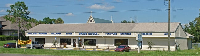
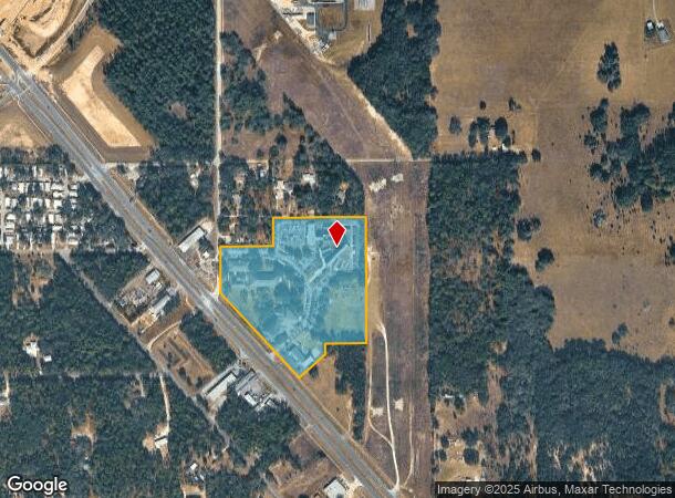
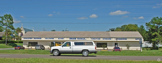
4221 W Gulf To Lake Hwy
Homosassa Springs, FL
Gaynor James A. (Ted)
18E-19S-05-0000-11000-0130
GAYNORS UNREC SUB LOT 13 14 15 16 17 18 19 20 21 22 23 24 25 26 27 29 30 31 & 32 SEC 5 TWN 19S RNG 18E MORE PART DESC AS FOLLOWS: LOT 13: COM NE COR SEC 5 TWN 19S RNG 18E; THN S 89 DEG 34M 42S W ALONG N LINE SAID SEC 5 1290.78 FT THN S 0 DEG 19M 38S
Religious
Citrus
X
Florida
12017C0307D
13
2024
18.52 AC
2025
Florida Central North Area
450306
Other Market Areas
98,289 SF
DEMOGRAPHICS near 4221 W Gulf To Lake Hwy
1 Mile
3 Mile
5 Mile
2024 Total Population
691
10,283
38,186
2029 Population
772
11,552
43,116
Pop Growth 2024-2029
+ 11.72%
+ 12.34%
+ 12.91%
Average Age
51
51
53
2024 Total Households
304
4,354
16,940
HH Growth 2024-2029
+ 11.18%
+ 12.01%
+ 12.64%
Median Household Inc
$54,347
$49,593
$48,524
Avg Household Size
2.10
2.20
2.10
2024 Avg HH Vehicles
2.00
2.00
2.00
Median Home Value
$216,981
$210,319
$213,071
Median Year Built
1991
1990
1989
Nearby Places
Map Layers
Map Styles
 Street
 Aerial
- Restaurants
- Banks
- Shops
- Fitness
- Groceries
Nearby Properties
Address
Land Use
TOTAL SIZE
Lot Size
Zoning
Address
Land Use
TOTAL SIZE
Lot Size
Zoning
982,616 SF
202.47 AC
PSI
Address
Land Use
TOTAL SIZE
Lot Size
Zoning
198,657 SF
73.75 AC
PSI
Address
Land Use
TOTAL SIZE
Lot Size
Zoning
113,920 SF
38.95 AC
PSI
Address
Land Use
TOTAL SIZE
Lot Size
Zoning
135,334 SF
11.45 AC
GNC
Address
Land Use
TOTAL SIZE
Lot Size
Zoning
901,824 SF
14.37 AC
GNC
Address
Land Use
TOTAL SIZE
Lot Size
Zoning
92,500 SF
5.11 AC
PSO
Address
Land Use
TOTAL SIZE
Lot Size
Zoning
198,628 SF
18.19 AC
LDRMH
Address
Land Use
TOTAL SIZE
Lot Size
Zoning
1,549.95 AC
CON
Address
Land Use
TOTAL SIZE
Lot Size
Zoning
104,427 SF
11.98 AC
MDR
Address
Land Use
TOTAL SIZE
Lot Size
Zoning
664,950 SF
20.21 AC
IND
Address
Land Use
TOTAL SIZE
Lot Size
Zoning
42,396 SF
20.02 AC
PSI
Address
Land Use
TOTAL SIZE
Lot Size
Zoning
98,862 SF
18.36 AC
RUR
Address
Land Use
TOTAL SIZE
Lot Size
Zoning
84,896 SF
23.49 AC
PSI
Address
Land Use
TOTAL SIZE
Lot Size
Zoning
57,652 SF
11.85 AC
GNC
Address
Land Use
TOTAL SIZE
Lot Size
Zoning
95,088 SF
103.82 AC
PSIMH
Address
Land Use
TOTAL SIZE
Lot Size
Zoning
55,949 SF
4.71 AC
GNC
Address
Land Use
TOTAL SIZE
Lot Size
Zoning
22.87 AC
GNC
Address
Land Use
TOTAL SIZE
Lot Size
Zoning
214,450 SF
9.18 AC
GNC
Address
Land Use
TOTAL SIZE
Lot Size
Zoning
42,134 SF
4.52 AC
GNC
Address
Land Use
TOTAL SIZE
Lot Size
Zoning
78,432 SF
18.88 AC
PSI
Address
Land Use
TOTAL SIZE
Lot Size
Zoning
54,753 SF
14.95 AC
PSI
Address
Land Use
TOTAL SIZE
Lot Size
Zoning
231,816 SF
7.30 AC
PDR
Address
Land Use
TOTAL SIZE
Lot Size
Zoning
36,430 SF
14.26 AC
GNC
Address
Land Use
TOTAL SIZE
Lot Size
Zoning
5,526 SF
4.72 AC
GNC
Address
Land Use
TOTAL SIZE
Lot Size
Zoning
20,492 SF
2.61 AC
GNC
Address
Land Use
TOTAL SIZE
Lot Size
Zoning
23,540 SF
8.97 AC
PSO
Address
Land Use
TOTAL SIZE
Lot Size
Zoning
47,636 SF
8.67 AC
PSO
Address
Land Use
TOTAL SIZE
Lot Size
Zoning
15.12 AC
GNC
Address
Land Use
TOTAL SIZE
Lot Size
Zoning
6,807 SF
3.64 AC
GNC
The World's #1 Commercial Real Estate Marketplace
Connect with us
© 2025 CoStar Group
The information above has been obtained from sources believed reliable. While we do not doubt its accuracy we have not verified it and make no guarantee, warranty or representation about it. It is your responsibility to independently confirm its accuracy and completeness. Any projections, opinions, assumptions, or estimates used are for example only and do not represent the current or future performance of the property. The value of this transaction to you depends on tax and other factors which should be evaluated by your tax, financial, and legal advisors. You and your advisors should conduct a careful, independent investigation of the property to determine to your satisfaction the suitability of the property for your needs.