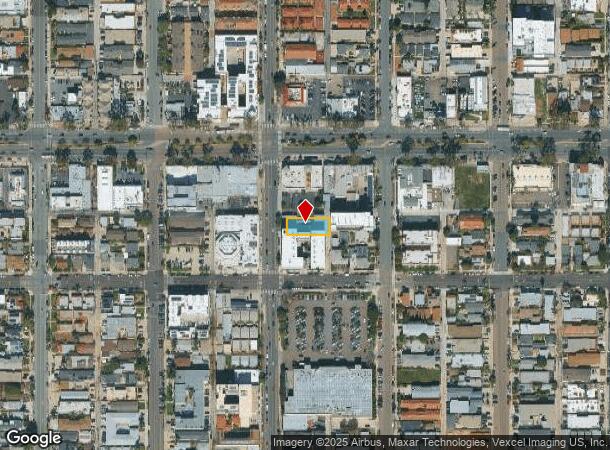
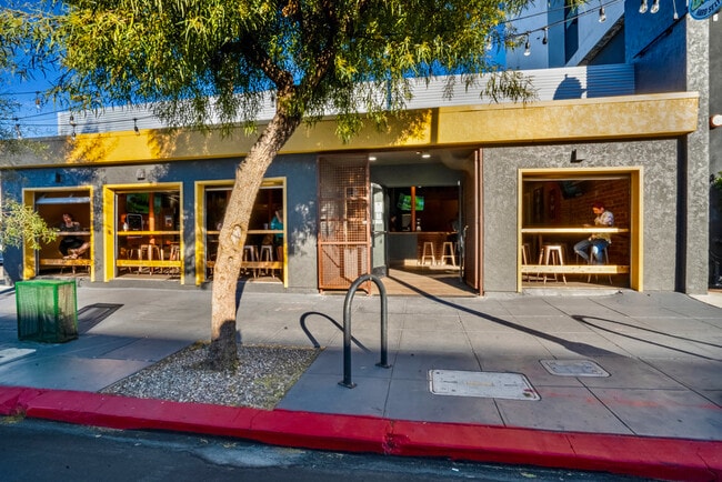
Property Record
4223 30Th St, San Diego, CA 92104

Current Lease Availabilities
NEARBY LISTINGS FOR SALE OR LEASE
Property Detail
4223 30Th St
San Diego-Carlsbad, CA
University Heights
446-233-13
BLK 118 LOTS 13 & 14 TR LP0008PG036
Storesoffices
San Diego
X
California
06073C1619G
13,14
2024
0.18 AC
2025
Central San Diego
001301
San Diego
5,845 SF
DEMOGRAPHICS near 4223 30Th St
1 Mile
3 Mile
5 Mile
2024 Total Population
54,053
263,571
590,448
2029 Population
54,026
263,201
588,978
Pop Growth 2024-2029
(0.05%)
(0.14%)
(0.25%)
Average Age
37
38
38
2024 Total Households
27,852
121,379
234,759
HH Growth 2024-2029
(0.21%)
(0.17%)
(0.17%)
Median Household Inc
$77,752
$76,978
$74,517
Avg Household Size
1.90
2.10
2.30
2024 Avg HH Vehicles
1.00
2.00
2.00
Median Home Value
$720,622
$749,627
$733,217
Median Year Built
1973
1973
1974
Nearby Places
- Restaurants
- Banks
- Shops
- Fitness
- Groceries
PUBLIC TRANSPORTATION
COMMUTER RAIL
San Diego (Santa Fe Depot) (Coaster - San Diego North County Transit District (Coaster/Sprinter/Breeze))
DRIVE
WALK
Distance
San Diego (Santa Fe Depot) (Coaster - San Diego North County Transit District (Coaster/Sprinter/Breeze))
9 min
4.9 mi
Old Town Transit Center (Coaster - San Diego North County Transit District (Coaster/Sprinter/Breeze))
DRIVE
WALK
Distance
Old Town Transit Center (Coaster - San Diego North County Transit District (Coaster/Sprinter/Breeze))
10 min
5.1 mi
AIRPORT
San Diego International
DRIVE
WALK
Distance
San Diego International
10 min
4.3 mi
Freight Ports
Port of San Diego
DRIVE
WALK
Distance
Port of San Diego
11 min
5.3 mi
Nearby Properties
Address
Land Use
TOTAL SIZE
Lot Size
Zoning
Address
Land Use
TOTAL SIZE
Lot Size
Zoning
30,000 SF
62.51 AC
MVPD-MV-CR
Address
Land Use
TOTAL SIZE
Lot Size
Zoning
4,774 SF
74.75 AC
RM-2-5
Address
Land Use
TOTAL SIZE
Lot Size
Zoning
1.38 AC
CCPD-R
Address
Land Use
TOTAL SIZE
Lot Size
Zoning
107.28 AC
UNZONED
Address
Land Use
TOTAL SIZE
Lot Size
Zoning
2.53 AC
EMX-1
Address
Land Use
TOTAL SIZE
Lot Size
Zoning
4.41 AC
CC-3-8
Address
Land Use
TOTAL SIZE
Lot Size
Zoning
1.51 AC
CC-3-9
Address
Land Use
TOTAL SIZE
Lot Size
Zoning
1.38 AC
CCPD-R
Address
Land Use
TOTAL SIZE
Lot Size
Zoning
RM-4-10
Address
Land Use
TOTAL SIZE
Lot Size
Zoning
6.96 AC
MVPD-MVR-4
Address
Land Use
TOTAL SIZE
Lot Size
Zoning
19.25 AC
CC-3-5
Address
Land Use
TOTAL SIZE
Lot Size
Zoning
15.37 AC
CC-3-8
Address
Land Use
TOTAL SIZE
Lot Size
Zoning
5.02 AC
CC-3-8
Address
Land Use
TOTAL SIZE
Lot Size
Zoning
54,240 SF
8.18 AC
MVPD-MVR-2
Address
Land Use
TOTAL SIZE
Lot Size
Zoning
2.50 AC
MVPD-MV-CO
Address
Land Use
TOTAL SIZE
Lot Size
Zoning
5.35 AC
MVPD-MV-CR
Address
Land Use
TOTAL SIZE
Lot Size
Zoning
3.97 AC
C
Address
Land Use
TOTAL SIZE
Lot Size
Zoning
7.69 AC
MVPD-MV-M/
Address
Land Use
TOTAL SIZE
Lot Size
Zoning
10,000 SF
0.36 AC
CCPD-ER
Address
Land Use
TOTAL SIZE
Lot Size
Zoning
13.04 AC
RM-2-5
Address
Land Use
TOTAL SIZE
Lot Size
Zoning
7.19 AC
MVPD-MV-M/
Address
Land Use
TOTAL SIZE
Lot Size
Zoning
17.35 AC
C-6
Address
Land Use
TOTAL SIZE
Lot Size
Zoning
902,919 SF
45.23 AC
MVPD-MV-CR
Address
Land Use
TOTAL SIZE
Lot Size
Zoning
2.90 AC
MVPD-MV-CR
Address
Land Use
TOTAL SIZE
Lot Size
Zoning
1.99 AC
EMX-1
Address
Land Use
TOTAL SIZE
Lot Size
Zoning
0.46 AC
CCPD-CORE
Address
Land Use
TOTAL SIZE
Lot Size
Zoning
1.81 AC
EMX-1
Address
Land Use
TOTAL SIZE
Lot Size
Zoning
6.68 AC
RM-3-7
Address
Land Use
TOTAL SIZE
Lot Size
Zoning
16.91 AC
EMX-1
Address
Land Use
TOTAL SIZE
Lot Size
Zoning
3.36 AC
RM-4-10
The World's #1 Commercial Real Estate Marketplace
Connect with us
© 2025 CoStar Group
The information above has been obtained from sources believed reliable. While we do not doubt its accuracy we have not verified it and make no guarantee, warranty or representation about it. It is your responsibility to independently confirm its accuracy and completeness. Any projections, opinions, assumptions, or estimates used are for example only and do not represent the current or future performance of the property. The value of this transaction to you depends on tax and other factors which should be evaluated by your tax, financial, and legal advisors. You and your advisors should conduct a careful, independent investigation of the property to determine to your satisfaction the suitability of the property for your needs.