Property Record
4224 N North Woods Trl, Hampstead, MD 21074

NEARBY LISTINGS FOR SALE OR LEASE
Property Detail
4224 N North Woods Trl
Baltimore-Columbia-Towson, MD
Right Of Way
08-043620
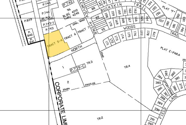
TRACT 5A- 1.149 ACS N WOODS TRL 40-62 RESUB ROBERTS FIELD BUS CNTR
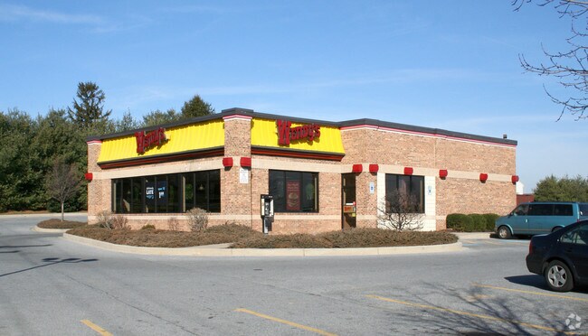
Restaurantdrivein
Carroll
X
Maryland
2400100080G
trc5a
2025
1.15 AC
2025
Carroll County
508103
Baltimore
3,714 SF
DEMOGRAPHICS near 4224 N North Woods Trl
1 Mile
3 Mile
5 Mile
2024 Total Population
5,262
12,633
24,382
2029 Population
5,414
12,919
24,754
Pop Growth 2024-2029
+ 2.89%
+ 2.26%
+ 1.53%
Average Age
40
41
42
2024 Total Households
2,097
4,859
9,170
HH Growth 2024-2029
+ 2.96%
+ 2.39%
+ 1.59%
Median Household Inc
$87,654
$92,020
$96,881
Avg Household Size
2.50
2.60
2.60
2024 Avg HH Vehicles
2.00
2.00
2.00
Median Home Value
$295,322
$339,578
$364,001
Median Year Built
1986
1984
1981
Nearby Places
Map Layers
Map Styles
 Street
 Aerial
- Restaurants
- Banks
- Shops
- Fitness
- Groceries
PUBLIC TRANSPORTATION
AIRPORT
Baltimore/Washington International Thurgood Marshall
DRIVE
WALK
Distance
Baltimore/Washington International Thurgood Marshall
51 min
33.3 mi
Freight Ports
Port of Baltimore
DRIVE
WALK
Distance
Port of Baltimore
51 min
33.6 mi
Nearby Properties
Address
Land Use
TOTAL SIZE
Lot Size
Zoning
Address
Land Use
TOTAL SIZE
Lot Size
Zoning
1,034,020 SF
51.58 AC
I-1
Address
Land Use
TOTAL SIZE
Lot Size
Zoning
842,295 SF
134.68 AC
RESTR
Address
Land Use
TOTAL SIZE
Lot Size
Zoning
223,105 SF
21.16 AC
RESTR
Address
Land Use
TOTAL SIZE
Lot Size
Zoning
115,358 SF
26.99 AC
PUBLI
Address
Land Use
TOTAL SIZE
Lot Size
Zoning
24,592 SF
1.17 AC
GLC3*
Address
Land Use
TOTAL SIZE
Lot Size
Zoning
58,095 SF
19.95 AC
Address
Land Use
TOTAL SIZE
Lot Size
Zoning
95,786 SF
10.11 AC
RESTR
Address
Land Use
TOTAL SIZE
Lot Size
Zoning
52,728 SF
13.88 AC
GENER
Address
Land Use
TOTAL SIZE
Lot Size
Zoning
210,288 SF
38.44 AC
RESTR
Address
Land Use
TOTAL SIZE
Lot Size
Zoning
229.22 AC
PUBLI
Address
Land Use
TOTAL SIZE
Lot Size
Zoning
39,992 SF
19.57 AC
PUBLI
Address
Land Use
TOTAL SIZE
Lot Size
Zoning
13,120 SF
3.15 AC
Address
Land Use
TOTAL SIZE
Lot Size
Zoning
3,000 SF
4.62 AC
I-1
Address
Land Use
TOTAL SIZE
Lot Size
Zoning
34,584 SF
6.02 AC
RESTR
Address
Land Use
TOTAL SIZE
Lot Size
Zoning
72,750 SF
7.09 AC
RESTR
Address
Land Use
TOTAL SIZE
Lot Size
Zoning
10,642 SF
2.30 AC
LOCAL
Address
Land Use
TOTAL SIZE
Lot Size
Zoning
7,696 SF
2.84 AC
GENER
Address
Land Use
TOTAL SIZE
Lot Size
Zoning
702 SF
34.80 AC
RESTR
Address
Land Use
TOTAL SIZE
Lot Size
Zoning
20,705 SF
182.66 AC
RC2
Address
Land Use
TOTAL SIZE
Lot Size
Zoning
260,550 SF
49.38 AC
HISTO
Address
Land Use
TOTAL SIZE
Lot Size
Zoning
52,824 SF
9.74 AC
GENER
Address
Land Use
TOTAL SIZE
Lot Size
Zoning
11,860 SF
1.64 AC
LOCAL
Address
Land Use
TOTAL SIZE
Lot Size
Zoning
3,820 SF
103 AC
R-750
Address
Land Use
TOTAL SIZE
Lot Size
Zoning
39.19 AC
RESTR
Address
Land Use
TOTAL SIZE
Lot Size
Zoning
13,657 SF
4.05 AC
PRIVA
Address
Land Use
TOTAL SIZE
Lot Size
Zoning
33,350 SF
3.50 AC
HISTO
Address
Land Use
TOTAL SIZE
Lot Size
Zoning
3,864 SF
4.87 AC
C-2
Address
Land Use
TOTAL SIZE
Lot Size
Zoning
9,100 SF
0.85 AC
GENER
Address
Land Use
TOTAL SIZE
Lot Size
Zoning
2,120 SF
1.10 AC
RES O
Address
Land Use
TOTAL SIZE
Lot Size
Zoning
10.75 AC
AGRIC
The World's #1 Commercial Real Estate Marketplace
Connect with us
© 2025 CoStar Group
The information above has been obtained from sources believed reliable. While we do not doubt its accuracy we have not verified it and make no guarantee, warranty or representation about it. It is your responsibility to independently confirm its accuracy and completeness. Any projections, opinions, assumptions, or estimates used are for example only and do not represent the current or future performance of the property. The value of this transaction to you depends on tax and other factors which should be evaluated by your tax, financial, and legal advisors. You and your advisors should conduct a careful, independent investigation of the property to determine to your satisfaction the suitability of the property for your needs.