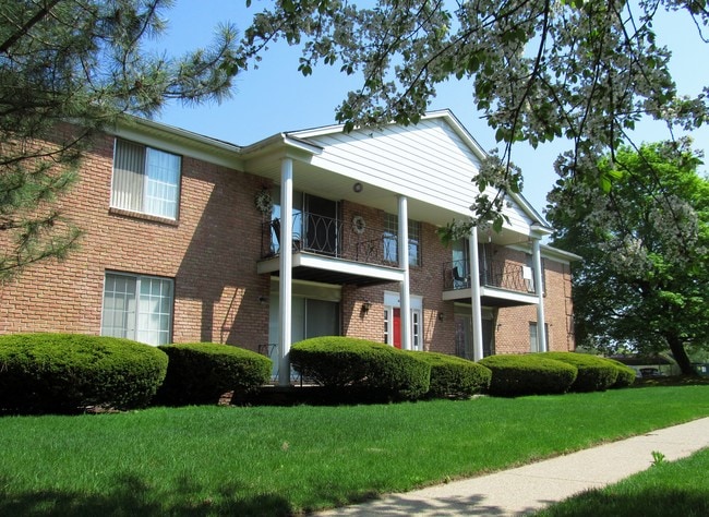
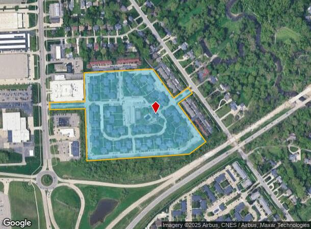
Property Record
42295 Parkside Cir, Sterling Heights, MI 48314

NEARBY LISTINGS FOR SALE OR LEASE
-
-
View all Sterling Heights listings for sale on LoopNet.com
Property Detail
42295 Parkside Cir
Detroit-Warren-Dearborn, MI
Sterling Plaza #2
10-10-10-152-023
T2N, R12E, SEC 10, COMM AT W 1/4 COR SEC 10; TH N88*12'00"E 460.23 FT TO POB; TH DUE N 990.83 FT; TH N88*30'44"E 781.09 FT;
Commercialnec
Macomb
X
Michigan
26099C0307G
39
2025
25.18 AC
2025
Sterling Heights
230501
Detroit
DEMOGRAPHICS near 42295 Parkside Cir
1 Mile
3 Mile
5 Mile
2024 Total Population
8,088
91,059
258,269
2029 Population
8,032
89,598
255,293
Pop Growth 2024-2029
(0.69%)
(1.60%)
(1.15%)
Average Age
39
42
42
2024 Total Households
3,446
36,264
103,134
HH Growth 2024-2029
(0.93%)
(1.68%)
(1.17%)
Median Household Inc
$63,798
$73,330
$73,903
Avg Household Size
2.30
2.40
2.40
2024 Avg HH Vehicles
2.00
2.00
2.00
Median Home Value
$213,688
$241,597
$243,376
Median Year Built
1971
1977
1979
Nearby Places
Map Layers
Map Styles
 Street
 Aerial
- Restaurants
- Banks
- Shops
- Fitness
- Groceries
PUBLIC TRANSPORTATION
AIRPORT
Windsor International
DRIVE
WALK
Distance
Windsor International
57 min
33.6 mi
Freight Ports
Port of Toledo
DRIVE
WALK
Distance
Port of Toledo
107 min
84.1 mi
Nearby Properties
Address
Land Use
TOTAL SIZE
Lot Size
Zoning
Address
Land Use
TOTAL SIZE
Lot Size
Zoning
920,611 SF
M-2
Address
Land Use
TOTAL SIZE
Lot Size
Zoning
1,024,233 SF
287.20 AC
M-2
Address
Land Use
TOTAL SIZE
Lot Size
Zoning
146.36 AC
MHP
Address
Land Use
TOTAL SIZE
Lot Size
Zoning
2,727,131 SF
155.26 AC
M-2
Address
Land Use
TOTAL SIZE
Lot Size
Zoning
92.30 AC
MHP
Address
Land Use
TOTAL SIZE
Lot Size
Zoning
2,058,062 SF
141.65 AC
M-2
Address
Land Use
TOTAL SIZE
Lot Size
Zoning
366,656 SF
30.08 AC
RM-2
Address
Land Use
TOTAL SIZE
Lot Size
Zoning
46.56 AC
CK MAP
Address
Land Use
TOTAL SIZE
Lot Size
Zoning
283,249 SF
M-2
Address
Land Use
TOTAL SIZE
Lot Size
Zoning
1,150 SF
25.68 AC
CK MAP
Address
Land Use
TOTAL SIZE
Lot Size
Zoning
2,984,492 SF
M-2
Address
Land Use
TOTAL SIZE
Lot Size
Zoning
423,027 SF
46.73 AC
M-1
Address
Land Use
TOTAL SIZE
Lot Size
Zoning
242,857 SF
9.61 AC
RM-3
Address
Land Use
TOTAL SIZE
Lot Size
Zoning
34.43 AC
CK MAP
Address
Land Use
TOTAL SIZE
Lot Size
Zoning
438,578 SF
36.60 AC
MXD
Address
Land Use
TOTAL SIZE
Lot Size
Zoning
23.78 AC
RML
Address
Land Use
TOTAL SIZE
Lot Size
Zoning
41.09 AC
R-7
Address
Land Use
TOTAL SIZE
Lot Size
Zoning
98,265 SF
7.04 AC
RM-2
Address
Land Use
TOTAL SIZE
Lot Size
Zoning
201,873 SF
M-1
Address
Land Use
TOTAL SIZE
Lot Size
Zoning
559,929 SF
41.57 AC
M-1
Address
Land Use
TOTAL SIZE
Lot Size
Zoning
148,330 SF
37.86 AC
RM-2
Address
Land Use
TOTAL SIZE
Lot Size
Zoning
255,070 SF
20.33 AC
RM-2
Address
Land Use
TOTAL SIZE
Lot Size
Zoning
237,108 SF
10.30 AC
R-12
Address
Land Use
TOTAL SIZE
Lot Size
Zoning
29.93 AC
RM-2
Address
Land Use
TOTAL SIZE
Lot Size
Zoning
210,000 SF
M-1
Address
Land Use
TOTAL SIZE
Lot Size
Zoning
29.39 AC
CK MAP
Address
Land Use
TOTAL SIZE
Lot Size
Zoning
159,750 SF
16.76 AC
M-1
Address
Land Use
TOTAL SIZE
Lot Size
Zoning
1,350 SF
21.90 AC
CK MAP
Address
Land Use
TOTAL SIZE
Lot Size
Zoning
554,374 SF
22.15 AC
M-2
The World's #1 Commercial Real Estate Marketplace
Connect with us
© 2026 CoStar Group
The information above has been obtained from sources believed reliable. While we do not doubt its accuracy we have not verified it and make no guarantee, warranty or representation about it. It is your responsibility to independently confirm its accuracy and completeness. Any projections, opinions, assumptions, or estimates used are for example only and do not represent the current or future performance of the property. The value of this transaction to you depends on tax and other factors which should be evaluated by your tax, financial, and legal advisors. You and your advisors should conduct a careful, independent investigation of the property to determine to your satisfaction the suitability of the property for your needs.