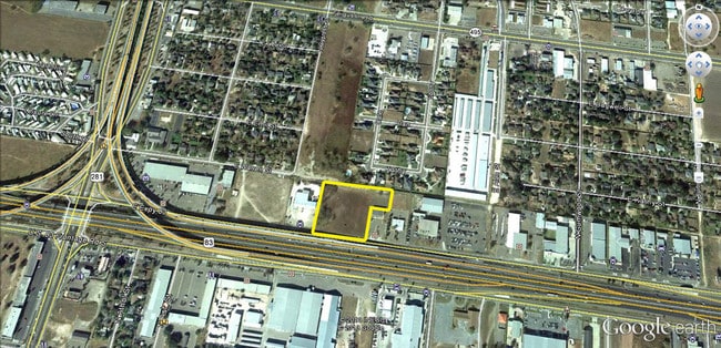
Property Record
423 E Interstate 2, Pharr, TX 78577

Property Detail
423 E Interstate 2
McAllen/Edinburg/Pharr
KELLY PHARR TRACT N339.02-E459.32-W659.32 EXC S249.63-E125 N OF EXPWY LOT 163 2.86AC NET
McAllen-Edinburg-Mission, TX
HIDALGO
K2400-00-000-0163-01
Texas
Vacantlandnec
163
2024
2.86 AC
2025
Pharr
021705
NEARBY LISTINGS FOR SALE OR LEASE
DEMOGRAPHICS near 423 E Interstate 2
1 mile
3 mile
5 mile
2025 Total Population
13,121
106,659
237,866
2030 Population
13,655
112,196
250,092
Pop Growth 2025-2030
+ 4.07%
+ 5.19%
+ 5.14%
Average Age
36
36
36
2025 Total Households
3,964
33,851
77,648
HH Growth 2025-2030
+ 3.96%
+ 5.39%
+ 5.21%
Median Household Inc
$42,348
$52,432
$54,620
Avg Household Size
3.20
3.00
3.00
2025 Avg HH Vehicles
2.00
2.00
2.00
Median Home Value
$85,619
$135,313
$158,269
Median Year Built
1988
1998
1997
Nearby Places
Map Layers
Map Styles
 Street
 Aerial
Transit
 Traffic
 Biking
Places
Listings with unknown addresses are not visible on the map
- Restaurants
- Banks
- Shops
- Fitness
- Groceries
PUBLIC TRANSPORTATION
AIRPORT
McAllen International
Drive
Walk
Distance
McAllen International
10 min
5.1 mi
Valley International
Drive
Walk
Distance
Valley International
55 min
38.0 mi
Freight Ports
Port of Brownsville
Drive
Walk
Distance
Port of Brownsville
64 min
56.3 mi
SALE & LEASE HISTORY
LISTING DATE
SALE/LEASE

Mar 31, 2017
For Sale
Jan 28, 2023
For Sale
Nearby Properties
Address
Land Use
TOTAL SIZE
Lot Size
Zoning
Address
Land Use
TOTAL SIZE
Lot Size
Zoning
390,048 SF
30.30 AC
Address
Land Use
TOTAL SIZE
Lot Size
Zoning
2 SF
38 AC
RS
Address
Land Use
TOTAL SIZE
Lot Size
Zoning
1 SF
9.36 AC
Address
Land Use
TOTAL SIZE
Lot Size
Zoning
175,594 SF
24.77 AC
Address
Land Use
TOTAL SIZE
Lot Size
Zoning
1 SF
39.94 AC
CO
Address
Land Use
TOTAL SIZE
Lot Size
Zoning
7.50 AC
Address
Land Use
TOTAL SIZE
Lot Size
Zoning
202,204 SF
19.43 AC
Address
Land Use
TOTAL SIZE
Lot Size
Zoning
15,542 SF
34.23 AC
Address
Land Use
TOTAL SIZE
Lot Size
Zoning
115,998 SF
6.73 AC
Address
Land Use
TOTAL SIZE
Lot Size
Zoning
140,904 SF
33.98 AC
Address
Land Use
TOTAL SIZE
Lot Size
Zoning
254,477 SF
51.88 AC
Address
Land Use
TOTAL SIZE
Lot Size
Zoning
79,150 SF
10.24 AC
Address
Land Use
TOTAL SIZE
Lot Size
Zoning
123,548 SF
10.70 AC
Address
Land Use
TOTAL SIZE
Lot Size
Zoning
135,948 SF
2.87 AC
Address
Land Use
TOTAL SIZE
Lot Size
Zoning
112,792 SF
29 AC
Address
Land Use
TOTAL SIZE
Lot Size
Zoning
2 SF
92.29 AC
CO
Address
Land Use
TOTAL SIZE
Lot Size
Zoning
121,353 SF
4.59 AC
Address
Land Use
TOTAL SIZE
Lot Size
Zoning
13,632 SF
17 AC
Address
Land Use
TOTAL SIZE
Lot Size
Zoning
66,605 SF
10.05 AC
Address
Land Use
TOTAL SIZE
Lot Size
Zoning
16.83 AC
CO
Address
Land Use
TOTAL SIZE
Lot Size
Zoning
208,104 SF
15.65 AC
Address
Land Use
TOTAL SIZE
Lot Size
Zoning
67,995 SF
21.10 AC
Address
Land Use
TOTAL SIZE
Lot Size
Zoning
143,400 SF
9.36 AC
Address
Land Use
TOTAL SIZE
Lot Size
Zoning
170,694 SF
27.21 AC
Address
Land Use
TOTAL SIZE
Lot Size
Zoning
145,326 SF
7.14 AC
Address
Land Use
TOTAL SIZE
Lot Size
Zoning
156,704 SF
7.06 AC
Address
Land Use
TOTAL SIZE
Lot Size
Zoning
29,172 SF
13.82 AC
Address
Land Use
TOTAL SIZE
Lot Size
Zoning
2 SF
22.11 AC
Address
Land Use
TOTAL SIZE
Lot Size
Zoning
2 SF
29.97 AC
Address
Land Use
TOTAL SIZE
Lot Size
Zoning
140,263 SF
14.83 AC
The World's #1 Commercial Real Estate Marketplace
Connect with us
© 2026 CoStar Group
The information above has been obtained from sources believed reliable. While we do not doubt its accuracy we have not verified it and make no guarantee, warranty or representation about it. It is your responsibility to independently confirm its accuracy and completeness. Any projections, opinions, assumptions, or estimates used are for example only and do not represent the current or future performance of the property. The value of this transaction to you depends on tax and other factors which should be evaluated by your tax, financial, and legal advisors. You and your advisors should conduct a careful, independent investigation of the property to determine to your satisfaction the suitability of the property for your needs.