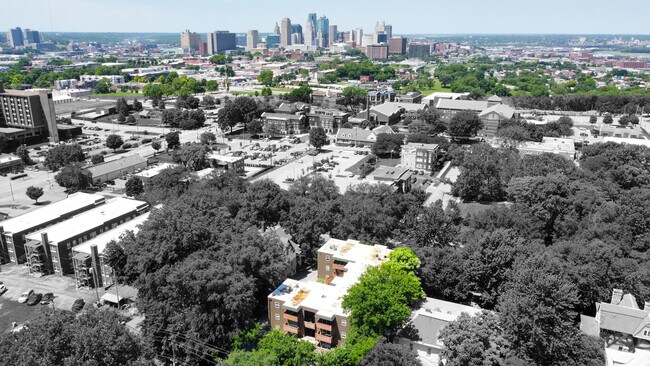
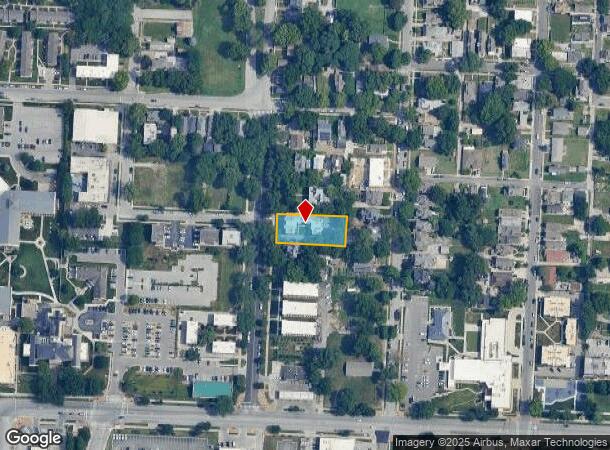
Property Record
423 Maple Blvd, Kansas City, MO 64124
NEARBY LISTINGS FOR SALE OR LEASE
Property Detail
423 Maple Blvd
Kansas City, MO-KS
Garfield Summit
12-740-37-10-00-0-00-000
SECTION 33 TWNSHP 50 RANGE 33 BEG ON E LI OF MAPLE BLVD 494. 5N OF N LI OF INDEP BLVD TH N 90 TH E 210 TH S 90 TH W 2 10 TO BEG
Apartment
Jackson
X
Missouri
29095C0256H
8-13
2024
0.43 AC
2025
Pendleton Heights
001000
Kansas City
10,076 SF
DEMOGRAPHICS near 423 Maple Blvd
1 Mile
3 Mile
5 Mile
2024 Total Population
17,572
96,959
221,232
2029 Population
18,071
99,516
225,893
Pop Growth 2024-2029
+ 2.84%
+ 2.64%
+ 2.11%
Average Age
35
36
37
2024 Total Households
7,175
42,309
96,784
HH Growth 2024-2029
+ 3.34%
+ 2.83%
+ 2.26%
Median Household Inc
$38,298
$47,237
$47,139
Avg Household Size
2.20
2.10
2.10
2024 Avg HH Vehicles
1.00
1.00
1.00
Median Home Value
$181,574
$137,653
$140,358
Median Year Built
1965
1955
1955
Nearby Places
Map Layers
Map Styles
 Street
 Aerial
- Restaurants
- Banks
- Shops
- Fitness
- Groceries
PUBLIC TRANSPORTATION
COMMUTER RAIL
DRIVE
WALK
Distance
8 min
3.5 mi
DRIVE
WALK
Distance
18 min
9.3 mi
AIRPORT
Kansas City International
DRIVE
WALK
Distance
Kansas City International
28 min
20.3 mi
SALE & LEASE HISTORY
LISTING DATE
SALE/LEASE

Nov 10, 2023
For Sale
May 06, 2023
For Sale
Apr 08, 2020
For Sale
Nearby Properties
Address
Land Use
TOTAL SIZE
Lot Size
Zoning
Address
Land Use
TOTAL SIZE
Lot Size
Zoning
Address
Land Use
TOTAL SIZE
Lot Size
Zoning
172,810 SF
Address
Land Use
TOTAL SIZE
Lot Size
Zoning
568,235 SF
9.59 AC
Address
Land Use
TOTAL SIZE
Lot Size
Zoning
488,351 SF
8.34 AC
Address
Land Use
TOTAL SIZE
Lot Size
Zoning
1,825,083 SF
25.77 AC
Address
Land Use
TOTAL SIZE
Lot Size
Zoning
8.29 AC
Address
Land Use
TOTAL SIZE
Lot Size
Zoning
63,748 SF
3.92 AC
Address
Land Use
TOTAL SIZE
Lot Size
Zoning
404,524 SF
5.51 AC
Address
Land Use
TOTAL SIZE
Lot Size
Zoning
711,196 SF
15.58 AC
Address
Land Use
TOTAL SIZE
Lot Size
Zoning
277,042 SF
0.40 AC
Address
Land Use
TOTAL SIZE
Lot Size
Zoning
257,647 SF
3.63 AC
Address
Land Use
TOTAL SIZE
Lot Size
Zoning
44,491 SF
1.96 AC
C3A2
Address
Land Use
TOTAL SIZE
Lot Size
Zoning
81,578 SF
1.63 AC
Address
Land Use
TOTAL SIZE
Lot Size
Zoning
115,627 SF
1.56 AC
Address
Land Use
TOTAL SIZE
Lot Size
Zoning
261,570 SF
1.82 AC
Address
Land Use
TOTAL SIZE
Lot Size
Zoning
Address
Land Use
TOTAL SIZE
Lot Size
Zoning
157,488 SF
1.60 AC
Address
Land Use
TOTAL SIZE
Lot Size
Zoning
87,294 SF
0.70 AC
Address
Land Use
TOTAL SIZE
Lot Size
Zoning
803,812 SF
5.85 AC
Address
Land Use
TOTAL SIZE
Lot Size
Zoning
384,543 SF
5.40 AC
Address
Land Use
TOTAL SIZE
Lot Size
Zoning
614,978 SF
31.56 AC
Address
Land Use
TOTAL SIZE
Lot Size
Zoning
274,622 SF
1.35 AC
Address
Land Use
TOTAL SIZE
Lot Size
Zoning
162,095 SF
Address
Land Use
TOTAL SIZE
Lot Size
Zoning
342,989 SF
1.84 AC
Address
Land Use
TOTAL SIZE
Lot Size
Zoning
238,003 SF
1.74 AC
Address
Land Use
TOTAL SIZE
Lot Size
Zoning
349,977 SF
2.21 AC
Address
Land Use
TOTAL SIZE
Lot Size
Zoning
191,753 SF
0.79 AC
M1
Address
Land Use
TOTAL SIZE
Lot Size
Zoning
27,292 SF
10.75 AC
Address
Land Use
TOTAL SIZE
Lot Size
Zoning
250,410 SF
3.74 AC
Address
Land Use
TOTAL SIZE
Lot Size
Zoning
131,115 SF
2.80 AC
The World's #1 Commercial Real Estate Marketplace
Connect with us
© 2025 CoStar Group
The information above has been obtained from sources believed reliable. While we do not doubt its accuracy we have not verified it and make no guarantee, warranty or representation about it. It is your responsibility to independently confirm its accuracy and completeness. Any projections, opinions, assumptions, or estimates used are for example only and do not represent the current or future performance of the property. The value of this transaction to you depends on tax and other factors which should be evaluated by your tax, financial, and legal advisors. You and your advisors should conduct a careful, independent investigation of the property to determine to your satisfaction the suitability of the property for your needs.