Property Record
423 N State St, Lockport, IL 60441
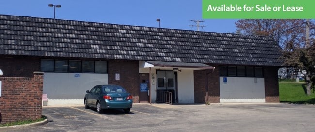
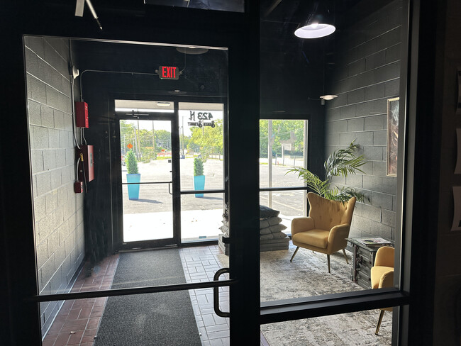
This Property Is For Sale
NEARBY LISTINGS FOR SALE OR LEASE
Property Detail
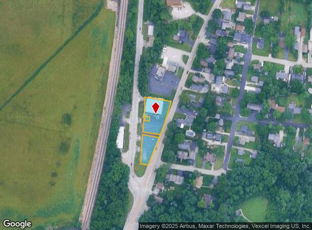
423 N State St
Chicago-Naperville-Elgin, IL-IN-WI
Runyon's Add
11-04-14-406-004
THAT PRT OF BLK 15 AND VACATED BLUFF ST AND THE N1/2 OF VACATED MARKET ST, LYG E OF THE E'LY ROW LN OF NEW AVE AND W OF THE W
Commercialnec
Will
X
Illinois
17197C0156G
0.87 AC
2024
Joliet Area
2024
Chicago
880502
DEMOGRAPHICS near 423 N State St
1 Mile
3 Mile
5 Mile
2024 Total Population
4,545
30,319
125,071
2029 Population
4,519
30,242
124,780
Pop Growth 2024-2029
(0.57%)
(0.25%)
(0.23%)
Average Age
41
40
40
2024 Total Households
1,871
11,318
44,081
HH Growth 2024-2029
(0.59%)
(0.28%)
(0.23%)
Median Household Inc
$77,350
$83,147
$78,550
Avg Household Size
2.40
2.60
2.70
2024 Avg HH Vehicles
2.00
2.00
2.00
Median Home Value
$226,306
$260,815
$243,177
Median Year Built
1960
1980
1990
Nearby Places
- Restaurants
- Banks
- Shops
- Fitness
- Groceries
PUBLIC TRANSPORTATION
COMMUTER RAIL
Lockport Station (Heritage Corridor Line - Northeast Illinois Regional Commuter Railroad (Metra))
DRIVE
WALK
Distance
Lockport Station (Heritage Corridor Line - Northeast Illinois Regional Commuter Railroad (Metra))
3 min
1.4 mi
Romeoville (Heritage Corridor - Metra)
DRIVE
WALK
Distance
Romeoville (Heritage Corridor - Metra)
7 min
3.5 mi
AIRPORT
Chicago Midway International
DRIVE
WALK
Distance
Chicago Midway International
34 min
24.5 mi
Chicago O'Hare International
DRIVE
WALK
Distance
Chicago O'Hare International
51 min
36.0 mi
Freight Ports
Port Milwaukee
DRIVE
WALK
Distance
Port Milwaukee
133 min
107.7 mi
Nearby Properties
Address
Land Use
TOTAL SIZE
Lot Size
Zoning
Address
Land Use
TOTAL SIZE
Lot Size
Zoning
80.44 AC
Address
Land Use
TOTAL SIZE
Lot Size
Zoning
52.19 AC
Address
Land Use
TOTAL SIZE
Lot Size
Zoning
39.75 AC
Address
Land Use
TOTAL SIZE
Lot Size
Zoning
50.08 AC
Address
Land Use
TOTAL SIZE
Lot Size
Zoning
24.65 AC
Address
Land Use
TOTAL SIZE
Lot Size
Zoning
35.45 AC
Address
Land Use
TOTAL SIZE
Lot Size
Zoning
33.95 AC
Address
Land Use
TOTAL SIZE
Lot Size
Zoning
30.56 AC
Address
Land Use
TOTAL SIZE
Lot Size
Zoning
19.21 AC
Address
Land Use
TOTAL SIZE
Lot Size
Zoning
17.18 AC
Address
Land Use
TOTAL SIZE
Lot Size
Zoning
28.08 AC
Address
Land Use
TOTAL SIZE
Lot Size
Zoning
23.12 AC
Address
Land Use
TOTAL SIZE
Lot Size
Zoning
22.59 AC
Address
Land Use
TOTAL SIZE
Lot Size
Zoning
25.79 AC
Address
Land Use
TOTAL SIZE
Lot Size
Zoning
Address
Land Use
TOTAL SIZE
Lot Size
Zoning
78.48 AC
Address
Land Use
TOTAL SIZE
Lot Size
Zoning
18.96 AC
Address
Land Use
TOTAL SIZE
Lot Size
Zoning
17.56 AC
Address
Land Use
TOTAL SIZE
Lot Size
Zoning
15.78 AC
Address
Land Use
TOTAL SIZE
Lot Size
Zoning
228,690 SF
17.80 AC
Address
Land Use
TOTAL SIZE
Lot Size
Zoning
Address
Land Use
TOTAL SIZE
Lot Size
Zoning
219,969 SF
23.30 AC
Address
Land Use
TOTAL SIZE
Lot Size
Zoning
128.58 AC
Address
Land Use
TOTAL SIZE
Lot Size
Zoning
80.92 AC
Address
Land Use
TOTAL SIZE
Lot Size
Zoning
228,690 SF
13.15 AC
Address
Land Use
TOTAL SIZE
Lot Size
Zoning
17.18 AC
Address
Land Use
TOTAL SIZE
Lot Size
Zoning
19.01 AC
Address
Land Use
TOTAL SIZE
Lot Size
Zoning
20.14 AC
Address
Land Use
TOTAL SIZE
Lot Size
Zoning
228,690 SF
10.54 AC
Address
Land Use
TOTAL SIZE
Lot Size
Zoning
136.20 AC
The World's #1 Commercial Real Estate Marketplace
Connect with us
© 2025 CoStar Group
The information above has been obtained from sources believed reliable. While we do not doubt its accuracy we have not verified it and make no guarantee, warranty or representation about it. It is your responsibility to independently confirm its accuracy and completeness. Any projections, opinions, assumptions, or estimates used are for example only and do not represent the current or future performance of the property. The value of this transaction to you depends on tax and other factors which should be evaluated by your tax, financial, and legal advisors. You and your advisors should conduct a careful, independent investigation of the property to determine to your satisfaction the suitability of the property for your needs.