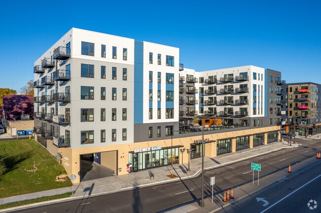
Property Record
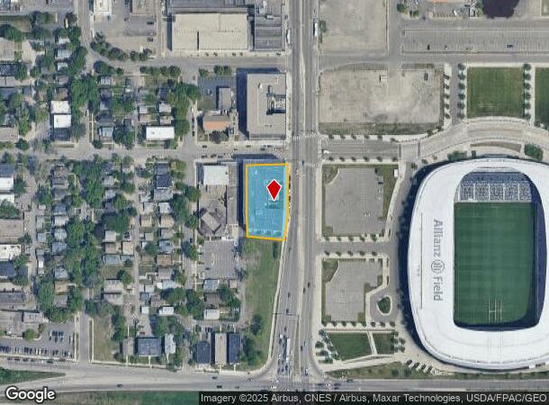
423 Snelling Ave N, Saint Paul, MN 55104
Current Lease Availabilities
NEARBY LISTINGS FOR SALE OR LEASE
Property Detail
423 Snelling Ave N
Minneapolis-St. Paul-Bloomington, MN-WI
Milham Park, Ramsey Co.,,Minn.
33-29-23-41-0132
MILHAM PARK, RAMSEY CO.,,MINN. VAC ALLEY ADJ AND ACCRUING AND SUBJ TO ...ESMTS; LOTS 1 THRU LOT 5 BLK 1
Apartment
Ramsey
X
Minnesota
27053C0400F
1
2024
0.70 AC
2025
Merriam Park East
033400
Minneapolis/St Paul
2,965 SF
DEMOGRAPHICS near 423 Snelling Ave N
1 Mile
3 Mile
5 Mile
2024 Total Population
24,100
166,924
426,304
2029 Population
23,575
162,707
418,083
Pop Growth 2024-2029
(2.18%)
(2.53%)
(1.93%)
Average Age
36
38
37
2024 Total Households
9,902
70,878
177,584
HH Growth 2024-2029
(2.34%)
(2.71%)
(1.98%)
Median Household Inc
$65,447
$72,277
$66,929
Avg Household Size
2.10
2.20
2.20
2024 Avg HH Vehicles
1.00
2.00
1.00
Median Home Value
$290,546
$335,761
$310,072
Median Year Built
1947
1948
1955
Nearby Places
- Restaurants
- Banks
- Shops
- Fitness
- Groceries
PUBLIC TRANSPORTATION
TRANSIT/SUBWAY
Snelling Ave Station (METRO Green Line - Metro Transit)
DRIVE
WALK
Distance
Snelling Ave Station (METRO Green Line - Metro Transit)
1 min
3 min
0.2 mi
Hamline Ave Station (METRO Green Line - Metro Transit)
DRIVE
WALK
Distance
Hamline Ave Station (METRO Green Line - Metro Transit)
2 min
11 min
0.6 mi
Fairview Ave Station (METRO Green Line - Metro Transit)
DRIVE
WALK
Distance
Fairview Ave Station (METRO Green Line - Metro Transit)
2 min
13 min
0.7 mi
COMMUTER RAIL
St. Paul-Minneapolis (Empire Builder - Amtrak)
DRIVE
WALK
Distance
St. Paul-Minneapolis (Empire Builder - Amtrak)
8 min
4.6 mi
Target Field Station (Northstar Corridor - Northstar Commuter Rail)
DRIVE
WALK
Distance
Target Field Station (Northstar Corridor - Northstar Commuter Rail)
13 min
6.6 mi
AIRPORT
Minneapolis-St Paul International/Wold-Chamberlain
DRIVE
WALK
Distance
Minneapolis-St Paul International/Wold-Chamberlain
15 min
7.4 mi
Freight Ports
Port Milwaukee
DRIVE
WALK
Distance
Port Milwaukee
367 min
332.9 mi
Nearby Properties
Address
Land Use
TOTAL SIZE
Lot Size
Zoning
Address
Land Use
TOTAL SIZE
Lot Size
Zoning
36,300 SF
223.37 AC
Address
Land Use
TOTAL SIZE
Lot Size
Zoning
141,277 SF
44.78 AC
Address
Land Use
TOTAL SIZE
Lot Size
Zoning
84,316 SF
40.83 AC
Address
Land Use
TOTAL SIZE
Lot Size
Zoning
504,049 SF
75.43 AC
Address
Land Use
TOTAL SIZE
Lot Size
Zoning
825,463 SF
7.04 AC
Address
Land Use
TOTAL SIZE
Lot Size
Zoning
124,932 SF
9.68 AC
Address
Land Use
TOTAL SIZE
Lot Size
Zoning
176,108 SF
27.45 AC
Address
Land Use
TOTAL SIZE
Lot Size
Zoning
577,656 SF
2.92 AC
C3A
Address
Land Use
TOTAL SIZE
Lot Size
Zoning
18.24 AC
Address
Land Use
TOTAL SIZE
Lot Size
Zoning
2.65 AC
Address
Land Use
TOTAL SIZE
Lot Size
Zoning
267,530 SF
28.60 AC
Address
Land Use
TOTAL SIZE
Lot Size
Zoning
546,882 SF
2.64 AC
R6
Address
Land Use
TOTAL SIZE
Lot Size
Zoning
395,419 SF
2.73 AC
Address
Land Use
TOTAL SIZE
Lot Size
Zoning
344,458 SF
1.64 AC
C3A
Address
Land Use
TOTAL SIZE
Lot Size
Zoning
3,200 SF
0.14 AC
Address
Land Use
TOTAL SIZE
Lot Size
Zoning
516,325 SF
16.81 AC
Address
Land Use
TOTAL SIZE
Lot Size
Zoning
4,808 SF
269.81 AC
Address
Land Use
TOTAL SIZE
Lot Size
Zoning
68,748 SF
21.59 AC
Address
Land Use
TOTAL SIZE
Lot Size
Zoning
18,630 SF
22.02 AC
Address
Land Use
TOTAL SIZE
Lot Size
Zoning
518,750 SF
3.58 AC
Address
Land Use
TOTAL SIZE
Lot Size
Zoning
291,264 SF
1.61 AC
C3A
Address
Land Use
TOTAL SIZE
Lot Size
Zoning
276,144 SF
347.68 AC
Address
Land Use
TOTAL SIZE
Lot Size
Zoning
245,477 SF
1.32 AC
C3A
Address
Land Use
TOTAL SIZE
Lot Size
Zoning
200,892 SF
3.60 AC
Address
Land Use
TOTAL SIZE
Lot Size
Zoning
445,437 SF
7.80 AC
Address
Land Use
TOTAL SIZE
Lot Size
Zoning
313,892 SF
2.03 AC
R5
Address
Land Use
TOTAL SIZE
Lot Size
Zoning
455,628 SF
2.81 AC
Address
Land Use
TOTAL SIZE
Lot Size
Zoning
251,619 SF
1.20 AC
Address
Land Use
TOTAL SIZE
Lot Size
Zoning
387,902 SF
14.81 AC
Address
Land Use
TOTAL SIZE
Lot Size
Zoning
318,765 SF
3.58 AC
The World's #1 Commercial Real Estate Marketplace
Connect with us
© 2025 CoStar Group
The information above has been obtained from sources believed reliable. While we do not doubt its accuracy we have not verified it and make no guarantee, warranty or representation about it. It is your responsibility to independently confirm its accuracy and completeness. Any projections, opinions, assumptions, or estimates used are for example only and do not represent the current or future performance of the property. The value of this transaction to you depends on tax and other factors which should be evaluated by your tax, financial, and legal advisors. You and your advisors should conduct a careful, independent investigation of the property to determine to your satisfaction the suitability of the property for your needs.