Property Record
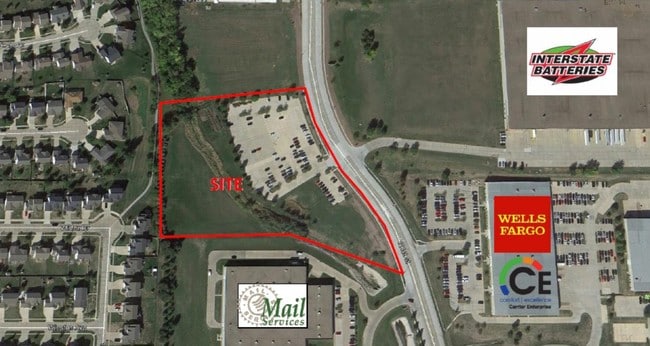
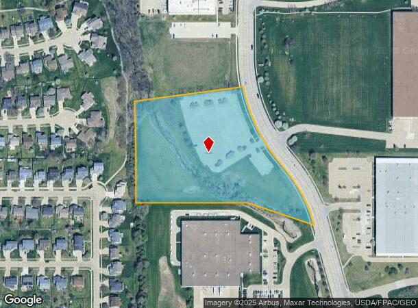
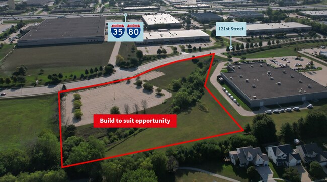
4230 121St St, Urbandale, IA 50323
This Property Is For Sale
Current Lease Availabilities
NEARBY LISTINGS FOR SALE OR LEASE
Property Detail
4230 121St St
Des Moines-West Des Moines, IA
Crossroads Business Pk Plat 2
312-00678022001
LT 9 & BEG 114.58F N OF SW COR THN N 435.49F NE 72.62F SE 358.16F SE 271.05F TO S COR LT 9 W 474.53F TO POB & BEG 18.17F NW OF SE COR THN NW 301.97F TO S COR LT 9 NE 214.01F SELY 264.11F TO POB LT 10 CROSSROADS BUSINESS PARK PLAT 2
Miscellaneous
Polk
A
Iowa
19153C0168F
9
2024
6.47 AC
2025
Western Suburbs
011304
Des Moines
9,880 SF
DEMOGRAPHICS near 4230 121St St
1 Mile
3 Mile
5 Mile
2024 Total Population
2,593
47,567
174,948
2029 Population
2,659
51,511
191,519
Pop Growth 2024-2029
+ 2.55%
+ 8.29%
+ 9.47%
Average Age
38
40
38
2024 Total Households
889
18,491
70,320
HH Growth 2024-2029
+ 2.70%
+ 8.09%
+ 9.61%
Median Household Inc
$221,486
$107,956
$89,446
Avg Household Size
2.90
2.50
2.50
2024 Avg HH Vehicles
2.00
2.00
2.00
Median Home Value
$329,856
$294,931
$273,097
Median Year Built
2005
1998
1995
Nearby Places
- Restaurants
- Banks
- Shops
- Fitness
- Groceries
PUBLIC TRANSPORTATION
AIRPORT
Des Moines International
DRIVE
WALK
Distance
Des Moines International
25 min
13.5 mi
Nearby Properties
Address
Land Use
TOTAL SIZE
Lot Size
Zoning
Address
Land Use
TOTAL SIZE
Lot Size
Zoning
472,476 SF
12.48 AC
PUD OFFICE
Address
Land Use
TOTAL SIZE
Lot Size
Zoning
18,093 SF
38.92 AC
Address
Land Use
TOTAL SIZE
Lot Size
Zoning
422,683 SF
46.57 AC
PCP
Address
Land Use
TOTAL SIZE
Lot Size
Zoning
457,056 SF
26.01 AC
Address
Land Use
TOTAL SIZE
Lot Size
Zoning
330,704 SF
15.86 AC
Address
Land Use
TOTAL SIZE
Lot Size
Zoning
407,183 SF
17.02 AC
PUD
Address
Land Use
TOTAL SIZE
Lot Size
Zoning
241,324 SF
21.67 AC
PUD B&C
Address
Land Use
TOTAL SIZE
Lot Size
Zoning
322,220 SF
7.61 AC
Address
Land Use
TOTAL SIZE
Lot Size
Zoning
275,227 SF
18.31 AC
PCP
Address
Land Use
TOTAL SIZE
Lot Size
Zoning
59,496 SF
9.34 AC
Address
Land Use
TOTAL SIZE
Lot Size
Zoning
196,904 SF
26.10 AC
PUD
Address
Land Use
TOTAL SIZE
Lot Size
Zoning
182,866 SF
10.21 AC
Address
Land Use
TOTAL SIZE
Lot Size
Zoning
300,000 SF
17.51 AC
Address
Land Use
TOTAL SIZE
Lot Size
Zoning
572,809 SF
42.13 AC
M-2
Address
Land Use
TOTAL SIZE
Lot Size
Zoning
367,386 SF
24.31 AC
PUD
Address
Land Use
TOTAL SIZE
Lot Size
Zoning
270,000 SF
19.10 AC
Address
Land Use
TOTAL SIZE
Lot Size
Zoning
133,256 SF
15.93 AC
Address
Land Use
TOTAL SIZE
Lot Size
Zoning
151,344 SF
10.43 AC
C-3
Address
Land Use
TOTAL SIZE
Lot Size
Zoning
260,000 SF
14.32 AC
Address
Land Use
TOTAL SIZE
Lot Size
Zoning
83,370 SF
0.98 AC
C-3
Address
Land Use
TOTAL SIZE
Lot Size
Zoning
79,916 SF
7.82 AC
PUD OFFICE
Address
Land Use
TOTAL SIZE
Lot Size
Zoning
260,000 SF
18.45 AC
Address
Land Use
TOTAL SIZE
Lot Size
Zoning
235,422 SF
13.39 AC
Address
Land Use
TOTAL SIZE
Lot Size
Zoning
250,000 SF
13.93 AC
Address
Land Use
TOTAL SIZE
Lot Size
Zoning
80,045 SF
5.07 AC
C-3
Address
Land Use
TOTAL SIZE
Lot Size
Zoning
245,520 SF
19.33 AC
Address
Land Use
TOTAL SIZE
Lot Size
Zoning
168,898 SF
17.54 AC
PUD
Address
Land Use
TOTAL SIZE
Lot Size
Zoning
212,500 SF
10.20 AC
Address
Land Use
TOTAL SIZE
Lot Size
Zoning
94,136 SF
18.48 AC
PUD
Address
Land Use
TOTAL SIZE
Lot Size
Zoning
66,708 SF
9.75 AC
The World's #1 Commercial Real Estate Marketplace
Connect with us
© 2025 CoStar Group
The information above has been obtained from sources believed reliable. While we do not doubt its accuracy we have not verified it and make no guarantee, warranty or representation about it. It is your responsibility to independently confirm its accuracy and completeness. Any projections, opinions, assumptions, or estimates used are for example only and do not represent the current or future performance of the property. The value of this transaction to you depends on tax and other factors which should be evaluated by your tax, financial, and legal advisors. You and your advisors should conduct a careful, independent investigation of the property to determine to your satisfaction the suitability of the property for your needs.