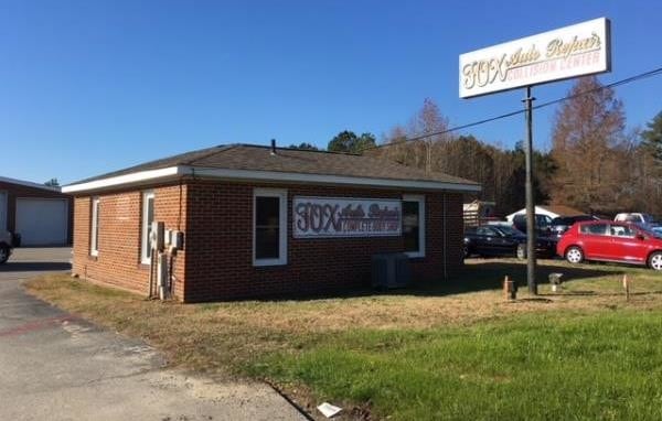
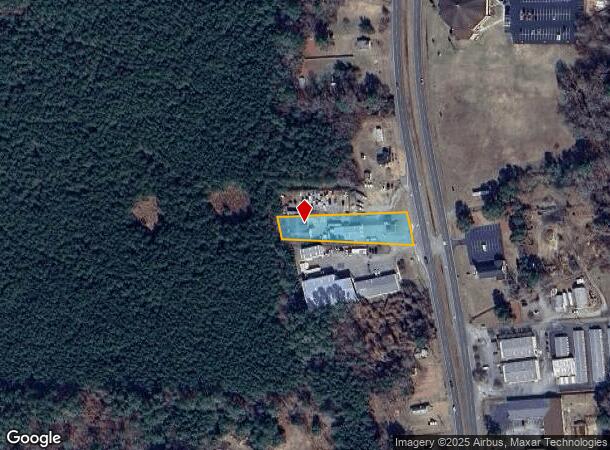
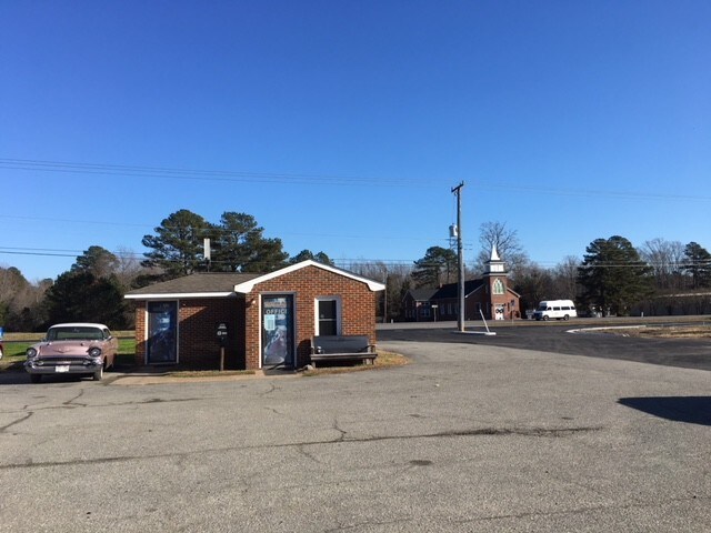
Property Record
4230 George Washington Memorial Hwy, Hayes, VA 23072
NEARBY LISTINGS FOR SALE OR LEASE
Property Detail
4230 George Washington Memorial Hwy
29028
Plat: Pb3 49
Officebuilding
ORDINARY
X
Gloucester
51073C0185F
Virginia
2025
0.85 AC
2025
Gloucester
100302
Hampton Roads
481 SF
Virginia Beach-Norfolk-Newport News, VA-NC
DEMOGRAPHICS near 4230 George Washington Memorial Hwy
1 Mile
3 Mile
5 Mile
2024 Total Population
1,187
6,760
17,095
2029 Population
1,227
6,955
17,754
Pop Growth 2024-2029
+ 3.37%
+ 2.88%
+ 3.85%
Average Age
39
42
43
2024 Total Households
422
2,693
7,015
HH Growth 2024-2029
+ 3.32%
+ 2.82%
+ 3.76%
Median Household Inc
$85,022
$77,815
$75,382
Avg Household Size
2.80
2.50
2.40
2024 Avg HH Vehicles
3.00
3.00
2.00
Median Home Value
$306,780
$270,715
$277,246
Median Year Built
1991
1986
1983
Nearby Places
Map Layers
Map Styles
 Street
 Aerial
- Restaurants
- Banks
- Shops
- Fitness
- Groceries
PUBLIC TRANSPORTATION
AIRPORT
Newport News/Williamsburg International
DRIVE
WALK
Distance
Newport News/Williamsburg International
26 min
16.1 mi
Freight Ports
Virginia Port Authority - Newport News
DRIVE
WALK
Distance
Virginia Port Authority - Newport News
44 min
29.4 mi
SALE & LEASE HISTORY
LISTING DATE
SALE/LEASE

Jan 08, 2018
For Sale
Nearby Properties
Address
Land Use
TOTAL SIZE
Lot Size
Zoning
Address
Land Use
TOTAL SIZE
Lot Size
Zoning
35,711 SF
136.70 AC
SC-1
Address
Land Use
TOTAL SIZE
Lot Size
Zoning
1,876 SF
643 AC
SC-1
Address
Land Use
TOTAL SIZE
Lot Size
Zoning
86,535 SF
9.63 AC
SF-1
Address
Land Use
TOTAL SIZE
Lot Size
Zoning
37,510 SF
11.59 AC
B-1
Address
Land Use
TOTAL SIZE
Lot Size
Zoning
16,048 SF
9.90 AC
B-1
Address
Land Use
TOTAL SIZE
Lot Size
Zoning
5,850 SF
5.28 AC
B-1
Address
Land Use
TOTAL SIZE
Lot Size
Zoning
18,524 SF
6.78 AC
B-1
Address
Land Use
TOTAL SIZE
Lot Size
Zoning
891 SF
33.83 AC
I-1
Address
Land Use
TOTAL SIZE
Lot Size
Zoning
27,175 SF
9.56 AC
SF-1
Address
Land Use
TOTAL SIZE
Lot Size
Zoning
11,776 SF
29.96 AC
RC-2
Address
Land Use
TOTAL SIZE
Lot Size
Zoning
40,720 SF
1.23 AC
B-1
Address
Land Use
TOTAL SIZE
Lot Size
Zoning
7,054 SF
3.91 AC
B-1
Address
Land Use
TOTAL SIZE
Lot Size
Zoning
2,554 SF
2.54 AC
B-2
Address
Land Use
TOTAL SIZE
Lot Size
Zoning
3,360 SF
7.22 AC
MF-1
Address
Land Use
TOTAL SIZE
Lot Size
Zoning
11,152 SF
5 AC
SF-1
Address
Land Use
TOTAL SIZE
Lot Size
Zoning
7,800 SF
15.52 AC
SC-1
Address
Land Use
TOTAL SIZE
Lot Size
Zoning
21.02 AC
C-2
Address
Land Use
TOTAL SIZE
Lot Size
Zoning
4.33 AC
B-1
Address
Land Use
TOTAL SIZE
Lot Size
Zoning
5,858 SF
2.93 AC
B-1
Address
Land Use
TOTAL SIZE
Lot Size
Zoning
274.41 AC
SC-1
Address
Land Use
TOTAL SIZE
Lot Size
Zoning
5.01 AC
SC-1
Address
Land Use
TOTAL SIZE
Lot Size
Zoning
2,268 SF
19.22 AC
C-2
Address
Land Use
TOTAL SIZE
Lot Size
Zoning
2,700 SF
8 AC
B-1
Address
Land Use
TOTAL SIZE
Lot Size
Zoning
10.14 AC
SF-1
Address
Land Use
TOTAL SIZE
Lot Size
Zoning
8,486 SF
7.31 AC
B-1
Address
Land Use
TOTAL SIZE
Lot Size
Zoning
374.45 AC
RC-2
Address
Land Use
TOTAL SIZE
Lot Size
Zoning
8.67 AC
SF-1
Address
Land Use
TOTAL SIZE
Lot Size
Zoning
9,000 SF
4.44 AC
B-1
Address
Land Use
TOTAL SIZE
Lot Size
Zoning
4,000 SF
4.26 AC
B-1
Address
Land Use
TOTAL SIZE
Lot Size
Zoning
1,248 SF
7.13 AC
SF-1
The World's #1 Commercial Real Estate Marketplace
Connect with us
© 2025 CoStar Group
The information above has been obtained from sources believed reliable. While we do not doubt its accuracy we have not verified it and make no guarantee, warranty or representation about it. It is your responsibility to independently confirm its accuracy and completeness. Any projections, opinions, assumptions, or estimates used are for example only and do not represent the current or future performance of the property. The value of this transaction to you depends on tax and other factors which should be evaluated by your tax, financial, and legal advisors. You and your advisors should conduct a careful, independent investigation of the property to determine to your satisfaction the suitability of the property for your needs.