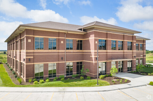
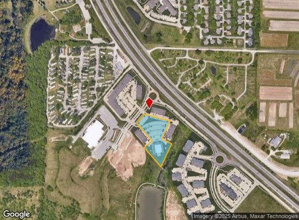
Property Record
4230 Philips Farm Rd, Columbia, MO 65201

NEARBY LISTINGS FOR SALE OR LEASE
Property Detail
4230 Philips Farm Rd
Columbia, MO
Discovery Park Subdivision
17-704-00-07-002-00-01
DISCOVERY PARK SUBDIVISION PLAT 2-B LOT 2A
Officebuilding
Boone
X
Missouri
29019C0295E
2
2025
3.34 AC
2025
Columbia/Jefferson City
001106
Other Market Areas
30,780 SF
DEMOGRAPHICS near 4230 Philips Farm Rd
1 Mile
3 Mile
5 Mile
2024 Total Population
5,542
28,514
86,028
2029 Population
5,963
30,378
91,178
Pop Growth 2024-2029
+ 7.60%
+ 6.54%
+ 5.99%
Average Age
35
33
34
2024 Total Households
2,385
12,134
34,867
HH Growth 2024-2029
+ 7.51%
+ 6.77%
+ 6.45%
Median Household Inc
$53,794
$49,805
$48,846
Avg Household Size
2.20
2.10
2.10
2024 Avg HH Vehicles
2.00
2.00
2.00
Median Home Value
$175,565
$204,344
$252,396
Median Year Built
2009
1996
1991
Nearby Places
Map Layers
Map Styles
 Street
 Aerial
- Restaurants
- Banks
- Shops
- Fitness
- Groceries
PUBLIC TRANSPORTATION
AIRPORT
Columbia Regional
DRIVE
WALK
Distance
Columbia Regional
13 min
8.5 mi
Freight Ports
Tulsa Port of Inola
DRIVE
WALK
Distance
Tulsa Port of Inola
374 min
331.2 mi
SALE & LEASE HISTORY
LISTING DATE
SALE/LEASE

Oct 11, 2019
For Lease
Nearby Properties
Address
Land Use
TOTAL SIZE
Lot Size
Zoning
Address
Land Use
TOTAL SIZE
Lot Size
Zoning
373,370 SF
77.30 AC
O1
Address
Land Use
TOTAL SIZE
Lot Size
Zoning
149,686 SF
15.26 AC
MC
Address
Land Use
TOTAL SIZE
Lot Size
Zoning
6,390 SF
28.23 AC
Address
Land Use
TOTAL SIZE
Lot Size
Zoning
10,459 SF
39.22 AC
RMH
Address
Land Use
TOTAL SIZE
Lot Size
Zoning
50,304 SF
8.78 AC
C1
Address
Land Use
TOTAL SIZE
Lot Size
Zoning
11,760 SF
22.98 AC
Address
Land Use
TOTAL SIZE
Lot Size
Zoning
52,568 SF
9.50 AC
Address
Land Use
TOTAL SIZE
Lot Size
Zoning
70,930 SF
9.66 AC
Address
Land Use
TOTAL SIZE
Lot Size
Zoning
185,585 SF
18.57 AC
Address
Land Use
TOTAL SIZE
Lot Size
Zoning
3,420 SF
18.60 AC
R3
Address
Land Use
TOTAL SIZE
Lot Size
Zoning
8,678 SF
23.15 AC
R3
Address
Land Use
TOTAL SIZE
Lot Size
Zoning
264,960 SF
40.01 AC
R1
Address
Land Use
TOTAL SIZE
Lot Size
Zoning
148,500 SF
22.62 AC
R3
Address
Land Use
TOTAL SIZE
Lot Size
Zoning
119,520 SF
12.56 AC
Address
Land Use
TOTAL SIZE
Lot Size
Zoning
34,357 SF
15.59 AC
Address
Land Use
TOTAL SIZE
Lot Size
Zoning
119,988 SF
8.87 AC
Address
Land Use
TOTAL SIZE
Lot Size
Zoning
136,851 SF
2.23 AC
CP
Address
Land Use
TOTAL SIZE
Lot Size
Zoning
2,922 SF
11.40 AC
PUD1
Address
Land Use
TOTAL SIZE
Lot Size
Zoning
159,984 SF
15.20 AC
R3
Address
Land Use
TOTAL SIZE
Lot Size
Zoning
31,200 SF
14.84 AC
Address
Land Use
TOTAL SIZE
Lot Size
Zoning
13,024 SF
11.90 AC
R3
Address
Land Use
TOTAL SIZE
Lot Size
Zoning
176,300 SF
5.22 AC
Address
Land Use
TOTAL SIZE
Lot Size
Zoning
11.48 AC
Address
Land Use
TOTAL SIZE
Lot Size
Zoning
77,804 SF
7.77 AC
Address
Land Use
TOTAL SIZE
Lot Size
Zoning
3,875 SF
15.03 AC
A1
Address
Land Use
TOTAL SIZE
Lot Size
Zoning
94,185 SF
3.19 AC
C3
Address
Land Use
TOTAL SIZE
Lot Size
Zoning
83,119 SF
6.48 AC
C1
Address
Land Use
TOTAL SIZE
Lot Size
Zoning
68,477 SF
3.55 AC
Address
Land Use
TOTAL SIZE
Lot Size
Zoning
5,920 SF
8.91 AC
R3
Address
Land Use
TOTAL SIZE
Lot Size
Zoning
96,322 SF
9.40 AC
The World's #1 Commercial Real Estate Marketplace
Connect with us
© 2026 CoStar Group
The information above has been obtained from sources believed reliable. While we do not doubt its accuracy we have not verified it and make no guarantee, warranty or representation about it. It is your responsibility to independently confirm its accuracy and completeness. Any projections, opinions, assumptions, or estimates used are for example only and do not represent the current or future performance of the property. The value of this transaction to you depends on tax and other factors which should be evaluated by your tax, financial, and legal advisors. You and your advisors should conduct a careful, independent investigation of the property to determine to your satisfaction the suitability of the property for your needs.