Property Record
4230 Us 27 N, Sebring, FL 33870
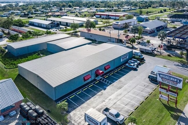


Property Detail
4230 Us 27 N
S-14-34-28-040-0000-04A0
NORTHWOOD SUB PB 13 PG 70 LOTS 4A + 5A
Storemultistory
HIGHLANDS
C1
Florida
B and X Area of moderate flood hazard, usually the area between the limits of the 100-year and 500-year floods.
4a,5a
2025
1.54 AC
2025
Florida Central South Area
960104
Other Market Areas
11,500 SF
Sebring, FL
NEARBY LISTINGS FOR SALE OR LEASE
DEMOGRAPHICS near 4230 Us 27 N
1 mile
3 mile
5 mile
2025 Total Population
5,619
24,528
47,651
2030 Population
5,991
26,202
50,959
Pop Growth 2025-2030
+ 6.62%
+ 6.82%
+ 6.94%
Average Age
55
52
51
2025 Total Households
2,688
11,151
21,537
HH Growth 2025-2030
+ 6.73%
+ 6.93%
+ 7.11%
Median Household Inc
$57,218
$60,734
$54,102
Avg Household Size
2.00
2.10
2.10
2025 Avg HH Vehicles
1.00
2.00
2.00
Median Home Value
$137,423
$201,789
$195,181
Median Year Built
1989
1987
1985
Nearby Places
Map Layers
Map Styles
 Street
 Aerial
Layers
 Traffic
 Biking
Places
Listings with unknown addresses are not visible on the map
- Restaurants
- Banks
- Shops
- Fitness
- Groceries
PUBLIC TRANSPORTATION
COMMUTER RAIL
Drive
Walk
Distance
11 min
5.0 mi
Nearby Properties
Address
Land Use
TOTAL SIZE
Lot Size
Zoning
Address
Land Use
TOTAL SIZE
Lot Size
Zoning
319,284 SF
76.37 AC
P
Address
Land Use
TOTAL SIZE
Lot Size
Zoning
235,165 SF
33.99 AC
B3
Address
Land Use
TOTAL SIZE
Lot Size
Zoning
155,486 SF
21.71 AC
C1
Address
Land Use
TOTAL SIZE
Lot Size
Zoning
118,053 SF
21.01 AC
P
Address
Land Use
TOTAL SIZE
Lot Size
Zoning
116,629 SF
19.72 AC
EU
Address
Land Use
TOTAL SIZE
Lot Size
Zoning
91,625 SF
5 AC
R3
Address
Land Use
TOTAL SIZE
Lot Size
Zoning
176,175 SF
22.73 AC
C1
Address
Land Use
TOTAL SIZE
Lot Size
Zoning
104,876 SF
33.52 AC
B3
Address
Land Use
TOTAL SIZE
Lot Size
Zoning
62,304 SF
6.18 AC
B3
Address
Land Use
TOTAL SIZE
Lot Size
Zoning
320 SF
10.93 AC
C1
Address
Land Use
TOTAL SIZE
Lot Size
Zoning
23,187 SF
0.68 AC
P
Address
Land Use
TOTAL SIZE
Lot Size
Zoning
137,240 SF
14.46 AC
B3
Address
Land Use
TOTAL SIZE
Lot Size
Zoning
119,540 SF
15.17 AC
B3
Address
Land Use
TOTAL SIZE
Lot Size
Zoning
71,609 SF
15.32 AC
P
Address
Land Use
TOTAL SIZE
Lot Size
Zoning
46,625 SF
6.45 AC
R3FUD
Address
Land Use
TOTAL SIZE
Lot Size
Zoning
39,144 SF
1.67 AC
C1
Address
Land Use
TOTAL SIZE
Lot Size
Zoning
102,610 SF
5.06 AC
C1
Address
Land Use
TOTAL SIZE
Lot Size
Zoning
55,344 SF
8.15 AC
C1
Address
Land Use
TOTAL SIZE
Lot Size
Zoning
26,587 SF
1.80 AC
B3
Address
Land Use
TOTAL SIZE
Lot Size
Zoning
68,140 SF
6.66 AC
B3
Address
Land Use
TOTAL SIZE
Lot Size
Zoning
28,628 SF
4.22 AC
B3
Address
Land Use
TOTAL SIZE
Lot Size
Zoning
17,006 SF
2.59 AC
B2
Address
Land Use
TOTAL SIZE
Lot Size
Zoning
22,340 SF
2.22 AC
C1
Address
Land Use
TOTAL SIZE
Lot Size
Zoning
29,041 SF
1.39 AC
B2CU
Address
Land Use
TOTAL SIZE
Lot Size
Zoning
30,165 SF
2.89 AC
R1A
Address
Land Use
TOTAL SIZE
Lot Size
Zoning
19,043 SF
6.67 AC
B4FUD
Address
Land Use
TOTAL SIZE
Lot Size
Zoning
24,755 SF
2.61 AC
R3
Address
Land Use
TOTAL SIZE
Lot Size
Zoning
17,762 SF
1.52 AC
R1A
Address
Land Use
TOTAL SIZE
Lot Size
Zoning
19,500 SF
19.07 AC
I1
Address
Land Use
TOTAL SIZE
Lot Size
Zoning
6,600 SF
0.99 AC
B3
The World's #1 Commercial Real Estate Marketplace
Connect with us
© 2026 CoStar Group
The information above has been obtained from sources believed reliable. While we do not doubt its accuracy we have not verified it and make no guarantee, warranty or representation about it. It is your responsibility to independently confirm its accuracy and completeness. Any projections, opinions, assumptions, or estimates used are for example only and do not represent the current or future performance of the property. The value of this transaction to you depends on tax and other factors which should be evaluated by your tax, financial, and legal advisors. You and your advisors should conduct a careful, independent investigation of the property to determine to your satisfaction the suitability of the property for your needs.