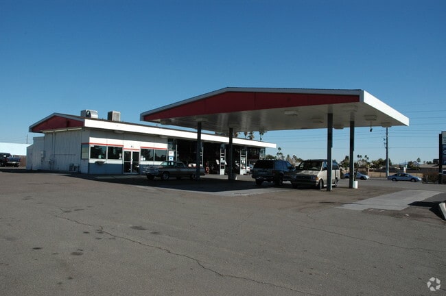
Property Record
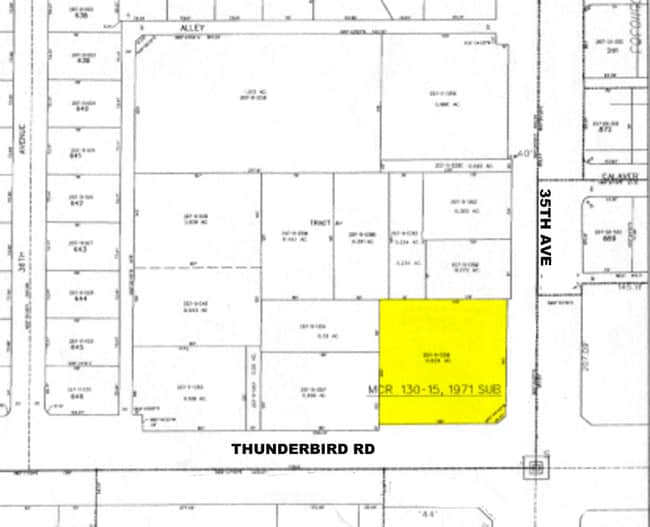
42302 N Vision Way, Phoenix, AZ 85086
NEARBY LISTINGS FOR SALE OR LEASE
Property Detail
42302 N Vision Way
Phoenix-Mesa-Scottsdale, AZ
Anthem Commerce Park 33.2
203-03-037
DEERVIEW UNIT 7 MCR 130-15
Warehouse
Maricopa
X
Arizona
04013C0835L
a
2025
2.52 AC
2025
N Phoenix/I-17 Corr
104202
Phoenix
37,155 SF
DEMOGRAPHICS near 42302 N Vision Way
1 Mile
3 Mile
5 Mile
2024 Total Population
21,127
148,283
407,139
2029 Population
22,793
160,103
438,965
Pop Growth 2024-2029
+ 7.89%
+ 7.97%
+ 7.82%
Average Age
37
38
38
2024 Total Households
7,559
55,255
155,113
HH Growth 2024-2029
+ 8.03%
+ 8.24%
+ 7.99%
Median Household Inc
$60,728
$59,000
$63,113
Avg Household Size
2.70
2.50
2.50
2024 Avg HH Vehicles
2.00
2.00
2.00
Median Home Value
$287,280
$291,661
$302,916
Median Year Built
1976
1978
1981
Nearby Places
Map Layers
Map Styles
 Street
 Aerial
- Restaurants
- Banks
- Shops
- Fitness
- Groceries
PUBLIC TRANSPORTATION
AIRPORT
Phoenix Sky Harbor International
DRIVE
WALK
Distance
Phoenix Sky Harbor International
49 min
37.3 mi
Nearby Properties
Address
Land Use
TOTAL SIZE
Lot Size
Zoning
Address
Land Use
TOTAL SIZE
Lot Size
Zoning
41.99 AC
Address
Land Use
TOTAL SIZE
Lot Size
Zoning
306,185 SF
60 AC
R-2
Address
Land Use
TOTAL SIZE
Lot Size
Zoning
390,032 SF
19.70 AC
M-H
Address
Land Use
TOTAL SIZE
Lot Size
Zoning
208,981 SF
22.09 AC
C-C
Address
Land Use
TOTAL SIZE
Lot Size
Zoning
86,142 SF
16.03 AC
R-7
Address
Land Use
TOTAL SIZE
Lot Size
Zoning
84,515 SF
14.14 AC
R-7
Address
Land Use
TOTAL SIZE
Lot Size
Zoning
10.25 AC
C2
Address
Land Use
TOTAL SIZE
Lot Size
Zoning
11,982 SF
1.01 AC
I-L
Address
Land Use
TOTAL SIZE
Lot Size
Zoning
113,519 SF
12.18 AC
C-C
Address
Land Use
TOTAL SIZE
Lot Size
Zoning
79,802 SF
15 AC
R-6
Address
Land Use
TOTAL SIZE
Lot Size
Zoning
144,316 SF
6.40 AC
C-T
Address
Land Use
TOTAL SIZE
Lot Size
Zoning
54,866 SF
9.50 AC
C-C
Address
Land Use
TOTAL SIZE
Lot Size
Zoning
57,601 SF
8.16 AC
RU43
Address
Land Use
TOTAL SIZE
Lot Size
Zoning
119,647 SF
8.70 AC
R-8
Address
Land Use
TOTAL SIZE
Lot Size
Zoning
77,274 SF
7.34 AC
C-C
Address
Land Use
TOTAL SIZE
Lot Size
Zoning
119,810 SF
7.50 AC
C-T
Address
Land Use
TOTAL SIZE
Lot Size
Zoning
15,854 SF
24.69 AC
R-8
Address
Land Use
TOTAL SIZE
Lot Size
Zoning
53,242 SF
4.54 AC
C-C
Address
Land Use
TOTAL SIZE
Lot Size
Zoning
44,055 SF
4.54 AC
C2
Address
Land Use
TOTAL SIZE
Lot Size
Zoning
44,502 SF
2.17 AC
C-C
Address
Land Use
TOTAL SIZE
Lot Size
Zoning
24,469 SF
3.53 AC
R-43AG
Address
Land Use
TOTAL SIZE
Lot Size
Zoning
35,503 SF
14.48 AC
C-C
Address
Land Use
TOTAL SIZE
Lot Size
Zoning
69,802 SF
5.21 AC
C-C
Address
Land Use
TOTAL SIZE
Lot Size
Zoning
18,486 SF
4.76 AC
R-7
Address
Land Use
TOTAL SIZE
Lot Size
Zoning
32,729 SF
4.10 AC
C-C
Address
Land Use
TOTAL SIZE
Lot Size
Zoning
31,077 SF
5.33 AC
C-C
Address
Land Use
TOTAL SIZE
Lot Size
Zoning
361 SF
51.66 AC
R-43AG
Address
Land Use
TOTAL SIZE
Lot Size
Zoning
20,782 SF
2.57 AC
C-T
Address
Land Use
TOTAL SIZE
Lot Size
Zoning
59,400 SF
2.50 AC
C-C
Address
Land Use
TOTAL SIZE
Lot Size
Zoning
24,842 SF
2.43 AC
C-C
The World's #1 Commercial Real Estate Marketplace
Connect with us
© 2025 CoStar Group
The information above has been obtained from sources believed reliable. While we do not doubt its accuracy we have not verified it and make no guarantee, warranty or representation about it. It is your responsibility to independently confirm its accuracy and completeness. Any projections, opinions, assumptions, or estimates used are for example only and do not represent the current or future performance of the property. The value of this transaction to you depends on tax and other factors which should be evaluated by your tax, financial, and legal advisors. You and your advisors should conduct a careful, independent investigation of the property to determine to your satisfaction the suitability of the property for your needs.