Property Record
4232 S Sossaman Rd, Mesa, AZ 85212
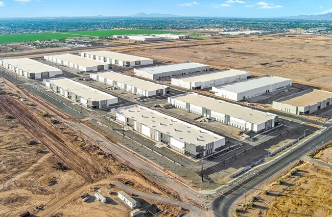


Property Detail
4232 S Sossaman Rd
Phoenix-Mesa-Chandler, AZ
HUB AT 202 MCR 1713-13
304-17-989
MARICOPA
Warehouse
Arizona
2025
8
2025
8.98 AC
422654
Chandler N/Gilbert
136,334 SF
Phoenix
NEARBY LISTINGS FOR SALE OR LEASE
DEMOGRAPHICS near 4232 S Sossaman Rd
1 mile
3 mile
5 mile
2025 Total Population
913
80,893
254,610
2030 Population
1,089
85,013
266,103
Pop Growth 2025-2030
+ 19.28%
+ 5.09%
+ 4.51%
Average Age
34
36
38
2025 Total Households
217
26,506
88,008
HH Growth 2025-2030
+ 20.28%
+ 5.18%
+ 4.65%
Median Household Inc
$39,582
$111,516
$107,772
Avg Household Size
3.10
3.00
2.80
2025 Avg HH Vehicles
2.00
2.00
2.00
Median Home Value
$715,277
$504,119
$501,913
Median Year Built
2011
2004
2003
Nearby Places
Map Layers
Map Styles
 Street
 Aerial
Layers
 Traffic
 Biking
Places
Listings with unknown addresses are not visible on the map
- Restaurants
- Banks
- Shops
- Fitness
- Groceries
PUBLIC TRANSPORTATION
AIRPORT
Phoenix-Mesa Gateway
Drive
Walk
Distance
Phoenix-Mesa Gateway
12 min
6.0 mi
Phoenix Sky Harbor International
Drive
Walk
Distance
Phoenix Sky Harbor International
37 min
26.6 mi
Nearby Properties
Address
Land Use
TOTAL SIZE
Lot Size
Zoning
Address
Land Use
TOTAL SIZE
Lot Size
Zoning
184.86 AC
Address
Land Use
TOTAL SIZE
Lot Size
Zoning
93,214 SF
10.60 AC
PF
Address
Land Use
TOTAL SIZE
Lot Size
Zoning
93.03 AC
Address
Land Use
TOTAL SIZE
Lot Size
Zoning
484,906 SF
199.48 AC
Address
Land Use
TOTAL SIZE
Lot Size
Zoning
1,195,173 SF
71.41 AC
Address
Land Use
TOTAL SIZE
Lot Size
Zoning
1,358,386 SF
611.30 AC
LI
Address
Land Use
TOTAL SIZE
Lot Size
Zoning
862,568 SF
420.15 AC
PS
Address
Land Use
TOTAL SIZE
Lot Size
Zoning
16.38 AC
Address
Land Use
TOTAL SIZE
Lot Size
Zoning
12.66 AC
Address
Land Use
TOTAL SIZE
Lot Size
Zoning
604,432 SF
56.74 AC
PF
Address
Land Use
TOTAL SIZE
Lot Size
Zoning
403,171 SF
34.53 AC
PF
Address
Land Use
TOTAL SIZE
Lot Size
Zoning
580,492 SF
41.81 AC
R3
Address
Land Use
TOTAL SIZE
Lot Size
Zoning
615,202 SF
35.88 AC
AG
Address
Land Use
TOTAL SIZE
Lot Size
Zoning
524,905 SF
40.33 AC
Address
Land Use
TOTAL SIZE
Lot Size
Zoning
15.78 AC
Address
Land Use
TOTAL SIZE
Lot Size
Zoning
245,425 SF
205.62 AC
I-1
Address
Land Use
TOTAL SIZE
Lot Size
Zoning
412,581 SF
21.15 AC
MFM
Address
Land Use
TOTAL SIZE
Lot Size
Zoning
18.36 AC
Address
Land Use
TOTAL SIZE
Lot Size
Zoning
4.60 AC
C-C
Address
Land Use
TOTAL SIZE
Lot Size
Zoning
396,754 SF
46.84 AC
PF
Address
Land Use
TOTAL SIZE
Lot Size
Zoning
414,288 SF
28.67 AC
LI
Address
Land Use
TOTAL SIZE
Lot Size
Zoning
12.99 AC
Address
Land Use
TOTAL SIZE
Lot Size
Zoning
238,386 SF
40.25 AC
BP
Address
Land Use
TOTAL SIZE
Lot Size
Zoning
94,701 SF
7.89 AC
LC
Address
Land Use
TOTAL SIZE
Lot Size
Zoning
308,343 SF
13.90 AC
MFM
Address
Land Use
TOTAL SIZE
Lot Size
Zoning
266,467 SF
47.47 AC
PF
Address
Land Use
TOTAL SIZE
Lot Size
Zoning
274,993 SF
16.44 AC
Address
Land Use
TOTAL SIZE
Lot Size
Zoning
14.77 AC
I-1
Address
Land Use
TOTAL SIZE
Lot Size
Zoning
283,393 SF
6 AC
GVC
Address
Land Use
TOTAL SIZE
Lot Size
Zoning
281,929 SF
12.07 AC
The World's #1 Commercial Real Estate Marketplace
Connect with us
© 2026 CoStar Group
The information above has been obtained from sources believed reliable. While we do not doubt its accuracy we have not verified it and make no guarantee, warranty or representation about it. It is your responsibility to independently confirm its accuracy and completeness. Any projections, opinions, assumptions, or estimates used are for example only and do not represent the current or future performance of the property. The value of this transaction to you depends on tax and other factors which should be evaluated by your tax, financial, and legal advisors. You and your advisors should conduct a careful, independent investigation of the property to determine to your satisfaction the suitability of the property for your needs.