Property Record
4233 Egan Dr, Savage, MN 55378
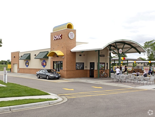


Property Detail
4233 Egan Dr
Minneapolis-St. Paul-Bloomington, MN-WI
RIVER BEND PLAZA LOT 001 BLOCK 001
26-427-001-0
Scott
Commercialnec
Minnesota
B and X Area of moderate flood hazard, usually the area between the limits of the 100-year and 500-year floods.
1
2025
1.02 AC
2025
Burnsville
080207
Minneapolis/St Paul
2,076 SF
NEARBY LISTINGS FOR SALE OR LEASE
DEMOGRAPHICS near 4233 Egan Dr
1 mile
3 mile
5 mile
2024 Total Population
10,033
61,250
149,012
2029 Population
10,161
62,604
152,194
Pop Growth 2024-2029
+ 1.28%
+ 2.21%
+ 2.14%
Average Age
37
39
40
2024 Total Households
3,204
22,452
56,020
HH Growth 2024-2029
+ 1.40%
+ 2.38%
+ 2.23%
Median Household Inc
$104,328
$95,507
$99,483
Avg Household Size
3.00
2.70
2.60
2024 Avg HH Vehicles
2.00
2.00
2.00
Median Home Value
$375,883
$386,766
$391,113
Median Year Built
1989
1990
1986
Nearby Places
Map Layers
Map Styles
 Street
 Aerial
Transit
 Traffic
 Biking
Places
Listings with unknown addresses are not visible on the map
- Restaurants
- Banks
- Shops
- Fitness
- Groceries
PUBLIC TRANSPORTATION
AIRPORT
Minneapolis-St Paul International/Wold-Chamberlain
Drive
Walk
Distance
Minneapolis-St Paul International/Wold-Chamberlain
24 min
16.0 mi
Freight Ports
Port Milwaukee
Drive
Walk
Distance
Port Milwaukee
387 min
348.6 mi
SALE & LEASE HISTORY
LISTING DATE
SALE/LEASE

Aug 05, 2019
For Lease
Nearby Properties
Address
Land Use
TOTAL SIZE
Lot Size
Zoning
Address
Land Use
TOTAL SIZE
Lot Size
Zoning
378,396 SF
20.25 AC
Address
Land Use
TOTAL SIZE
Lot Size
Zoning
339,871 SF
26.64 AC
Address
Land Use
TOTAL SIZE
Lot Size
Zoning
525,323 SF
8.09 AC
Address
Land Use
TOTAL SIZE
Lot Size
Zoning
454,738 SF
106.74 AC
Address
Land Use
TOTAL SIZE
Lot Size
Zoning
184,747 SF
8.44 AC
Address
Land Use
TOTAL SIZE
Lot Size
Zoning
584,692 SF
15.70 AC
Address
Land Use
TOTAL SIZE
Lot Size
Zoning
8.70 AC
Address
Land Use
TOTAL SIZE
Lot Size
Zoning
394,700 SF
13.23 AC
Address
Land Use
TOTAL SIZE
Lot Size
Zoning
419,750 SF
13.83 AC
Address
Land Use
TOTAL SIZE
Lot Size
Zoning
289,168 SF
11.73 AC
Address
Land Use
TOTAL SIZE
Lot Size
Zoning
10.57 AC
Address
Land Use
TOTAL SIZE
Lot Size
Zoning
265,406 SF
26.78 AC
Address
Land Use
TOTAL SIZE
Lot Size
Zoning
276,290 SF
7.44 AC
Address
Land Use
TOTAL SIZE
Lot Size
Zoning
216,267 SF
3.69 AC
Address
Land Use
TOTAL SIZE
Lot Size
Zoning
234,348 SF
11.21 AC
Address
Land Use
TOTAL SIZE
Lot Size
Zoning
190,865 SF
3.67 AC
Address
Land Use
TOTAL SIZE
Lot Size
Zoning
239,047 SF
9.14 AC
Address
Land Use
TOTAL SIZE
Lot Size
Zoning
241,204 SF
14.54 AC
Address
Land Use
TOTAL SIZE
Lot Size
Zoning
106,944 SF
13.21 AC
Address
Land Use
TOTAL SIZE
Lot Size
Zoning
216,700 SF
43.17 AC
Address
Land Use
TOTAL SIZE
Lot Size
Zoning
136,535 SF
4.99 AC
Address
Land Use
TOTAL SIZE
Lot Size
Zoning
324,094 SF
44.01 AC
Address
Land Use
TOTAL SIZE
Lot Size
Zoning
120,090 SF
3.16 AC
Address
Land Use
TOTAL SIZE
Lot Size
Zoning
153,369 SF
4.84 AC
Address
Land Use
TOTAL SIZE
Lot Size
Zoning
276,392 SF
6.55 AC
Address
Land Use
TOTAL SIZE
Lot Size
Zoning
150,867 SF
100.29 AC
Address
Land Use
TOTAL SIZE
Lot Size
Zoning
179,761 SF
7.04 AC
Address
Land Use
TOTAL SIZE
Lot Size
Zoning
245,291 SF
12.64 AC
Address
Land Use
TOTAL SIZE
Lot Size
Zoning
419,750 SF
10.86 AC
Address
Land Use
TOTAL SIZE
Lot Size
Zoning
75,339 SF
3.99 AC
The World's #1 Commercial Real Estate Marketplace
Connect with us
© 2026 CoStar Group
The information above has been obtained from sources believed reliable. While we do not doubt its accuracy we have not verified it and make no guarantee, warranty or representation about it. It is your responsibility to independently confirm its accuracy and completeness. Any projections, opinions, assumptions, or estimates used are for example only and do not represent the current or future performance of the property. The value of this transaction to you depends on tax and other factors which should be evaluated by your tax, financial, and legal advisors. You and your advisors should conduct a careful, independent investigation of the property to determine to your satisfaction the suitability of the property for your needs.