Property Record
4234 Artesia Blvd, Torrance, CA 90504
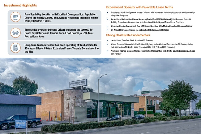


This Property Is For Sale
NEARBY LISTINGS FOR SALE OR LEASE
Property Detail
4234 Artesia Blvd
Los Angeles-Long Beach-Glendale, CA
Mcdonald Tr San Pedro Ro Lot
4085-015-049
MCDONALD TR SAN PEDRO RO LOT COM S 20 FT AND W 412.5 FT FROM NE COR OF LOT 15 TH W 82.5 FT WITH A UNIFORM DEPTH OF 170.5 FT S PART OF LOT 15
Officebuilding
Los Angeles
X
California
06037C1930F
15
2024
0.33 AC
2025
Torrance
650102
Los Angeles
6,705 SF
DEMOGRAPHICS near 4234 Artesia Blvd
1 Mile
3 Mile
5 Mile
2024 Total Population
34,848
279,806
595,765
2029 Population
33,695
272,049
578,567
Pop Growth 2024-2029
(3.31%)
(2.77%)
(2.89%)
Average Age
39
40
40
2024 Total Households
12,253
101,763
212,123
HH Growth 2024-2029
(3.57%)
(2.99%)
(3.05%)
Median Household Inc
$87,027
$95,078
$92,477
Avg Household Size
2.80
2.70
2.70
2024 Avg HH Vehicles
2.00
2.00
2.00
Median Home Value
$773,410
$889,030
$866,236
Median Year Built
1961
1965
1964
Nearby Places
Map Layers
Map Styles
 Street
 Aerial
- Restaurants
- Banks
- Shops
- Fitness
- Groceries
PUBLIC TRANSPORTATION
AIRPORT
Los Angeles International
DRIVE
WALK
Distance
Los Angeles International
14 min
8.7 mi
Long Beach (Daugherty Field)
DRIVE
WALK
Distance
Long Beach (Daugherty Field)
17 min
12.6 mi
Bob Hope
DRIVE
WALK
Distance
Bob Hope
43 min
32.3 mi
Freight Ports
Port of Los Angeles
DRIVE
WALK
Distance
Port of Los Angeles
24 min
15.8 mi
Nearby Properties
Address
Land Use
TOTAL SIZE
Lot Size
Zoning
Address
Land Use
TOTAL SIZE
Lot Size
Zoning
584,746 SF
20.38 AC
MNIP
Address
Land Use
TOTAL SIZE
Lot Size
Zoning
997,143 SF
98.35 AC
TOMI-BP
Address
Land Use
TOTAL SIZE
Lot Size
Zoning
205,797 SF
4.10 AC
HBR3*
Address
Land Use
TOTAL SIZE
Lot Size
Zoning
10,152 SF
140.14 AC
TOMI-HVY
Address
Land Use
TOTAL SIZE
Lot Size
Zoning
421,934 SF
8.24 AC
ESCM
Address
Land Use
TOTAL SIZE
Lot Size
Zoning
267,131 SF
12.10 AC
TOHHM
Address
Land Use
TOTAL SIZE
Lot Size
Zoning
718,086 SF
41.24 AC
RBI-1A
Address
Land Use
TOTAL SIZE
Lot Size
Zoning
848,217 SF
36.09 AC
RBI-1A
Address
Land Use
TOTAL SIZE
Lot Size
Zoning
321,011 SF
15.06 AC
TOMI-LT
Address
Land Use
TOTAL SIZE
Lot Size
Zoning
297,420 SF
6.65 AC
TOHC-CTR
Address
Land Use
TOTAL SIZE
Lot Size
Zoning
173,186 SF
2.07 AC
HBR3*
Address
Land Use
TOTAL SIZE
Lot Size
Zoning
604,106 SF
42.72 AC
TOMI-HVY
Address
Land Use
TOTAL SIZE
Lot Size
Zoning
1,504,661 SF
RBCR
Address
Land Use
TOTAL SIZE
Lot Size
Zoning
3,585,714 SF
67.35 AC
LAM3
Address
Land Use
TOTAL SIZE
Lot Size
Zoning
202,924 SF
6.15 AC
TOHC-CTR
Address
Land Use
TOTAL SIZE
Lot Size
Zoning
184,300 SF
8.14 AC
LAM3
Address
Land Use
TOTAL SIZE
Lot Size
Zoning
257,723 SF
4.06 AC
TOCC-GEN
Address
Land Use
TOTAL SIZE
Lot Size
Zoning
833,484 SF
6.62 AC
ESM2YY
Address
Land Use
TOTAL SIZE
Lot Size
Zoning
405,352 SF
7.70 AC
TOHC-CTR
Address
Land Use
TOTAL SIZE
Lot Size
Zoning
239,992 SF
4.72 AC
RBI-1B
Address
Land Use
TOTAL SIZE
Lot Size
Zoning
103,228 SF
1.19 AC
TORR-HI
Address
Land Use
TOTAL SIZE
Lot Size
Zoning
502,236 SF
11.58 AC
TOMI-LT
Address
Land Use
TOTAL SIZE
Lot Size
Zoning
282,280 SF
Address
Land Use
TOTAL SIZE
Lot Size
Zoning
176,514 SF
3.74 AC
TORR-MH
Address
Land Use
TOTAL SIZE
Lot Size
Zoning
92,374 SF
2.59 AC
ESCM*
The World's #1 Commercial Real Estate Marketplace
Connect with us
© 2025 CoStar Group
The information above has been obtained from sources believed reliable. While we do not doubt its accuracy we have not verified it and make no guarantee, warranty or representation about it. It is your responsibility to independently confirm its accuracy and completeness. Any projections, opinions, assumptions, or estimates used are for example only and do not represent the current or future performance of the property. The value of this transaction to you depends on tax and other factors which should be evaluated by your tax, financial, and legal advisors. You and your advisors should conduct a careful, independent investigation of the property to determine to your satisfaction the suitability of the property for your needs.