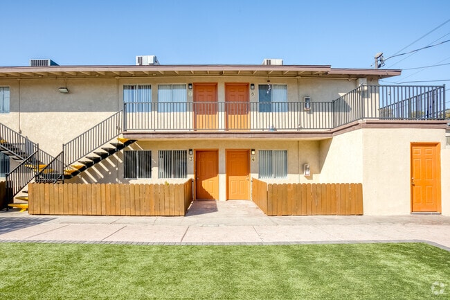
Property Record
4237 Silver Dollar Ave, Las Vegas, NV 89102

NEARBY LISTINGS FOR SALE OR LEASE
Property Detail
4237 Silver Dollar Ave
Las Vegas-Henderson-North Las Vegas, NV
Fabulous Forty
162-07-623-040
FABULOUS FORTY PLAT BOOK 8 PAGE 2 LOT 1 BLOCK 3 & LOTS 2-11
Apartment
Clark
X
Nevada
32003C2165D
1
2026
2.03 AC
2026
Richfield
002204
Las Vegas
57,190 SF
DEMOGRAPHICS near 4237 Silver Dollar Ave
1 Mile
3 Mile
5 Mile
2024 Total Population
33,748
159,274
465,342
2029 Population
36,818
172,311
500,806
Pop Growth 2024-2029
+ 9.10%
+ 8.19%
+ 7.62%
Average Age
37
40
39
2024 Total Households
12,889
67,549
188,071
HH Growth 2024-2029
+ 9.02%
+ 8.37%
+ 7.67%
Median Household Inc
$37,224
$43,425
$43,823
Avg Household Size
2.50
2.30
2.40
2024 Avg HH Vehicles
1.00
1.00
1.00
Median Home Value
$268,780
$311,008
$297,363
Median Year Built
1980
1983
1984
Nearby Places
Map Layers
Map Styles
 Street
 Aerial
- Restaurants
- Banks
- Shops
- Fitness
- Groceries
PUBLIC TRANSPORTATION
AIRPORT
Harry Reid International
DRIVE
WALK
Distance
Harry Reid International
13 min
6.5 mi
Boulder City Municipal
DRIVE
WALK
Distance
Boulder City Municipal
40 min
28.0 mi
Freight Ports
Port of Long Beach
DRIVE
WALK
Distance
Port of Long Beach
315 min
281.7 mi
Nearby Properties
Address
Land Use
TOTAL SIZE
Lot Size
Zoning
Address
Land Use
TOTAL SIZE
Lot Size
Zoning
3,693,440 SF
43.59 AC
Address
Land Use
TOTAL SIZE
Lot Size
Zoning
3,391,505 SF
68.52 AC
Address
Land Use
TOTAL SIZE
Lot Size
Zoning
3,391,505 SF
68.55 AC
Address
Land Use
TOTAL SIZE
Lot Size
Zoning
1,546,466 SF
61.43 AC
H1
Address
Land Use
TOTAL SIZE
Lot Size
Zoning
1,172,527 SF
19.67 AC
H1
Address
Land Use
TOTAL SIZE
Lot Size
Zoning
2,207,746 SF
74.17 AC
Address
Land Use
TOTAL SIZE
Lot Size
Zoning
1,044,724 SF
56.56 AC
Address
Land Use
TOTAL SIZE
Lot Size
Zoning
820,224 SF
59.80 AC
H1
Address
Land Use
TOTAL SIZE
Lot Size
Zoning
8,805 SF
45.63 AC
Address
Land Use
TOTAL SIZE
Lot Size
Zoning
1,447,338 SF
65.25 AC
H1
Address
Land Use
TOTAL SIZE
Lot Size
Zoning
2,414,853 SF
16.59 AC
H1
Address
Land Use
TOTAL SIZE
Lot Size
Zoning
74,148 SF
18.51 AC
Address
Land Use
TOTAL SIZE
Lot Size
Zoning
763,204 SF
10.47 AC
H1
Address
Land Use
TOTAL SIZE
Lot Size
Zoning
225,512 SF
50.14 AC
Address
Land Use
TOTAL SIZE
Lot Size
Zoning
112,160 SF
20.60 AC
Address
Land Use
TOTAL SIZE
Lot Size
Zoning
742,547 SF
19.87 AC
H1
Address
Land Use
TOTAL SIZE
Lot Size
Zoning
248,689 SF
19.45 AC
H1
Address
Land Use
TOTAL SIZE
Lot Size
Zoning
318,755 SF
29.92 AC
Address
Land Use
TOTAL SIZE
Lot Size
Zoning
171,303 SF
17.87 AC
H1
Address
Land Use
TOTAL SIZE
Lot Size
Zoning
1,911,901 SF
1.24 AC
Address
Land Use
TOTAL SIZE
Lot Size
Zoning
299,144 SF
19.37 AC
Address
Land Use
TOTAL SIZE
Lot Size
Zoning
777,838 SF
36.14 AC
H1
Address
Land Use
TOTAL SIZE
Lot Size
Zoning
3,200 SF
16.74 AC
Address
Land Use
TOTAL SIZE
Lot Size
Zoning
1,744,547 SF
8.25 AC
Address
Land Use
TOTAL SIZE
Lot Size
Zoning
659,669 SF
24.79 AC
H1
Address
Land Use
TOTAL SIZE
Lot Size
Zoning
873,377 SF
28.08 AC
Address
Land Use
TOTAL SIZE
Lot Size
Zoning
524,471 SF
59.01 AC
Address
Land Use
TOTAL SIZE
Lot Size
Zoning
1,345,377 SF
88.53 AC
H1
Address
Land Use
TOTAL SIZE
Lot Size
Zoning
1,069,498 SF
28.36 AC
H1
Address
Land Use
TOTAL SIZE
Lot Size
Zoning
566,218 SF
12.98 AC
The World's #1 Commercial Real Estate Marketplace
Connect with us
© 2026 CoStar Group
The information above has been obtained from sources believed reliable. While we do not doubt its accuracy we have not verified it and make no guarantee, warranty or representation about it. It is your responsibility to independently confirm its accuracy and completeness. Any projections, opinions, assumptions, or estimates used are for example only and do not represent the current or future performance of the property. The value of this transaction to you depends on tax and other factors which should be evaluated by your tax, financial, and legal advisors. You and your advisors should conduct a careful, independent investigation of the property to determine to your satisfaction the suitability of the property for your needs.