Property Record
4211 Flat Shoals Pky, Decatur, GA 30034
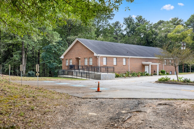
This Property Is For Sale
NEARBY LISTINGS FOR SALE OR LEASE
Property Detail
4211 Flat Shoals Pky
15-070-03-042
Gods True Worshippers Church
Officebuilding
DeKalb
X
Georgia
13063C0045F
42
2025
3.29 AC
2025
I-20 East/Conyers
023439
Atlanta
10,800 SF
Atlanta-Sandy Springs-Roswell, GA
DEMOGRAPHICS near 4211 Flat Shoals Pky
1 Mile
3 Mile
5 Mile
2024 Total Population
9,764
69,795
174,160
2029 Population
9,863
70,809
177,317
Pop Growth 2024-2029
+ 1.01%
+ 1.45%
+ 1.81%
Average Age
37
41
40
2024 Total Households
3,626
25,650
65,575
HH Growth 2024-2029
+ 0.97%
+ 1.47%
+ 1.79%
Median Household Inc
$70,362
$67,118
$70,317
Avg Household Size
2.60
2.60
2.60
2024 Avg HH Vehicles
2.00
2.00
2.00
Median Home Value
$255,449
$266,356
$280,663
Median Year Built
1990
1982
1982
Nearby Places
- Restaurants
- Banks
- Shops
- Fitness
- Groceries
PUBLIC TRANSPORTATION
AIRPORT
Hartsfield - Jackson Atlanta International
DRIVE
WALK
Distance
Hartsfield - Jackson Atlanta International
21 min
12.7 mi
Freight Ports
Georgia Ports - Savannah
DRIVE
WALK
Distance
Georgia Ports - Savannah
274 min
244.6 mi
Nearby Properties
Address
Land Use
TOTAL SIZE
Lot Size
Zoning
Address
Land Use
TOTAL SIZE
Lot Size
Zoning
284,650 SF
21.75 AC
R100
Address
Land Use
TOTAL SIZE
Lot Size
Zoning
522,850 SF
41.34 AC
RM75
Address
Land Use
TOTAL SIZE
Lot Size
Zoning
278,121 SF
20 AC
RM85
Address
Land Use
TOTAL SIZE
Lot Size
Zoning
72,870 SF
12.34 AC
C2
Address
Land Use
TOTAL SIZE
Lot Size
Zoning
245,053 SF
22.77 AC
RM85
Address
Land Use
TOTAL SIZE
Lot Size
Zoning
253,740 SF
13.33 AC
RM75
Address
Land Use
TOTAL SIZE
Lot Size
Zoning
13,114 SF
17.54 AC
RM100
Address
Land Use
TOTAL SIZE
Lot Size
Zoning
235,787 SF
15.43 AC
RM100
Address
Land Use
TOTAL SIZE
Lot Size
Zoning
554,853 SF
42.64 AC
RM75
Address
Land Use
TOTAL SIZE
Lot Size
Zoning
174,027 SF
35.37 AC
R100
Address
Land Use
TOTAL SIZE
Lot Size
Zoning
419,434 SF
21.59 AC
RM85
Address
Land Use
TOTAL SIZE
Lot Size
Zoning
300,697 SF
21.18 AC
RM85
Address
Land Use
TOTAL SIZE
Lot Size
Zoning
86,140 SF
61.60 AC
R100
Address
Land Use
TOTAL SIZE
Lot Size
Zoning
132,604 SF
19.12 AC
RM100
Address
Land Use
TOTAL SIZE
Lot Size
Zoning
367,452 SF
30.89 AC
RM100
Address
Land Use
TOTAL SIZE
Lot Size
Zoning
217,904 SF
14.84 AC
Address
Land Use
TOTAL SIZE
Lot Size
Zoning
259,678 SF
14.20 AC
RM85
Address
Land Use
TOTAL SIZE
Lot Size
Zoning
278,272 SF
21 AC
RM100
Address
Land Use
TOTAL SIZE
Lot Size
Zoning
320,450 SF
38.85 AC
M
Address
Land Use
TOTAL SIZE
Lot Size
Zoning
259,845 SF
17.12 AC
RM85
Address
Land Use
TOTAL SIZE
Lot Size
Zoning
134,156 SF
12.41 AC
RM100
Address
Land Use
TOTAL SIZE
Lot Size
Zoning
124,603 SF
10.60 AC
M
Address
Land Use
TOTAL SIZE
Lot Size
Zoning
140,779 SF
30.63 AC
X
Address
Land Use
TOTAL SIZE
Lot Size
Zoning
151,804 SF
10.87 AC
RM100
Address
Land Use
TOTAL SIZE
Lot Size
Zoning
70,822 SF
11.90 AC
RM75
Address
Land Use
TOTAL SIZE
Lot Size
Zoning
105,100 SF
11.43 AC
C1: LOCAL
Address
Land Use
TOTAL SIZE
Lot Size
Zoning
157,567 SF
16.89 AC
M: INDUSTR
Address
Land Use
TOTAL SIZE
Lot Size
Zoning
93,259 SF
6.32 AC
M
Address
Land Use
TOTAL SIZE
Lot Size
Zoning
98,423 SF
7.45 AC
OD: OF DIS
Address
Land Use
TOTAL SIZE
Lot Size
Zoning
351,345 SF
51.89 AC
C1: LOCAL
The World's #1 Commercial Real Estate Marketplace
Connect with us
© 2025 CoStar Group
The information above has been obtained from sources believed reliable. While we do not doubt its accuracy we have not verified it and make no guarantee, warranty or representation about it. It is your responsibility to independently confirm its accuracy and completeness. Any projections, opinions, assumptions, or estimates used are for example only and do not represent the current or future performance of the property. The value of this transaction to you depends on tax and other factors which should be evaluated by your tax, financial, and legal advisors. You and your advisors should conduct a careful, independent investigation of the property to determine to your satisfaction the suitability of the property for your needs.