Property Record
424 Highway 101, Landrum, SC 29356

Save to a Folder
{{folder.Name}}
{{folder.ListingIds.length}} Properties
{{folder.ListingIds.length}} Property
Create a New Folder
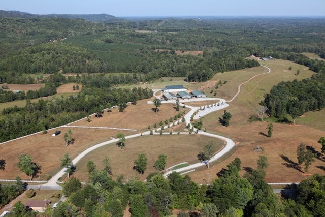
Property Detail
424 Highway 101
Greenville-Anderson-Greer, SC
A B
0644.02-01-002.02
Greenville
Privateschool
South Carolina
UNZONED
002.02
B and X Area of moderate flood hazard, usually the area between the limits of the 100-year and 500-year floods.
22.24 AC
0
Travelers Rest
2025
Greenville/Spartanburg
002404
NEARBY LISTINGS FOR SALE OR LEASE
-
-
View all Landrum listings for sale on LoopNet.com
DEMOGRAPHICS near 424 Highway 101
1 mile
3 mile
5 mile
2025 Total Population
258
4,287
9,934
2030 Population
280
4,680
10,850
Pop Growth 2025-2030
+ 8.53%
+ 9.17%
+ 9.22%
Average Age
45
43
43
2025 Total Households
104
1,514
3,552
HH Growth 2025-2030
+ 9.62%
+ 9.78%
+ 9.77%
Median Household Inc
$92,968
$101,609
$93,352
Avg Household Size
2.40
2.40
2.40
2025 Avg HH Vehicles
2.00
2.00
2.00
Median Home Value
$602,941
$521,329
$444,266
Median Year Built
1988
1997
1996
Nearby Places
Map Layers
Map Styles
 Street
 Aerial
Layers
 Traffic
 Biking
Places
Listings with unknown addresses are not visible on the map
- Restaurants
- Banks
- Shops
- Fitness
- Groceries
PUBLIC TRANSPORTATION
AIRPORT
Greenville Spartanburg International
Drive
Walk
Distance
Greenville Spartanburg International
31 min
17.2 mi
Asheville Regional
Drive
Walk
Distance
Asheville Regional
51 min
38.2 mi
Nearby Properties
Address
Land Use
TOTAL SIZE
Lot Size
Zoning
Address
Land Use
TOTAL SIZE
Lot Size
Zoning
1,650 SF
16.98 AC
UNZONED
Address
Land Use
TOTAL SIZE
Lot Size
Zoning
57.90 AC
UNZONED
Address
Land Use
TOTAL SIZE
Lot Size
Zoning
27.02 AC
UNZONED
Address
Land Use
TOTAL SIZE
Lot Size
Zoning
40.59 AC
UNZONED
Address
Land Use
TOTAL SIZE
Lot Size
Zoning
19.30 AC
UNZONED
Address
Land Use
TOTAL SIZE
Lot Size
Zoning
1,454 SF
11.84 AC
UNZONED
Address
Land Use
TOTAL SIZE
Lot Size
Zoning
16.22 AC
UNZONED
Address
Land Use
TOTAL SIZE
Lot Size
Zoning
2 AC
UNZONED
Address
Land Use
TOTAL SIZE
Lot Size
Zoning
12 AC
UNZONED
Address
Land Use
TOTAL SIZE
Lot Size
Zoning
11.78 AC
Address
Land Use
TOTAL SIZE
Lot Size
Zoning
5.30 AC
UNZONED
Address
Land Use
TOTAL SIZE
Lot Size
Zoning
7.11 AC
UNZONED
Address
Land Use
TOTAL SIZE
Lot Size
Zoning
2.28 AC
Address
Land Use
TOTAL SIZE
Lot Size
Zoning
5.80 AC
UNZONED
Address
Land Use
TOTAL SIZE
Lot Size
Zoning
5.20 AC
UNZONED
Address
Land Use
TOTAL SIZE
Lot Size
Zoning
0.60 AC
UNZONED
Address
Land Use
TOTAL SIZE
Lot Size
Zoning
0.80 AC
UNZONED
Address
Land Use
TOTAL SIZE
Lot Size
Zoning
5.98 AC
UNZONED
Address
Land Use
TOTAL SIZE
Lot Size
Zoning
1,590 SF
4 AC
UNZONED
Address
Land Use
TOTAL SIZE
Lot Size
Zoning
1,351 SF
3.88 AC
UNZONED
Address
Land Use
TOTAL SIZE
Lot Size
Zoning
0.40 AC
UNZONED
Address
Land Use
TOTAL SIZE
Lot Size
Zoning
0.15 AC
UNZONED
Address
Land Use
TOTAL SIZE
Lot Size
Zoning
Address
Land Use
TOTAL SIZE
Lot Size
Zoning
3.14 AC
UNZONED
Address
Land Use
TOTAL SIZE
Lot Size
Zoning
0.97 AC
UNZONED
Address
Land Use
TOTAL SIZE
Lot Size
Zoning
2.96 AC
UNZONED
Address
Land Use
TOTAL SIZE
Lot Size
Zoning
2.93 AC
UNZONED
Address
Land Use
TOTAL SIZE
Lot Size
Zoning
2.75 AC
UNZONED
Address
Land Use
TOTAL SIZE
Lot Size
Zoning
2,576 SF
30.99 AC
UNZONED
The World's #1 Commercial Real Estate Marketplace
Connect with us
© 2026 CoStar Group
The information above has been obtained from sources believed reliable. While we do not doubt its accuracy we have not verified it and make no guarantee, warranty or representation about it. It is your responsibility to independently confirm its accuracy and completeness. Any projections, opinions, assumptions, or estimates used are for example only and do not represent the current or future performance of the property. The value of this transaction to you depends on tax and other factors which should be evaluated by your tax, financial, and legal advisors. You and your advisors should conduct a careful, independent investigation of the property to determine to your satisfaction the suitability of the property for your needs.