Property Record
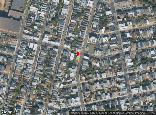
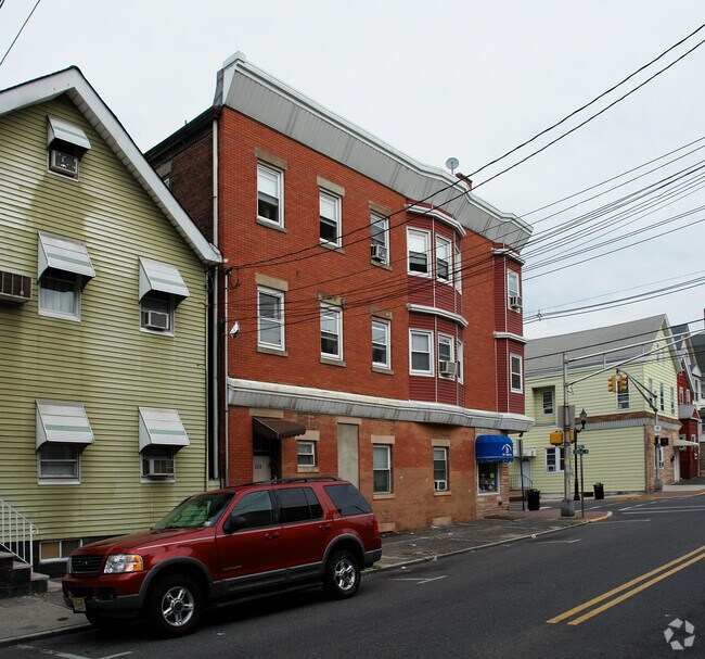
424 N 3Rd St, East Newark, NJ 07029

NEARBY LISTINGS FOR SALE OR LEASE
Property Detail
424 N 3Rd St
02-00005-0000-00023
Hudson
Commercialnec
New Jersey
X
23
34013C0156F
0.03 AC
2024
Meadowlands
2025
Northern New Jersey
013400
New York-Jersey City-White Plains, NY-NJ
DEMOGRAPHICS near 424 N 3Rd St
1 mile
3 mile
5 mile
2024 Total Population
50,569
326,637
754,110
2029 Population
48,309
315,133
728,923
Pop Growth 2024-2029
(4.47%)
(3.52%)
(3.34%)
Average Age
37
37
38
2024 Total Households
19,328
119,097
277,890
HH Growth 2024-2029
(4.16%)
(3.56%)
(3.46%)
Median Household Inc
$65,122
$49,135
$57,000
Avg Household Size
2.50
2.60
2.60
2024 Avg HH Vehicles
1.00
1.00
1.00
Median Home Value
$380,036
$340,472
$350,983
Median Year Built
1970
1966
1958
Nearby Places
Map Layers
Map Styles
 Street
 Aerial
Transit
 Traffic
 Biking
Places
Listings with unknown addresses are not visible on the map
- Restaurants
- Banks
- Shops
- Fitness
- Groceries
PUBLIC TRANSPORTATION
TRANSIT/SUBWAY
Newark-Broad Street (Broad Street Station - Newark Penn Station - Newark Light Rail (Newark Light Rail))
Drive
Walk
Distance
Newark-Broad Street (Broad Street Station - Newark Penn Station - Newark Light Rail (Newark Light Rail))
4 min
16 min
0.8 mi
Newark Broad Street (Montclair-Boonton Line - NJ Transit Commuter Rail (NJ Transit), Morris & Essex Gladstone Branch - NJ Transit Commuter Rail (NJ Transit), Morris & Essex Morristown Line - NJ Transit Commuter Rail (NJ Transit))
Drive
Walk
Distance
Newark Broad Street (Montclair-Boonton Line - NJ Transit Commuter Rail (NJ Transit), Morris & Essex Gladstone Branch - NJ Transit Commuter Rail (NJ Transit), Morris & Essex Morristown Line - NJ Transit Commuter Rail (NJ Transit))
4 min
16 min
0.8 mi
Atlantic Street (Broad Street Station - Newark Penn Station - Newark Light Rail (Newark Light Rail))
Drive
Walk
Distance
Atlantic Street (Broad Street Station - Newark Penn Station - Newark Light Rail (Newark Light Rail))
3 min
16 min
0.8 mi
Washington Park (Broad Street Station - Newark Penn Station - Newark Light Rail (Newark Light Rail))
Drive
Walk
Distance
Washington Park (Broad Street Station - Newark Penn Station - Newark Light Rail (Newark Light Rail))
3 min
18 min
0.9 mi
Riverfront Stadium (Broad Street Station - Newark Penn Station - Newark Light Rail (Newark Light Rail))
Drive
Walk
Distance
Riverfront Stadium (Broad Street Station - Newark Penn Station - Newark Light Rail (Newark Light Rail))
3 min
18 min
0.9 mi
COMMUTER RAIL
Harrison (Newark Penn Station-World Trade Center - Port Authority Trans-Hudson (PATH))
Drive
Walk
Distance
Harrison (Newark Penn Station-World Trade Center - Port Authority Trans-Hudson (PATH))
2 min
17 min
0.8 mi
Newark Broad Street (Montclair-Boonton Line - NJ Transit Commuter Rail (NJ Transit), Morris & Essex Gladstone Branch - NJ Transit Commuter Rail (NJ Transit), Morris & Essex Morristown Line - NJ Transit Commuter Rail (NJ Transit))
Drive
Walk
Distance
Newark Broad Street (Montclair-Boonton Line - NJ Transit Commuter Rail (NJ Transit), Morris & Essex Gladstone Branch - NJ Transit Commuter Rail (NJ Transit), Morris & Essex Morristown Line - NJ Transit Commuter Rail (NJ Transit))
4 min
17 min
0.9 mi
AIRPORT
Newark Liberty International
Drive
Walk
Distance
Newark Liberty International
12 min
5.4 mi
LaGuardia
Drive
Walk
Distance
LaGuardia
42 min
19.3 mi
John F Kennedy International
Drive
Walk
Distance
John F Kennedy International
53 min
27.4 mi
Freight Ports
Maher Terminal
Drive
Walk
Distance
Maher Terminal
16 min
7.0 mi
Nearby Properties
Address
Land Use
TOTAL SIZE
Lot Size
Zoning
Address
Land Use
TOTAL SIZE
Lot Size
Zoning
0.57 AC
Address
Land Use
TOTAL SIZE
Lot Size
Zoning
0.45 AC
Address
Land Use
TOTAL SIZE
Lot Size
Zoning
31.86 AC
Address
Land Use
TOTAL SIZE
Lot Size
Zoning
25.69 AC
Address
Land Use
TOTAL SIZE
Lot Size
Zoning
Address
Land Use
TOTAL SIZE
Lot Size
Zoning
877 SF
7.25 AC
Address
Land Use
TOTAL SIZE
Lot Size
Zoning
4.51 AC
Address
Land Use
TOTAL SIZE
Lot Size
Zoning
683 SF
9.59 AC
Address
Land Use
TOTAL SIZE
Lot Size
Zoning
2,500 SF
43.35 AC
Address
Land Use
TOTAL SIZE
Lot Size
Zoning
2.01 AC
Address
Land Use
TOTAL SIZE
Lot Size
Zoning
3.42 AC
Address
Land Use
TOTAL SIZE
Lot Size
Zoning
320 SF
1.25 AC
Address
Land Use
TOTAL SIZE
Lot Size
Zoning
710 SF
39.32 AC
Address
Land Use
TOTAL SIZE
Lot Size
Zoning
9.77 AC
Address
Land Use
TOTAL SIZE
Lot Size
Zoning
877 SF
0.91 AC
Address
Land Use
TOTAL SIZE
Lot Size
Zoning
1.64 AC
Address
Land Use
TOTAL SIZE
Lot Size
Zoning
Address
Land Use
TOTAL SIZE
Lot Size
Zoning
1.63 AC
Address
Land Use
TOTAL SIZE
Lot Size
Zoning
17.97 AC
Address
Land Use
TOTAL SIZE
Lot Size
Zoning
Address
Land Use
TOTAL SIZE
Lot Size
Zoning
2.79 AC
Address
Land Use
TOTAL SIZE
Lot Size
Zoning
4.82 AC
Address
Land Use
TOTAL SIZE
Lot Size
Zoning
0.13 AC
Address
Land Use
TOTAL SIZE
Lot Size
Zoning
1,264 SF
3.20 AC
Address
Land Use
TOTAL SIZE
Lot Size
Zoning
Address
Land Use
TOTAL SIZE
Lot Size
Zoning
0.06 AC
Address
Land Use
TOTAL SIZE
Lot Size
Zoning
0.09 AC
Address
Land Use
TOTAL SIZE
Lot Size
Zoning
877 SF
1.95 AC
Address
Land Use
TOTAL SIZE
Lot Size
Zoning
877 SF
1.35 AC
Address
Land Use
TOTAL SIZE
Lot Size
Zoning
683 SF
0.79 AC
The World's #1 Commercial Real Estate Marketplace
Connect with us
© 2026 CoStar Group
The information above has been obtained from sources believed reliable. While we do not doubt its accuracy we have not verified it and make no guarantee, warranty or representation about it. It is your responsibility to independently confirm its accuracy and completeness. Any projections, opinions, assumptions, or estimates used are for example only and do not represent the current or future performance of the property. The value of this transaction to you depends on tax and other factors which should be evaluated by your tax, financial, and legal advisors. You and your advisors should conduct a careful, independent investigation of the property to determine to your satisfaction the suitability of the property for your needs.