Property Record
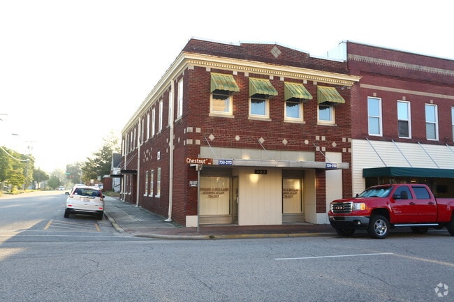
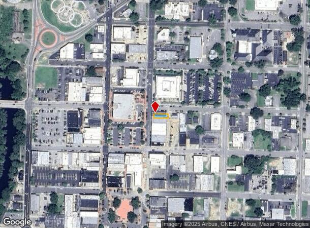
424 N Chestnut St, Lumberton, NC 28358
Current Lease Availabilities
NEARBY LISTINGS FOR SALE OR LEASE
Property Detail
424 N Chestnut St
3233-02-013
Mcintyre Stephen Sd
Officebuilding
LT MCINTYRE STEPHEN SD OF FICE UP & DOWN RENTED
X
Robeson
3710939100K
North Carolina
2025
0.05 AC
2025
North Carolina Southeast Area
961000
Other Market Areas
4,860 SF
Lumberton, NC
DEMOGRAPHICS near 424 N Chestnut St
1 mile
3 mile
5 mile
2024 Total Population
5,911
23,100
33,658
2029 Population
6,031
23,540
34,202
Pop Growth 2024-2029
+ 2.03%
+ 1.90%
+ 1.62%
Average Age
40
38
39
2024 Total Households
2,398
8,901
12,849
HH Growth 2024-2029
+ 1.92%
+ 1.93%
+ 1.63%
Median Household Inc
$33,333
$36,759
$40,771
Avg Household Size
2.30
2.40
2.40
2024 Avg HH Vehicles
1.00
2.00
2.00
Median Home Value
$90,444
$105,163
$109,882
Median Year Built
1960
1976
1981
Nearby Places
Map Layers
Map Styles
 Street
 Aerial
Transit
 Traffic
 Biking
Places
Listings with unknown addresses are not visible on the map
- Restaurants
- Banks
- Shops
- Fitness
- Groceries
PUBLIC TRANSPORTATION
AIRPORT
Fayetteville Regional/Grannis Field
Drive
Walk
Distance
Fayetteville Regional/Grannis Field
38 min
29.1 mi
Nearby Properties
Address
Land Use
TOTAL SIZE
Lot Size
Zoning
Address
Land Use
TOTAL SIZE
Lot Size
Zoning
59,810 SF
7.69 AC
R7
Address
Land Use
TOTAL SIZE
Lot Size
Zoning
116,616 SF
10.18 AC
B6
Address
Land Use
TOTAL SIZE
Lot Size
Zoning
82,115 SF
39.22 AC
R15
Address
Land Use
TOTAL SIZE
Lot Size
Zoning
24,173 SF
44.32 AC
B3
Address
Land Use
TOTAL SIZE
Lot Size
Zoning
134,160 SF
0.26 AC
B6
Address
Land Use
TOTAL SIZE
Lot Size
Zoning
128,531 SF
22.20 AC
B4
Address
Land Use
TOTAL SIZE
Lot Size
Zoning
418,000 SF
31.52 AC
M2
Address
Land Use
TOTAL SIZE
Lot Size
Zoning
120,000 SF
17.10 AC
M2
Address
Land Use
TOTAL SIZE
Lot Size
Zoning
36,329 SF
16.87 AC
R6
Address
Land Use
TOTAL SIZE
Lot Size
Zoning
297,300 SF
128.80 AC
M2
Address
Land Use
TOTAL SIZE
Lot Size
Zoning
24,984 SF
41.13 AC
R11
Address
Land Use
TOTAL SIZE
Lot Size
Zoning
90,800 SF
36.65 AC
R20
Address
Land Use
TOTAL SIZE
Lot Size
Zoning
67,728 SF
1.50 AC
B1
Address
Land Use
TOTAL SIZE
Lot Size
Zoning
69,765 SF
9.51 AC
B4
Address
Land Use
TOTAL SIZE
Lot Size
Zoning
2,187 SF
18.75 AC
R3
Address
Land Use
TOTAL SIZE
Lot Size
Zoning
23,442 SF
7.22 AC
R6
Address
Land Use
TOTAL SIZE
Lot Size
Zoning
33,546 SF
4.97 AC
B4
Address
Land Use
TOTAL SIZE
Lot Size
Zoning
4,048 SF
12.73 AC
R3
Address
Land Use
TOTAL SIZE
Lot Size
Zoning
88,710 SF
1.11 AC
B1
Address
Land Use
TOTAL SIZE
Lot Size
Zoning
95,143 SF
7.55 AC
B4
Address
Land Use
TOTAL SIZE
Lot Size
Zoning
51,003 SF
8.49 AC
B3
Address
Land Use
TOTAL SIZE
Lot Size
Zoning
62,404 SF
12.88 AC
Address
Land Use
TOTAL SIZE
Lot Size
Zoning
59,635 SF
10.24 AC
R11
Address
Land Use
TOTAL SIZE
Lot Size
Zoning
75,704 SF
7.60 AC
R3
Address
Land Use
TOTAL SIZE
Lot Size
Zoning
75,000 SF
13.84 AC
B4
Address
Land Use
TOTAL SIZE
Lot Size
Zoning
5,784 SF
903.32 AC
RA
Address
Land Use
TOTAL SIZE
Lot Size
Zoning
24,880 SF
19.30 AC
R20
Address
Land Use
TOTAL SIZE
Lot Size
Zoning
149,800 SF
66.53 AC
M2
Address
Land Use
TOTAL SIZE
Lot Size
Zoning
1,894 SF
11.48 AC
R3
Address
Land Use
TOTAL SIZE
Lot Size
Zoning
71,260 SF
7.69 AC
B4
The World's #1 Commercial Real Estate Marketplace
Connect with us
© 2026 CoStar Group
The information above has been obtained from sources believed reliable. While we do not doubt its accuracy we have not verified it and make no guarantee, warranty or representation about it. It is your responsibility to independently confirm its accuracy and completeness. Any projections, opinions, assumptions, or estimates used are for example only and do not represent the current or future performance of the property. The value of this transaction to you depends on tax and other factors which should be evaluated by your tax, financial, and legal advisors. You and your advisors should conduct a careful, independent investigation of the property to determine to your satisfaction the suitability of the property for your needs.