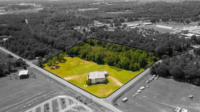
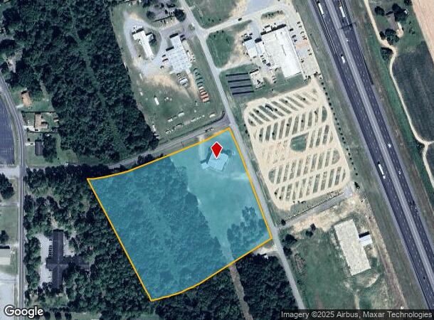
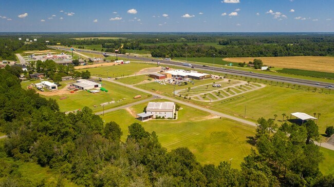
Property Record
424 Sylvia Dr, Ashburn, GA 31714
NEARBY LISTINGS FOR SALE OR LEASE
-
-
View all Ashburn listings for sale on LoopNet.com
Property Detail
424 Sylvia Dr
026A-025
LD2 LL131 9.33AC
Religious
Turner
X
Georgia
13287C0135A
9.33 AC
0
Georgia South Area
2024
Other Market Areas
970202
Tifton, GA
DEMOGRAPHICS near 424 Sylvia Dr
1 Mile
3 Mile
5 Mile
2024 Total Population
1,651
6,019
6,746
2029 Population
1,622
5,890
6,596
Pop Growth 2024-2029
(1.76%)
(2.14%)
(2.22%)
Average Age
43
40
40
2024 Total Households
722
2,306
2,596
HH Growth 2024-2029
(1.80%)
(2.21%)
(2.27%)
Median Household Inc
$39,884
$33,417
$34,064
Avg Household Size
2.30
2.40
2.40
2024 Avg HH Vehicles
2.00
2.00
2.00
Median Home Value
$89,486
$82,333
$85,178
Median Year Built
1973
1972
1973
Nearby Places
Map Layers
Map Styles
 Street
 Aerial
- Restaurants
- Banks
- Shops
- Fitness
- Groceries
PUBLIC TRANSPORTATION
AIRPORT
Southwest Georgia Regional
DRIVE
WALK
Distance
Southwest Georgia Regional
66 min
42.0 mi
SALE & LEASE HISTORY
LISTING DATE
SALE/LEASE

Sep 13, 2021
For Sale
Nearby Properties
Address
Land Use
TOTAL SIZE
Lot Size
Zoning
Address
Land Use
TOTAL SIZE
Lot Size
Zoning
173,518 SF
21.43 AC
003
Address
Land Use
TOTAL SIZE
Lot Size
Zoning
4,610 SF
12.71 AC
002
Address
Land Use
TOTAL SIZE
Lot Size
Zoning
4,132 SF
12.95 AC
007
Address
Land Use
TOTAL SIZE
Lot Size
Zoning
39,456 SF
6.86 AC
005
Address
Land Use
TOTAL SIZE
Lot Size
Zoning
43,750 SF
12.08 AC
002
Address
Land Use
TOTAL SIZE
Lot Size
Zoning
144,000 SF
6.14 AC
002
Address
Land Use
TOTAL SIZE
Lot Size
Zoning
45,800 SF
10 AC
007
Address
Land Use
TOTAL SIZE
Lot Size
Zoning
59,500 SF
4.97 AC
007
Address
Land Use
TOTAL SIZE
Lot Size
Zoning
2.10 AC
001
Address
Land Use
TOTAL SIZE
Lot Size
Zoning
13,553 SF
12.08 AC
003
Address
Land Use
TOTAL SIZE
Lot Size
Zoning
2,050 SF
4.92 AC
002
Address
Land Use
TOTAL SIZE
Lot Size
Zoning
112,493 SF
10 AC
002
Address
Land Use
TOTAL SIZE
Lot Size
Zoning
1,539 SF
13.55 AC
003
Address
Land Use
TOTAL SIZE
Lot Size
Zoning
2,834 SF
13.10 AC
002
Address
Land Use
TOTAL SIZE
Lot Size
Zoning
30,426 SF
4.97 AC
002
Address
Land Use
TOTAL SIZE
Lot Size
Zoning
2,146 SF
3.67 AC
002
Address
Land Use
TOTAL SIZE
Lot Size
Zoning
40,800 SF
8.60 AC
002
Address
Land Use
TOTAL SIZE
Lot Size
Zoning
15,000 SF
4.04 AC
003
Address
Land Use
TOTAL SIZE
Lot Size
Zoning
8,958 SF
8.66 AC
002
Address
Land Use
TOTAL SIZE
Lot Size
Zoning
32,500 SF
12.94 AC
003
Address
Land Use
TOTAL SIZE
Lot Size
Zoning
23,200 SF
12.99 AC
004
Address
Land Use
TOTAL SIZE
Lot Size
Zoning
1.66 AC
001
Address
Land Use
TOTAL SIZE
Lot Size
Zoning
487.69 AC
004
Address
Land Use
TOTAL SIZE
Lot Size
Zoning
7,875 SF
2.05 AC
002
Address
Land Use
TOTAL SIZE
Lot Size
Zoning
15,400 SF
1.37 AC
002
Address
Land Use
TOTAL SIZE
Lot Size
Zoning
19,408 SF
4.79 AC
002
Address
Land Use
TOTAL SIZE
Lot Size
Zoning
4.82 AC
001
Address
Land Use
TOTAL SIZE
Lot Size
Zoning
13,155 SF
2.76 AC
002
Address
Land Use
TOTAL SIZE
Lot Size
Zoning
19,800 SF
9.58 AC
002
Address
Land Use
TOTAL SIZE
Lot Size
Zoning
6,560 SF
5 AC
004
The World's #1 Commercial Real Estate Marketplace
Connect with us
© 2026 CoStar Group
The information above has been obtained from sources believed reliable. While we do not doubt its accuracy we have not verified it and make no guarantee, warranty or representation about it. It is your responsibility to independently confirm its accuracy and completeness. Any projections, opinions, assumptions, or estimates used are for example only and do not represent the current or future performance of the property. The value of this transaction to you depends on tax and other factors which should be evaluated by your tax, financial, and legal advisors. You and your advisors should conduct a careful, independent investigation of the property to determine to your satisfaction the suitability of the property for your needs.