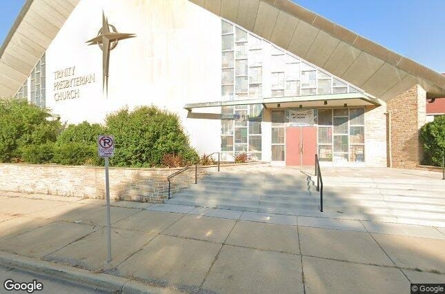
Property Record
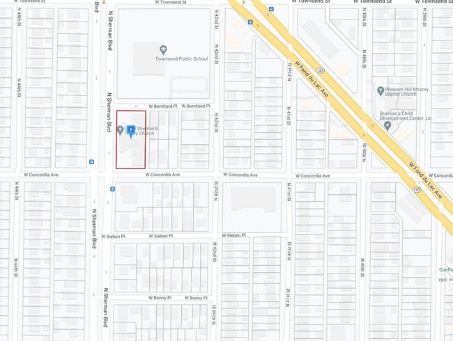
4218 W Concordia Ave, Milwaukee, WI 53216
NEARBY LISTINGS FOR SALE OR LEASE
Property Detail
4218 W Concordia Ave
Milwaukee-Waukesha-West Allis, WI
Bonny Park
287-0097-000-2
WOELKY SUBD IN SW 1/4 SEC 12-7-21 BLOCK 4 LOTS 7-8-9-10-11-12 & ALL EXC E 138 LOT 4 BLK 7 ADJ
Residentialnec
Milwaukee
X
Wisconsin
55079C0100E
7-8,4
2024
0.11 AC
2024
Milwaukee West
003800
Milwaukee/Madison
DEMOGRAPHICS near 4218 W Concordia Ave
1 Mile
3 Mile
5 Mile
2024 Total Population
27,736
213,393
481,347
2029 Population
27,354
211,068
473,538
Pop Growth 2024-2029
(1.38%)
(1.09%)
(1.62%)
Average Age
37
36
36
2024 Total Households
10,917
85,172
202,566
HH Growth 2024-2029
(1.50%)
(1.27%)
(1.64%)
Median Household Inc
$38,662
$40,120
$49,054
Avg Household Size
2.50
2.40
2.20
2024 Avg HH Vehicles
1.00
1.00
1.00
Median Home Value
$114,022
$138,756
$182,797
Median Year Built
1946
1948
1949
Nearby Places
- Restaurants
- Banks
- Shops
- Fitness
- Groceries
PUBLIC TRANSPORTATION
COMMUTER RAIL
Milwaukee (Empire Builder - Amtrak)
DRIVE
WALK
Distance
Milwaukee (Empire Builder - Amtrak)
12 min
4.4 mi
AIRPORT
General Mitchell International
DRIVE
WALK
Distance
General Mitchell International
22 min
11.0 mi
Freight Ports
Port Milwaukee
DRIVE
WALK
Distance
Port Milwaukee
15 min
6.8 mi
SALE & LEASE HISTORY
LISTING DATE
SALE/LEASE

Jan 02, 2024
For Sale
Nearby Properties
Address
Land Use
TOTAL SIZE
Lot Size
Zoning
Address
Land Use
TOTAL SIZE
Lot Size
Zoning
0.09 AC
LB2
Address
Land Use
TOTAL SIZE
Lot Size
Zoning
0.07 AC
RS6
Address
Land Use
TOTAL SIZE
Lot Size
Zoning
685,390 SF
26.20 AC
Address
Land Use
TOTAL SIZE
Lot Size
Zoning
12.74 AC
TL
Address
Land Use
TOTAL SIZE
Lot Size
Zoning
189,063 SF
2.35 AC
RED
Address
Land Use
TOTAL SIZE
Lot Size
Zoning
0.71 AC
RM2
Address
Land Use
TOTAL SIZE
Lot Size
Zoning
0.71 AC
RM2
Address
Land Use
TOTAL SIZE
Lot Size
Zoning
241,520 SF
6.60 AC
Address
Land Use
TOTAL SIZE
Lot Size
Zoning
9.33 AC
PUD
Address
Land Use
TOTAL SIZE
Lot Size
Zoning
3.74 AC
PUD
Address
Land Use
TOTAL SIZE
Lot Size
Zoning
1.76 AC
LB2
Address
Land Use
TOTAL SIZE
Lot Size
Zoning
92,402 SF
0.87 AC
RED
Address
Land Use
TOTAL SIZE
Lot Size
Zoning
8.78 AC
Address
Land Use
TOTAL SIZE
Lot Size
Zoning
4.25 AC
PD
Address
Land Use
TOTAL SIZE
Lot Size
Zoning
2.15 AC
RT4
Address
Land Use
TOTAL SIZE
Lot Size
Zoning
0.36 AC
Address
Land Use
TOTAL SIZE
Lot Size
Zoning
4.63 AC
IO2
Address
Land Use
TOTAL SIZE
Lot Size
Zoning
17.84 AC
TL
Address
Land Use
TOTAL SIZE
Lot Size
Zoning
169,550 SF
12.04 AC
RB2
Address
Land Use
TOTAL SIZE
Lot Size
Zoning
194,400 SF
8.09 AC
Address
Land Use
TOTAL SIZE
Lot Size
Zoning
18.54 AC
RS6
Address
Land Use
TOTAL SIZE
Lot Size
Zoning
6.74 AC
IL2
Address
Land Use
TOTAL SIZE
Lot Size
Zoning
3.41 AC
Address
Land Use
TOTAL SIZE
Lot Size
Zoning
0.51 AC
RT2
Address
Land Use
TOTAL SIZE
Lot Size
Zoning
118,400 SF
13.25 AC
IL2
Address
Land Use
TOTAL SIZE
Lot Size
Zoning
7.38 AC
TL
Address
Land Use
TOTAL SIZE
Lot Size
Zoning
7.84 AC
IH
Address
Land Use
TOTAL SIZE
Lot Size
Zoning
6.66 AC
RT3
Address
Land Use
TOTAL SIZE
Lot Size
Zoning
6.41 AC
RT4
Address
Land Use
TOTAL SIZE
Lot Size
Zoning
11.45 AC
RS6
The World's #1 Commercial Real Estate Marketplace
Connect with us
© 2025 CoStar Group
The information above has been obtained from sources believed reliable. While we do not doubt its accuracy we have not verified it and make no guarantee, warranty or representation about it. It is your responsibility to independently confirm its accuracy and completeness. Any projections, opinions, assumptions, or estimates used are for example only and do not represent the current or future performance of the property. The value of this transaction to you depends on tax and other factors which should be evaluated by your tax, financial, and legal advisors. You and your advisors should conduct a careful, independent investigation of the property to determine to your satisfaction the suitability of the property for your needs.