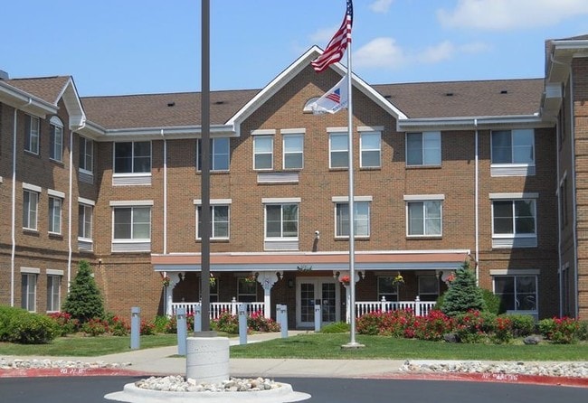
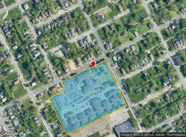
Property Record
4241 Burlingame St, Detroit, MI 48204
NEARBY LISTINGS FOR SALE OR LEASE
Property Detail
4241 Burlingame St
14-007029-003
W PETOSKY ALL THAT PT OF 1/4 SEC 29 TTAT DESC AS FOLS BEG AT INTEC OF SLY LINE OF BURLINGAME AVE, 50 FT WD,AND WLY LINE OF PETOSKY AVE, 50 FT WD, TH S 25D 13M 20S E 245.55 FT; TH S 64D 04M 28S W 481.29 FT TH N 25D 07M 44S W 45.27 FT; TH N 64D 52M 16S
Retirementnursinghomecombined
Wayne
X
Michigan
26163C0100E
2.60 AC
2025
North Detroit
2025
Detroit
530900
Detroit-Warren-Dearborn, MI
62,874 SF
DEMOGRAPHICS near 4241 Burlingame St
1 Mile
3 Mile
5 Mile
2024 Total Population
22,573
155,609
438,817
2029 Population
23,469
158,098
434,762
Pop Growth 2024-2029
+ 3.97%
+ 1.60%
(0.92%)
Average Age
39
38
37
2024 Total Households
9,646
63,011
166,417
HH Growth 2024-2029
+ 4.05%
+ 1.77%
(0.62%)
Median Household Inc
$30,655
$32,077
$35,635
Avg Household Size
2.30
2.40
2.50
2024 Avg HH Vehicles
1.00
1.00
1.00
Median Home Value
$78,553
$82,138
$89,709
Median Year Built
1946
1947
1948
Nearby Places
Map Layers
Map Styles
 Street
 Aerial
- Restaurants
- Banks
- Shops
- Fitness
- Groceries
PUBLIC TRANSPORTATION
COMMUTER RAIL
Detroit (Wolverine - Amtrak)
DRIVE
WALK
Distance
Detroit (Wolverine - Amtrak)
10 min
4.0 mi
AIRPORT
Windsor International
DRIVE
WALK
Distance
Windsor International
33 min
16.8 mi
Detroit Metro Wayne County
DRIVE
WALK
Distance
Detroit Metro Wayne County
35 min
21.2 mi
Freight Ports
Port of Toledo
DRIVE
WALK
Distance
Port of Toledo
79 min
63.3 mi
Nearby Properties
Address
Land Use
TOTAL SIZE
Lot Size
Zoning
Address
Land Use
TOTAL SIZE
Lot Size
Zoning
334,904 SF
B5
Address
Land Use
TOTAL SIZE
Lot Size
Zoning
506,450 SF
3.84 AC
B5
Address
Land Use
TOTAL SIZE
Lot Size
Zoning
266,016 SF
7.76 AC
PD
Address
Land Use
TOTAL SIZE
Lot Size
Zoning
783,976 SF
52.57 AC
M4
Address
Land Use
TOTAL SIZE
Lot Size
Zoning
152,232 SF
SD2
Address
Land Use
TOTAL SIZE
Lot Size
Zoning
531,360 SF
1.44 AC
B5
Address
Land Use
TOTAL SIZE
Lot Size
Zoning
678,539 SF
3.52 AC
B5
Address
Land Use
TOTAL SIZE
Lot Size
Zoning
164,797 SF
2.03 AC
Address
Land Use
TOTAL SIZE
Lot Size
Zoning
449,083 SF
2.39 AC
B2
Address
Land Use
TOTAL SIZE
Lot Size
Zoning
171,665 SF
3.73 AC
R5
Address
Land Use
TOTAL SIZE
Lot Size
Zoning
76,986 SF
2.73 AC
B4
Address
Land Use
TOTAL SIZE
Lot Size
Zoning
274,900 SF
M2
Address
Land Use
TOTAL SIZE
Lot Size
Zoning
520,522 SF
51.78 AC
M4
Address
Land Use
TOTAL SIZE
Lot Size
Zoning
135,296 SF
1.09 AC
R5
Address
Land Use
TOTAL SIZE
Lot Size
Zoning
263,240 SF
1.21 AC
B4
Address
Land Use
TOTAL SIZE
Lot Size
Zoning
185,944 SF
B2
Address
Land Use
TOTAL SIZE
Lot Size
Zoning
590,652 SF
21.79 AC
TM
Address
Land Use
TOTAL SIZE
Lot Size
Zoning
446,500 SF
27.90 AC
Address
Land Use
TOTAL SIZE
Lot Size
Zoning
224,410 SF
2.11 AC
M3
Address
Land Use
TOTAL SIZE
Lot Size
Zoning
214,306 SF
3.76 AC
R3
Address
Land Use
TOTAL SIZE
Lot Size
Zoning
65,140 SF
1.22 AC
B4
Address
Land Use
TOTAL SIZE
Lot Size
Zoning
Address
Land Use
TOTAL SIZE
Lot Size
Zoning
46,723 SF
B2
Address
Land Use
TOTAL SIZE
Lot Size
Zoning
58,261 SF
607 AC
B5
Address
Land Use
TOTAL SIZE
Lot Size
Zoning
261,677 SF
1.77 AC
M3
Address
Land Use
TOTAL SIZE
Lot Size
Zoning
75,870 SF
B5
Address
Land Use
TOTAL SIZE
Lot Size
Zoning
91,778 SF
10.19 AC
PD
Address
Land Use
TOTAL SIZE
Lot Size
Zoning
301,000 SF
Address
Land Use
TOTAL SIZE
Lot Size
Zoning
150,689 SF
4.87 AC
R5
Address
Land Use
TOTAL SIZE
Lot Size
Zoning
1,452 SF
19.24 AC
IC
The World's #1 Commercial Real Estate Marketplace
Connect with us
© 2026 CoStar Group
The information above has been obtained from sources believed reliable. While we do not doubt its accuracy we have not verified it and make no guarantee, warranty or representation about it. It is your responsibility to independently confirm its accuracy and completeness. Any projections, opinions, assumptions, or estimates used are for example only and do not represent the current or future performance of the property. The value of this transaction to you depends on tax and other factors which should be evaluated by your tax, financial, and legal advisors. You and your advisors should conduct a careful, independent investigation of the property to determine to your satisfaction the suitability of the property for your needs.