Property Record
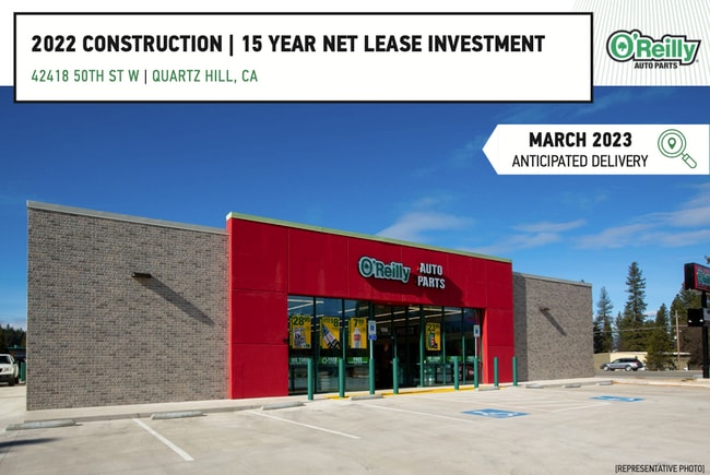
42418 50Th St W, Lancaster, CA 93536


Property Detail
42418 50Th St W
3103-004-052
TR=11728 EX OF STS LOT 88 AND POR OF LOT 87
Storemultistory
Los Angeles
LCMX-DRU
California
B and X Area of moderate flood hazard, usually the area between the limits of the 100-year and 500-year floods.
88,87
2025
1.34 AC
2025
Antelope Valley
901102
Los Angeles
7,396 SF
Los Angeles-Long Beach-Glendale, CA
NEARBY LISTINGS FOR SALE OR LEASE
-
-
View all Lancaster listings for sale on LoopNet.com
DEMOGRAPHICS near 42418 50Th St W
1 mile
3 mile
5 mile
2025 Total Population
10,441
71,235
126,825
2030 Population
10,351
71,193
127,337
Pop Growth 2025-2030
(0.86%)
(0.06%)
+ 0.40%
Average Age
38
40
39
2025 Total Households
3,418
23,120
42,344
HH Growth 2025-2030
(1.05%)
(0.25%)
+ 0.47%
Median Household Inc
$105,594
$110,201
$96,211
Avg Household Size
3.00
3.00
2.90
2025 Avg HH Vehicles
2.00
2.00
2.00
Median Home Value
$475,082
$599,491
$564,215
Median Year Built
1981
1992
1990
Nearby Places
Map Layers
Map Styles
 Street
 Aerial
Layers
 Traffic
 Biking
Places
Listings with unknown addresses are not visible on the map
- Restaurants
- Banks
- Shops
- Fitness
- Groceries
PUBLIC TRANSPORTATION
COMMUTER RAIL
Lancaster (Antelope Valley Line - Southern California Regional Rail Authority (Metrolink))
Drive
Walk
Distance
Lancaster (Antelope Valley Line - Southern California Regional Rail Authority (Metrolink))
13 min
7.8 mi
Palmdale (Antelope Valley Line - Southern California Regional Rail Authority (Metrolink))
Drive
Walk
Distance
Palmdale (Antelope Valley Line - Southern California Regional Rail Authority (Metrolink))
15 min
9.1 mi
SALE & LEASE HISTORY
LISTING DATE
SALE/LEASE

Sep 14, 2022
For Sale
Nov 10, 2022
For Sale
Mar 20, 2023
For Sale
Nearby Properties
Address
Land Use
TOTAL SIZE
Lot Size
Zoning
Address
Land Use
TOTAL SIZE
Lot Size
Zoning
107,924 SF
8.95 AC
LRRPD10000
Address
Land Use
TOTAL SIZE
Lot Size
Zoning
58,043 SF
5.94 AC
PDC3
Address
Land Use
TOTAL SIZE
Lot Size
Zoning
146,468 SF
7.41 AC
LRA22*
Address
Land Use
TOTAL SIZE
Lot Size
Zoning
62,739 SF
18.53 AC
LRA22
Address
Land Use
TOTAL SIZE
Lot Size
Zoning
46,328 SF
4.78 AC
LCR1 10000
Address
Land Use
TOTAL SIZE
Lot Size
Zoning
0.34 AC
LCA22*
Address
Land Use
TOTAL SIZE
Lot Size
Zoning
32.02 AC
LRSP
Address
Land Use
TOTAL SIZE
Lot Size
Zoning
47,294 SF
4.45 AC
LRR315U*
Address
Land Use
TOTAL SIZE
Lot Size
Zoning
41,550 SF
6.36 AC
LRRA10000*
Address
Land Use
TOTAL SIZE
Lot Size
Zoning
67,985 SF
3.34 AC
LCRA10000*
Address
Land Use
TOTAL SIZE
Lot Size
Zoning
43,255 SF
3.92 AC
LRC1DP*
Address
Land Use
TOTAL SIZE
Lot Size
Zoning
57,126 SF
4.78 AC
LRSP8101*
Address
Land Use
TOTAL SIZE
Lot Size
Zoning
13,565 SF
1.14 AC
PDLCC
Address
Land Use
TOTAL SIZE
Lot Size
Zoning
41,356 SF
4.76 AC
PDSP
Address
Land Use
TOTAL SIZE
Lot Size
Zoning
36,115 SF
13.25 AC
LCA210
Address
Land Use
TOTAL SIZE
Lot Size
Zoning
105,077 SF
13.27 AC
LCC1-LCR3*
Address
Land Use
TOTAL SIZE
Lot Size
Zoning
23,581 SF
4.81 AC
LRA22*
Address
Land Use
TOTAL SIZE
Lot Size
Zoning
72,584 SF
2.01 AC
LCR1 10000
Address
Land Use
TOTAL SIZE
Lot Size
Zoning
10,000 SF
1.48 AC
LCC2
Address
Land Use
TOTAL SIZE
Lot Size
Zoning
105,212 SF
19.15 AC
LRSRR*
Address
Land Use
TOTAL SIZE
Lot Size
Zoning
27,821 SF
1.09 AC
LCR3P*
Address
Land Use
TOTAL SIZE
Lot Size
Zoning
27,938 SF
3.81 AC
LRRA10000*
Address
Land Use
TOTAL SIZE
Lot Size
Zoning
2.37 AC
LRMDR*
Address
Land Use
TOTAL SIZE
Lot Size
Zoning
63,960 SF
2.37 AC
LRMDR*
Address
Land Use
TOTAL SIZE
Lot Size
Zoning
41,990 SF
1.21 AC
LCR1 10000
Address
Land Use
TOTAL SIZE
Lot Size
Zoning
15,108 SF
1.91 AC
LRCPD*
Address
Land Use
TOTAL SIZE
Lot Size
Zoning
138,009 SF
12.01 AC
LCR3*
Address
Land Use
TOTAL SIZE
Lot Size
Zoning
44,160 SF
5.51 AC
LCR3-2DU-D
Address
Land Use
TOTAL SIZE
Lot Size
Zoning
21,873 SF
3.38 AC
LCA22*
The World's #1 Commercial Real Estate Marketplace
Connect with us
© 2026 CoStar Group
The information above has been obtained from sources believed reliable. While we do not doubt its accuracy we have not verified it and make no guarantee, warranty or representation about it. It is your responsibility to independently confirm its accuracy and completeness. Any projections, opinions, assumptions, or estimates used are for example only and do not represent the current or future performance of the property. The value of this transaction to you depends on tax and other factors which should be evaluated by your tax, financial, and legal advisors. You and your advisors should conduct a careful, independent investigation of the property to determine to your satisfaction the suitability of the property for your needs.