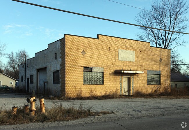
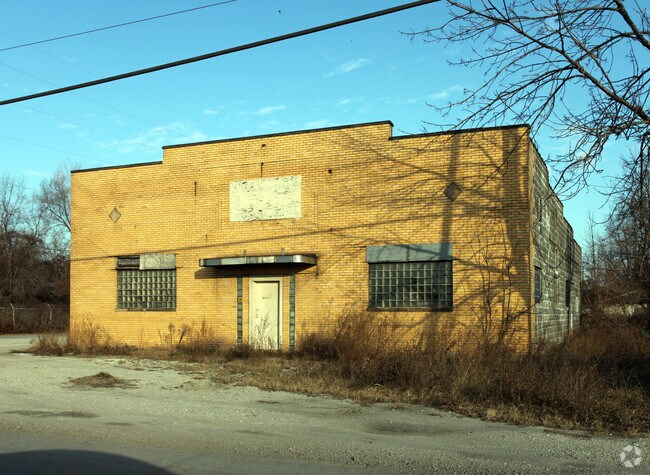
Property Record
4245 Bayshore Rd, Oregon, OH 43616

Save to a Folder
{{folder.Name}}
{{folder.ListingIds.length}} Properties
{{folder.ListingIds.length}} Property
Create a New Folder
Property Detail
4245 Bayshore Rd
44-57244
1ST EXT CASE FARM BCH LOTS 224 225 & 226
Parkingstructure
LUCAS
40-C5
Ohio
B and X Area of moderate flood hazard, usually the area between the limits of the 100-year and 500-year floods.
224
0
0.26 AC
2025
East Toledo/Oregon
009902
Toledo
3,200 SF
Toledo, OH
NEARBY LISTINGS FOR SALE OR LEASE
DEMOGRAPHICS near 4245 Bayshore Rd
1 mile
3 mile
5 mile
2025 Total Population
508
18,929
67,777
2030 Population
515
18,660
68,027
Pop Growth 2025-2030
+ 1.38%
(1.42%)
+ 0.37%
Average Age
41
42
40
2025 Total Households
201
7,749
27,866
HH Growth 2025-2030
+ 1.49%
(1.52%)
+ 0.22%
Median Household Inc
$35,278
$59,677
$49,711
Avg Household Size
2.50
2.30
2.30
2025 Avg HH Vehicles
2.00
2.00
2.00
Median Home Value
$202,419
$135,257
$128,102
Median Year Built
1951
1955
1956
Nearby Places
Map Layers
Map Styles
 Street
 Aerial
Layers
 Traffic
 Biking
Places
Listings with unknown addresses are not visible on the map
- Restaurants
- Banks
- Shops
- Fitness
- Groceries
PUBLIC TRANSPORTATION
COMMUTER RAIL
Drive
Walk
Distance
17 min
7.4 mi
AIRPORT
Eugene F Kranz Toledo Express
Drive
Walk
Distance
Eugene F Kranz Toledo Express
49 min
26.5 mi
Freight Ports
Drive
Walk
Distance
9 min
3.2 mi
Nearby Properties
Address
Land Use
TOTAL SIZE
Lot Size
Zoning
Address
Land Use
TOTAL SIZE
Lot Size
Zoning
286,525 SF
105.33 AC
10-RS6
Address
Land Use
TOTAL SIZE
Lot Size
Zoning
225,407 SF
128.05 AC
10-MX
Address
Land Use
TOTAL SIZE
Lot Size
Zoning
334,732 SF
516.10 AC
40-M2
Address
Land Use
TOTAL SIZE
Lot Size
Zoning
27.41 AC
40-CI
Address
Land Use
TOTAL SIZE
Lot Size
Zoning
150,000 SF
17.55 AC
40-CI
Address
Land Use
TOTAL SIZE
Lot Size
Zoning
187,988 SF
20 AC
40-M2
Address
Land Use
TOTAL SIZE
Lot Size
Zoning
29.92 AC
40-CI
Address
Land Use
TOTAL SIZE
Lot Size
Zoning
18,843 SF
30.05 AC
40-M2
Address
Land Use
TOTAL SIZE
Lot Size
Zoning
55,544 SF
13 AC
40-R2
Address
Land Use
TOTAL SIZE
Lot Size
Zoning
70,404 SF
8.07 AC
10-RS6
Address
Land Use
TOTAL SIZE
Lot Size
Zoning
454,080 SF
54.59 AC
10-IG
Address
Land Use
TOTAL SIZE
Lot Size
Zoning
398,978 SF
79.82 AC
40-M2
Address
Land Use
TOTAL SIZE
Lot Size
Zoning
47,907 SF
10.24 AC
40-A1
Address
Land Use
TOTAL SIZE
Lot Size
Zoning
127.78 AC
10-MX
Address
Land Use
TOTAL SIZE
Lot Size
Zoning
79,128 SF
9.01 AC
10-CRSO
Address
Land Use
TOTAL SIZE
Lot Size
Zoning
61,921 SF
48.79 AC
40-M2
Address
Land Use
TOTAL SIZE
Lot Size
Zoning
6,696 SF
81.72 AC
MARINA
Address
Land Use
TOTAL SIZE
Lot Size
Zoning
53,154 SF
9.75 AC
40-R2
Address
Land Use
TOTAL SIZE
Lot Size
Zoning
48,403 SF
3.80 AC
10-RD6
Address
Land Use
TOTAL SIZE
Lot Size
Zoning
35.77 AC
10-IG
Address
Land Use
TOTAL SIZE
Lot Size
Zoning
3,099 AC
40-R2
Address
Land Use
TOTAL SIZE
Lot Size
Zoning
173,969 SF
28.51 AC
40-CI
Address
Land Use
TOTAL SIZE
Lot Size
Zoning
101,724 SF
7.14 AC
40-CI
Address
Land Use
TOTAL SIZE
Lot Size
Zoning
81,345 SF
5.28 AC
40-CI
Address
Land Use
TOTAL SIZE
Lot Size
Zoning
82,628 SF
4.66 AC
40-CI
Address
Land Use
TOTAL SIZE
Lot Size
Zoning
11 AC
40-C1
Address
Land Use
TOTAL SIZE
Lot Size
Zoning
33,430 SF
160 AC
40-P
Address
Land Use
TOTAL SIZE
Lot Size
Zoning
63,000 SF
14.16 AC
40-CI
Address
Land Use
TOTAL SIZE
Lot Size
Zoning
43,904 SF
1.78 AC
10-CR
Address
Land Use
TOTAL SIZE
Lot Size
Zoning
31,741 SF
4.77 AC
10-MX
The World's #1 Commercial Real Estate Marketplace
Connect with us
© 2026 CoStar Group
The information above has been obtained from sources believed reliable. While we do not doubt its accuracy we have not verified it and make no guarantee, warranty or representation about it. It is your responsibility to independently confirm its accuracy and completeness. Any projections, opinions, assumptions, or estimates used are for example only and do not represent the current or future performance of the property. The value of this transaction to you depends on tax and other factors which should be evaluated by your tax, financial, and legal advisors. You and your advisors should conduct a careful, independent investigation of the property to determine to your satisfaction the suitability of the property for your needs.