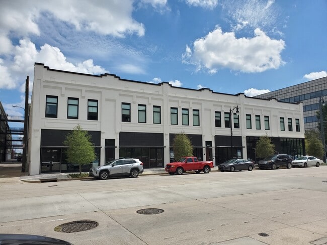
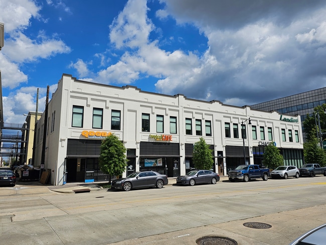
Property Record
425 20Th St S, Birmingham, AL 35233

Save to a Folder
{{folder.Name}}
{{folder.ListingIds.length}} Properties
{{folder.ListingIds.length}} Property
Create a New Folder
Property Detail
425 20Th St S
22-00-36-4-025-002.000
LOTS 11 THRU 14 BLK 162 BHAM
Apartment
JEFFERSON
B4
Alabama
B and X Area of moderate flood hazard, usually the area between the limits of the 100-year and 500-year floods.
11-14
2024
0.48 AC
2025
Southside
004502
Birmingham
22,580 SF
Birmingham, AL
NEARBY LISTINGS FOR SALE OR LEASE
DEMOGRAPHICS near 425 20Th St S
1 mile
3 mile
5 mile
2025 Total Population
15,308
84,422
176,383
2030 Population
15,544
85,094
177,213
Pop Growth 2025-2030
+ 1.54%
+ 0.80%
+ 0.47%
Average Age
32
38
39
2025 Total Households
6,859
38,285
76,110
HH Growth 2025-2030
+ 1.94%
+ 0.75%
+ 0.46%
Median Household Inc
$49,708
$50,785
$53,477
Avg Household Size
1.50
1.90
2.10
2025 Avg HH Vehicles
1.00
1.00
2.00
Median Home Value
$392,016
$391,601
$331,998
Median Year Built
1977
1965
1965
Nearby Places
Map Layers
Map Styles
 Street
 Aerial
Layers
 Traffic
 Biking
Places
Listings with unknown addresses are not visible on the map
- Restaurants
- Banks
- Shops
- Fitness
- Groceries
PUBLIC TRANSPORTATION
COMMUTER RAIL
Birmingham (Crescent - Amtrak)
Drive
Walk
Distance
Birmingham (Crescent - Amtrak)
1 min
11 min
0.6 mi
AIRPORT
Birmingham-Shuttlesworth International
Drive
Walk
Distance
Birmingham-Shuttlesworth International
9 min
5.6 mi
Freight Ports
Port of Mobile
Drive
Walk
Distance
Port of Mobile
279 min
255.7 mi
SALE & LEASE HISTORY
LISTING DATE
SALE/LEASE

Mar 17, 2021
For Lease
Nearby Properties
Address
Land Use
TOTAL SIZE
Lot Size
Zoning
Address
Land Use
TOTAL SIZE
Lot Size
Zoning
296,284 SF
12 AC
OI
Address
Land Use
TOTAL SIZE
Lot Size
Zoning
305,826 SF
4 AC
B4
Address
Land Use
TOTAL SIZE
Lot Size
Zoning
189,447 SF
4 AC
B4
Address
Land Use
TOTAL SIZE
Lot Size
Zoning
224,049 SF
4 AC
M1
Address
Land Use
TOTAL SIZE
Lot Size
Zoning
239,334 SF
4 AC
B6
Address
Land Use
TOTAL SIZE
Lot Size
Zoning
203,878 SF
13 AC
B6
Address
Land Use
TOTAL SIZE
Lot Size
Zoning
261,311 SF
21 AC
C1
Address
Land Use
TOTAL SIZE
Lot Size
Zoning
183,862 SF
10 AC
B4
Address
Land Use
TOTAL SIZE
Lot Size
Zoning
230,441 SF
10 AC
M1
Address
Land Use
TOTAL SIZE
Lot Size
Zoning
106,144 SF
1 AC
B4
Address
Land Use
TOTAL SIZE
Lot Size
Zoning
94,958 SF
4 AC
M1
Address
Land Use
TOTAL SIZE
Lot Size
Zoning
334,463 SF
2 AC
B4
Address
Land Use
TOTAL SIZE
Lot Size
Zoning
154,474 SF
12.50 AC
R-D
Address
Land Use
TOTAL SIZE
Lot Size
Zoning
57,066 SF
1 AC
B4
Address
Land Use
TOTAL SIZE
Lot Size
Zoning
46,161 SF
1 AC
M1-B
Address
Land Use
TOTAL SIZE
Lot Size
Zoning
95,993 SF
3.67 AC
M1
Address
Land Use
TOTAL SIZE
Lot Size
Zoning
229,669 SF
2.75 AC
B4
Address
Land Use
TOTAL SIZE
Lot Size
Zoning
109,411 SF
3 AC
B4
Address
Land Use
TOTAL SIZE
Lot Size
Zoning
344,150 SF
42 AC
R5
Address
Land Use
TOTAL SIZE
Lot Size
Zoning
2 AC
M1-B
Address
Land Use
TOTAL SIZE
Lot Size
Zoning
1,666 SF
2 AC
M1
Address
Land Use
TOTAL SIZE
Lot Size
Zoning
30,453 SF
0.87 AC
B2
Address
Land Use
TOTAL SIZE
Lot Size
Zoning
2 AC
B4
Address
Land Use
TOTAL SIZE
Lot Size
Zoning
29,136 SF
2 AC
B4
Address
Land Use
TOTAL SIZE
Lot Size
Zoning
79,458 SF
1 AC
B4
Address
Land Use
TOTAL SIZE
Lot Size
Zoning
143,200 SF
23.49 AC
R3/O
Address
Land Use
TOTAL SIZE
Lot Size
Zoning
416,477 SF
80 AC
R5
Address
Land Use
TOTAL SIZE
Lot Size
Zoning
109,819 SF
2.91 AC
M2
Address
Land Use
TOTAL SIZE
Lot Size
Zoning
62,350 SF
1.29 AC
B-4
Address
Land Use
TOTAL SIZE
Lot Size
Zoning
156,986 SF
1.29 AC
M1
The World's #1 Commercial Real Estate Marketplace
Connect with us
© 2026 CoStar Group
The information above has been obtained from sources believed reliable. While we do not doubt its accuracy we have not verified it and make no guarantee, warranty or representation about it. It is your responsibility to independently confirm its accuracy and completeness. Any projections, opinions, assumptions, or estimates used are for example only and do not represent the current or future performance of the property. The value of this transaction to you depends on tax and other factors which should be evaluated by your tax, financial, and legal advisors. You and your advisors should conduct a careful, independent investigation of the property to determine to your satisfaction the suitability of the property for your needs.