Property Record
425 3Rd Pl, Manhattan, KS 66502

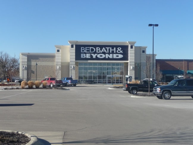
Property Detail
425 3Rd Pl
Manhattan, KS
MANHATTAN MARKETPLACE SHOPS #3, LOT 1, 80860 SQUARE FEET
204-18-2-10-20-005.00-0
RILEY
Wholesaleoutletdiscountstore
Kansas
PUD
1
2024
2.37 AC
2025
Kansas Area
000801
Other Market Areas
30,016 SF
NEARBY LISTINGS FOR SALE OR LEASE
DEMOGRAPHICS near 425 3Rd Pl
1 mile
3 mile
5 mile
2025 Total Population
8,574
41,451
62,431
2030 Population
8,754
41,920
63,261
Pop Growth 2025-2030
+ 2.10%
+ 1.13%
+ 1.33%
Average Age
30
31
34
2025 Total Households
4,223
16,177
24,450
HH Growth 2025-2030
+ 2.04%
+ 1.27%
+ 1.36%
Median Household Inc
$33,738
$49,124
$64,414
Avg Household Size
1.90
2.10
2.20
2025 Avg HH Vehicles
2.00
2.00
2.00
Median Home Value
$166,559
$197,037
$264,269
Median Year Built
1970
1977
1983
Nearby Places
Map Layers
Map Styles
 Street
 Aerial
Transit
 Traffic
 Biking
Places
Listings with unknown addresses are not visible on the map
- Restaurants
- Banks
- Shops
- Fitness
- Groceries
Nearby Properties
Address
Land Use
TOTAL SIZE
Lot Size
Zoning
Address
Land Use
TOTAL SIZE
Lot Size
Zoning
45.61 AC
U
Address
Land Use
TOTAL SIZE
Lot Size
Zoning
4,748,887 SF
261.83 AC
U
Address
Land Use
TOTAL SIZE
Lot Size
Zoning
125.53 AC
U
Address
Land Use
TOTAL SIZE
Lot Size
Zoning
1,084,753 SF
69.85 AC
U
Address
Land Use
TOTAL SIZE
Lot Size
Zoning
518,756 SF
11.88 AC
U
Address
Land Use
TOTAL SIZE
Lot Size
Zoning
69,440 SF
27.76 AC
U
Address
Land Use
TOTAL SIZE
Lot Size
Zoning
41,664 SF
22.69 AC
U
Address
Land Use
TOTAL SIZE
Lot Size
Zoning
132.41 AC
U
Address
Land Use
TOTAL SIZE
Lot Size
Zoning
347,291 SF
21.20 AC
R
Address
Land Use
TOTAL SIZE
Lot Size
Zoning
114,793 SF
9.46 AC
U
Address
Land Use
TOTAL SIZE
Lot Size
Zoning
13,351 SF
23.80 AC
R1
Address
Land Use
TOTAL SIZE
Lot Size
Zoning
10,315 SF
128.74 AC
U
Address
Land Use
TOTAL SIZE
Lot Size
Zoning
77,295 SF
4.30 AC
U
Address
Land Use
TOTAL SIZE
Lot Size
Zoning
95,188 SF
6.34 AC
R1
Address
Land Use
TOTAL SIZE
Lot Size
Zoning
29,816 SF
2.09 AC
C4
Address
Land Use
TOTAL SIZE
Lot Size
Zoning
126,616 SF
28.60 AC
R1
Address
Land Use
TOTAL SIZE
Lot Size
Zoning
1,920 SF
4.47 AC
Address
Land Use
TOTAL SIZE
Lot Size
Zoning
71,182 SF
11.80 AC
R
Address
Land Use
TOTAL SIZE
Lot Size
Zoning
40,076 SF
1.27 AC
PUD
Address
Land Use
TOTAL SIZE
Lot Size
Zoning
89,898 SF
5.48 AC
R3
Address
Land Use
TOTAL SIZE
Lot Size
Zoning
46,653 SF
0.85 AC
U
Address
Land Use
TOTAL SIZE
Lot Size
Zoning
71,899 SF
5.50 AC
R
Address
Land Use
TOTAL SIZE
Lot Size
Zoning
32,402 SF
5.76 AC
R
Address
Land Use
TOTAL SIZE
Lot Size
Zoning
34,319 SF
1.77 AC
C1
Address
Land Use
TOTAL SIZE
Lot Size
Zoning
67,276 SF
9 AC
R
Address
Land Use
TOTAL SIZE
Lot Size
Zoning
72,326 SF
4.83 AC
R
Address
Land Use
TOTAL SIZE
Lot Size
Zoning
44,800 SF
4.49 AC
Address
Land Use
TOTAL SIZE
Lot Size
Zoning
9,754 SF
2 AC
PUD
Address
Land Use
TOTAL SIZE
Lot Size
Zoning
25,505 SF
2.46 AC
U
Address
Land Use
TOTAL SIZE
Lot Size
Zoning
50,784 SF
2.66 AC
U
The World's #1 Commercial Real Estate Marketplace
Connect with us
© 2026 CoStar Group
The information above has been obtained from sources believed reliable. While we do not doubt its accuracy we have not verified it and make no guarantee, warranty or representation about it. It is your responsibility to independently confirm its accuracy and completeness. Any projections, opinions, assumptions, or estimates used are for example only and do not represent the current or future performance of the property. The value of this transaction to you depends on tax and other factors which should be evaluated by your tax, financial, and legal advisors. You and your advisors should conduct a careful, independent investigation of the property to determine to your satisfaction the suitability of the property for your needs.