Property Record
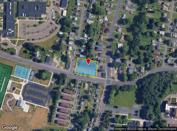
425 Osgood Ave, New Britain, CT 06053
NEARBY LISTINGS FOR SALE OR LEASE
Property Detail
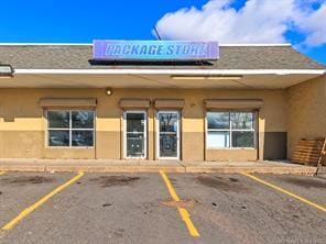
425 Osgood Ave
Commercialbuilding
Hartford
X
Connecticut
09003C0491F
0.79 AC
2025
New Britain
2025
Hartford
416700
Hartford-West Hartford-East Hartford, CT
8,000 SF
NBRI-000003C-000000-D000120
DEMOGRAPHICS near 425 Osgood Ave
1 Mile
3 Mile
5 Mile
2024 Total Population
16,053
84,077
162,646
2029 Population
15,863
83,337
161,360
Pop Growth 2024-2029
(1.18%)
(0.88%)
(0.79%)
Average Age
38
39
41
2024 Total Households
6,325
33,079
66,120
HH Growth 2024-2029
(1.25%)
(0.87%)
(0.80%)
Median Household Inc
$52,971
$56,427
$71,447
Avg Household Size
2.40
2.40
2.30
2024 Avg HH Vehicles
2.00
2.00
2.00
Median Home Value
$162,029
$195,638
$248,557
Median Year Built
1956
1956
1961
Nearby Places
Map Layers
Map Styles
 Street
 Aerial
- Restaurants
- Banks
- Shops
- Fitness
- Groceries
PUBLIC TRANSPORTATION
COMMUTER RAIL
DRIVE
WALK
Distance
10 min
5.0 mi
DRIVE
WALK
Distance
10 min
5.0 mi
AIRPORT
Bradley International
DRIVE
WALK
Distance
Bradley International
42 min
26.2 mi
Tweed/New Haven
DRIVE
WALK
Distance
Tweed/New Haven
52 min
34.9 mi
Freight Ports
Port of New Haven
DRIVE
WALK
Distance
Port of New Haven
47 min
33.8 mi
SALE & LEASE HISTORY
LISTING DATE
SALE/LEASE

Sep 23, 2016
For Sale
Nov 22, 2021
For Lease
Mar 05, 2020
For Lease
Jul 17, 2021
For Lease
Feb 08, 2020
For Lease
Feb 07, 2023
For Lease
Nearby Properties
Address
Land Use
TOTAL SIZE
Lot Size
Zoning
Address
Land Use
TOTAL SIZE
Lot Size
Zoning
146,740 SF
18.23 AC
TPC
Address
Land Use
TOTAL SIZE
Lot Size
Zoning
23.64 AC
S3
Address
Land Use
TOTAL SIZE
Lot Size
Zoning
131.09 AC
OP
Address
Land Use
TOTAL SIZE
Lot Size
Zoning
19.60 AC
S2
Address
Land Use
TOTAL SIZE
Lot Size
Zoning
134,488 SF
63.26 AC
GC
Address
Land Use
TOTAL SIZE
Lot Size
Zoning
138.27 AC
S1
Address
Land Use
TOTAL SIZE
Lot Size
Zoning
64,822 SF
9.47 AC
TP
Address
Land Use
TOTAL SIZE
Lot Size
Zoning
155,161 SF
18.18 AC
S1
Address
Land Use
TOTAL SIZE
Lot Size
Zoning
2.07 AC
CBD
Address
Land Use
TOTAL SIZE
Lot Size
Zoning
23.62 AC
A3
Address
Land Use
TOTAL SIZE
Lot Size
Zoning
117,139 SF
6.77 AC
T
Address
Land Use
TOTAL SIZE
Lot Size
Zoning
90,625 SF
0.97 AC
CBD
Address
Land Use
TOTAL SIZE
Lot Size
Zoning
96,238 SF
6.75 AC
T
Address
Land Use
TOTAL SIZE
Lot Size
Zoning
14.68 AC
SIF
Address
Land Use
TOTAL SIZE
Lot Size
Zoning
2.46 AC
CBD
Address
Land Use
TOTAL SIZE
Lot Size
Zoning
33.36 AC
T
Address
Land Use
TOTAL SIZE
Lot Size
Zoning
162,470 SF
27.10 AC
R40
Address
Land Use
TOTAL SIZE
Lot Size
Zoning
78,109 SF
8.22 AC
T
Address
Land Use
TOTAL SIZE
Lot Size
Zoning
112,304 SF
10.39 AC
S3
Address
Land Use
TOTAL SIZE
Lot Size
Zoning
16.94 AC
C1
Address
Land Use
TOTAL SIZE
Lot Size
Zoning
14,364 SF
2.72 AC
S3
Address
Land Use
TOTAL SIZE
Lot Size
Zoning
89,544 SF
6.20 AC
S1
Address
Land Use
TOTAL SIZE
Lot Size
Zoning
74,670 SF
4.46 AC
S2
Address
Land Use
TOTAL SIZE
Lot Size
Zoning
78,132 SF
11.76 AC
S2
Address
Land Use
TOTAL SIZE
Lot Size
Zoning
83,464 SF
13.96 AC
T
Address
Land Use
TOTAL SIZE
Lot Size
Zoning
10.10 AC
RDM
Address
Land Use
TOTAL SIZE
Lot Size
Zoning
121,775 SF
19.61 AC
PR
Address
Land Use
TOTAL SIZE
Lot Size
Zoning
183,626 SF
12.72 AC
UI
Address
Land Use
TOTAL SIZE
Lot Size
Zoning
4.43 AC
B3/A2
Address
Land Use
TOTAL SIZE
Lot Size
Zoning
69,025 SF
10.90 AC
S2
The World's #1 Commercial Real Estate Marketplace
Connect with us
© 2025 CoStar Group
The information above has been obtained from sources believed reliable. While we do not doubt its accuracy we have not verified it and make no guarantee, warranty or representation about it. It is your responsibility to independently confirm its accuracy and completeness. Any projections, opinions, assumptions, or estimates used are for example only and do not represent the current or future performance of the property. The value of this transaction to you depends on tax and other factors which should be evaluated by your tax, financial, and legal advisors. You and your advisors should conduct a careful, independent investigation of the property to determine to your satisfaction the suitability of the property for your needs.