Property Record
425 E John St, Lindenhurst, NY 11757
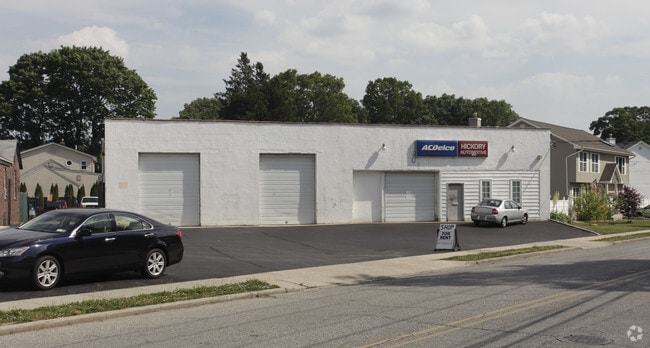

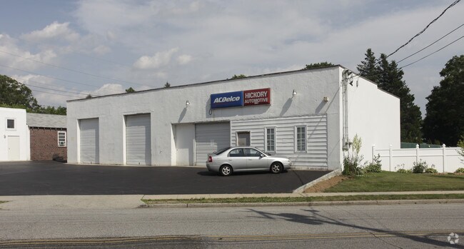
Property Detail
425 E John St
Nassau County-Suffolk County, NY
FILED MAP 840 SEC 2 LOTS 212-217 INC.
0103-012-00-02-00-026-000
Suffolk
Vehiclerentalsvehiclesales
New York
B and X Area of moderate flood hazard, usually the area between the limits of the 100-year and 500-year floods.
26
2024
0.75 AC
2024
Southwest Suffolk
124002
Long Island (New York)
NEARBY LISTINGS FOR SALE OR LEASE
DEMOGRAPHICS near 425 E John St
1 mile
3 mile
5 mile
2025 Total Population
18,340
130,968
270,880
2030 Population
17,970
128,556
267,242
Pop Growth 2025-2030
(2.02%)
(1.84%)
(1.34%)
Average Age
42
41
41
2025 Total Households
6,425
42,827
88,698
HH Growth 2025-2030
(2.29%)
(2.12%)
(1.57%)
Median Household Inc
$122,746
$125,297
$129,120
Avg Household Size
2.80
2.90
2.90
2025 Avg HH Vehicles
2.00
2.00
2.00
Median Home Value
$582,201
$580,012
$609,050
Median Year Built
1961
1960
1960
Nearby Places
Map Layers
Map Styles
 Street
 Aerial
Transit
 Traffic
 Biking
Places
Listings with unknown addresses are not visible on the map
- Restaurants
- Banks
- Shops
- Fitness
- Groceries
PUBLIC TRANSPORTATION
TRANSIT/SUBWAY
Lindenhurst Station (Babylon Branch - Long Island Rail Road)
Drive
Walk
Distance
Lindenhurst Station (Babylon Branch - Long Island Rail Road)
3 min
18 min
1.0 mi
COMMUTER RAIL
Lindenhurst Station (Babylon Branch - Long Island Rail Road)
Drive
Walk
Distance
Lindenhurst Station (Babylon Branch - Long Island Rail Road)
3 min
18 min
1.0 mi
Babylon Station (Babylon Branch - Long Island Rail Road, Montauk Branch - Long Island Rail Road)
Drive
Walk
Distance
Babylon Station (Babylon Branch - Long Island Rail Road, Montauk Branch - Long Island Rail Road)
5 min
2.2 mi
AIRPORT
Long Island MacArthur
Drive
Walk
Distance
Long Island MacArthur
29 min
18.6 mi
John F Kennedy International
Drive
Walk
Distance
John F Kennedy International
39 min
26.3 mi
LaGuardia
Drive
Walk
Distance
LaGuardia
49 min
33.3 mi
Freight Ports
NY - Red Hook Container Terminal
Drive
Walk
Distance
NY - Red Hook Container Terminal
60 min
37.7 mi
SALE & LEASE HISTORY
LISTING DATE
SALE/LEASE

Nov 09, 2017
For Sale
Nearby Properties
Address
Land Use
TOTAL SIZE
Lot Size
Zoning
Address
Land Use
TOTAL SIZE
Lot Size
Zoning
4,290 SF
1.50 AC
VILLA
Address
Land Use
TOTAL SIZE
Lot Size
Zoning
9.95 AC
BUS3
Address
Land Use
TOTAL SIZE
Lot Size
Zoning
18.70 AC
A
Address
Land Use
TOTAL SIZE
Lot Size
Zoning
14.60 AC
A
Address
Land Use
TOTAL SIZE
Lot Size
Zoning
24.90 AC
B
Address
Land Use
TOTAL SIZE
Lot Size
Zoning
9.70 AC
B
Address
Land Use
TOTAL SIZE
Lot Size
Zoning
19.40 AC
IND1
Address
Land Use
TOTAL SIZE
Lot Size
Zoning
5,821 SF
0.65 AC
CR60
Address
Land Use
TOTAL SIZE
Lot Size
Zoning
6.37 AC
BUS3
Address
Land Use
TOTAL SIZE
Lot Size
Zoning
2,520 SF
0.89 AC
HC
Address
Land Use
TOTAL SIZE
Lot Size
Zoning
1.70 AC
R40
Address
Land Use
TOTAL SIZE
Lot Size
Zoning
1.82 AC
Address
Land Use
TOTAL SIZE
Lot Size
Zoning
2.40 AC
A
Address
Land Use
TOTAL SIZE
Lot Size
Zoning
4.06 AC
BUS1
Address
Land Use
TOTAL SIZE
Lot Size
Zoning
5,010 SF
0.30 AC
R10
Address
Land Use
TOTAL SIZE
Lot Size
Zoning
0.99 AC
HB
Address
Land Use
TOTAL SIZE
Lot Size
Zoning
6,891 SF
0.75 AC
HC
Address
Land Use
TOTAL SIZE
Lot Size
Zoning
400 AC
A
Address
Land Use
TOTAL SIZE
Lot Size
Zoning
2.69 AC
BUS1
Address
Land Use
TOTAL SIZE
Lot Size
Zoning
2.38 AC
Address
Land Use
TOTAL SIZE
Lot Size
Zoning
13.63 AC
B
Address
Land Use
TOTAL SIZE
Lot Size
Zoning
3.44 AC
AA
Address
Land Use
TOTAL SIZE
Lot Size
Zoning
0.65 AC
R40
Address
Land Use
TOTAL SIZE
Lot Size
Zoning
Address
Land Use
TOTAL SIZE
Lot Size
Zoning
44 AC
E
Address
Land Use
TOTAL SIZE
Lot Size
Zoning
2.24 AC
Address
Land Use
TOTAL SIZE
Lot Size
Zoning
2.10 AC
IND1
Address
Land Use
TOTAL SIZE
Lot Size
Zoning
9.68 AC
SC
Address
Land Use
TOTAL SIZE
Lot Size
Zoning
3.80 AC
BUS1
Address
Land Use
TOTAL SIZE
Lot Size
Zoning
114.70 AC
A
The World's #1 Commercial Real Estate Marketplace
Connect with us
© 2026 CoStar Group
The information above has been obtained from sources believed reliable. While we do not doubt its accuracy we have not verified it and make no guarantee, warranty or representation about it. It is your responsibility to independently confirm its accuracy and completeness. Any projections, opinions, assumptions, or estimates used are for example only and do not represent the current or future performance of the property. The value of this transaction to you depends on tax and other factors which should be evaluated by your tax, financial, and legal advisors. You and your advisors should conduct a careful, independent investigation of the property to determine to your satisfaction the suitability of the property for your needs.