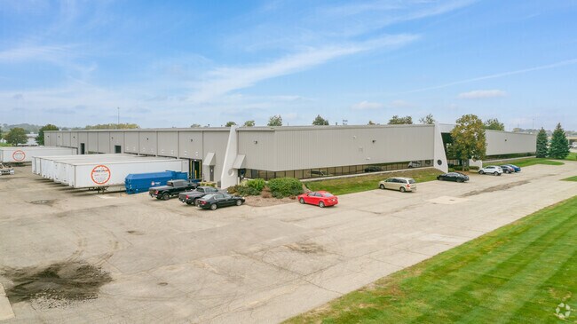
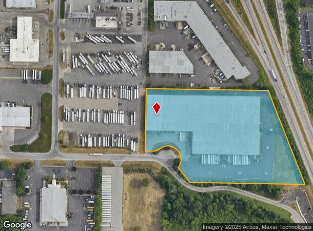
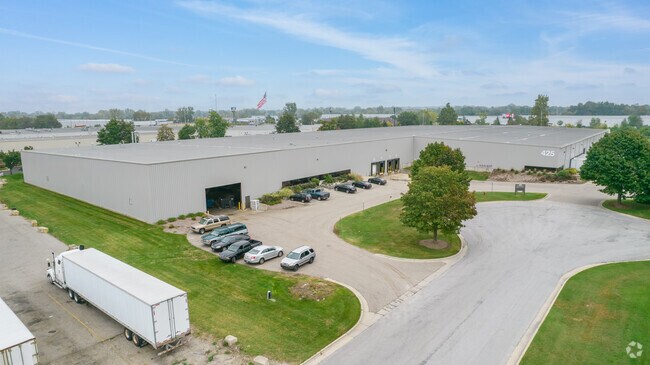
Property Record
425 Gordon Industrial Ct Sw, Byron Center, MI 49315
NEARBY LISTINGS FOR SALE OR LEASE
Property Detail
425 Gordon Industrial Ct Sw
Grand Rapids-Wyoming, MI
Gordon Industrial Square
41-21-13-100-086
LOTS 12 & 13 * GORDON INDUSTRIAL SQUARE
Commercialnec
Kent
X
Michigan
26005C0125G
12-13
2024
8.55 AC
2025
Byron/Gaines
014605
West Michigan
173,875 SF
DEMOGRAPHICS near 425 Gordon Industrial Ct Sw
1 Mile
3 Mile
5 Mile
2024 Total Population
4,202
45,459
114,442
2029 Population
4,244
45,889
115,728
Pop Growth 2024-2029
+ 1.00%
+ 0.95%
+ 1.12%
Average Age
39
38
38
2024 Total Households
1,628
16,998
41,977
HH Growth 2024-2029
+ 1.04%
+ 0.96%
+ 1.12%
Median Household Inc
$66,034
$71,416
$71,570
Avg Household Size
2.60
2.60
2.70
2024 Avg HH Vehicles
2.00
2.00
2.00
Median Home Value
$213,957
$256,639
$239,772
Median Year Built
1991
1992
1986
Nearby Places
Map Layers
Map Styles
 Street
 Aerial
- Restaurants
- Banks
- Shops
- Fitness
- Groceries
PUBLIC TRANSPORTATION
COMMUTER RAIL
Grand Rapids Vernon J. Ehlers Station (Pere Marquette - Amtrak)
DRIVE
WALK
Distance
Grand Rapids Vernon J. Ehlers Station (Pere Marquette - Amtrak)
12 min
9.9 mi
AIRPORT
Gerald R Ford International
DRIVE
WALK
Distance
Gerald R Ford International
20 min
11.8 mi
Freight Ports
Port Milwaukee
DRIVE
WALK
Distance
Port Milwaukee
305 min
260.9 mi
SALE & LEASE HISTORY
LISTING DATE
SALE/LEASE

Feb 08, 2021
For Lease
Nearby Properties
Address
Land Use
TOTAL SIZE
Lot Size
Zoning
Address
Land Use
TOTAL SIZE
Lot Size
Zoning
290,627 SF
Address
Land Use
TOTAL SIZE
Lot Size
Zoning
490,769 SF
42.25 AC
B3
Address
Land Use
TOTAL SIZE
Lot Size
Zoning
295,027 SF
51.42 AC
I3
Address
Land Use
TOTAL SIZE
Lot Size
Zoning
63,788 SF
124.62 AC
D1
Address
Land Use
TOTAL SIZE
Lot Size
Zoning
48.43 AC
PUD-PL UNI
Address
Land Use
TOTAL SIZE
Lot Size
Zoning
487,739 SF
73.87 AC
RR
Address
Land Use
TOTAL SIZE
Lot Size
Zoning
26.94 AC
Address
Land Use
TOTAL SIZE
Lot Size
Zoning
Address
Land Use
TOTAL SIZE
Lot Size
Zoning
38.98 AC
PUD-PL UNI
Address
Land Use
TOTAL SIZE
Lot Size
Zoning
Address
Land Use
TOTAL SIZE
Lot Size
Zoning
386,450 SF
29.10 AC
Address
Land Use
TOTAL SIZE
Lot Size
Zoning
465,772 SF
61.95 AC
I1
Address
Land Use
TOTAL SIZE
Lot Size
Zoning
58.30 AC
RA
Address
Land Use
TOTAL SIZE
Lot Size
Zoning
20.50 AC
RR
Address
Land Use
TOTAL SIZE
Lot Size
Zoning
2,593 SF
18 AC
PUD-PL UNI
Address
Land Use
TOTAL SIZE
Lot Size
Zoning
720 SF
74.47 AC
R4-MOBILE
Address
Land Use
TOTAL SIZE
Lot Size
Zoning
57,030 SF
17.74 AC
R3-MED RES
Address
Land Use
TOTAL SIZE
Lot Size
Zoning
108,911 SF
10.80 AC
D1
Address
Land Use
TOTAL SIZE
Lot Size
Zoning
16.30 AC
I1
Address
Land Use
TOTAL SIZE
Lot Size
Zoning
291,759 SF
26.01 AC
I3
Address
Land Use
TOTAL SIZE
Lot Size
Zoning
1,296 SF
12 AC
PUD-PL UNI
Address
Land Use
TOTAL SIZE
Lot Size
Zoning
30 AC
RS
Address
Land Use
TOTAL SIZE
Lot Size
Zoning
20.53 AC
Address
Land Use
TOTAL SIZE
Lot Size
Zoning
140,742 SF
18.57 AC
D1
Address
Land Use
TOTAL SIZE
Lot Size
Zoning
49.29 AC
R4-MOBILE
Address
Land Use
TOTAL SIZE
Lot Size
Zoning
30,869 SF
5.06 AC
PUD3
Address
Land Use
TOTAL SIZE
Lot Size
Zoning
Address
Land Use
TOTAL SIZE
Lot Size
Zoning
48.57 AC
RD
Address
Land Use
TOTAL SIZE
Lot Size
Zoning
45.66 AC
RD
Address
Land Use
TOTAL SIZE
Lot Size
Zoning
111,811 SF
5.70 AC
I3
The World's #1 Commercial Real Estate Marketplace
Connect with us
© 2025 CoStar Group
The information above has been obtained from sources believed reliable. While we do not doubt its accuracy we have not verified it and make no guarantee, warranty or representation about it. It is your responsibility to independently confirm its accuracy and completeness. Any projections, opinions, assumptions, or estimates used are for example only and do not represent the current or future performance of the property. The value of this transaction to you depends on tax and other factors which should be evaluated by your tax, financial, and legal advisors. You and your advisors should conduct a careful, independent investigation of the property to determine to your satisfaction the suitability of the property for your needs.