Property Record
425 John Ward Rd, Lexington, NC 27295
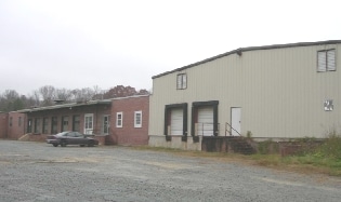


Property Detail
425 John Ward Rd
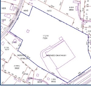
11-325-0-000-0030-0-0-0
L30 BK2051-975 US 29-70
Publicstorage
Davidson
OI
North Carolina
B and X Area of moderate flood hazard, usually the area between the limits of the 100-year and 500-year floods.
17.21 AC
2025
South Davidson County
2025
Greensboro/Winston-Salem
061204
Winston-Salem, NC
22,500 SF
NEARBY LISTINGS FOR SALE OR LEASE
DEMOGRAPHICS near 425 John Ward Rd
1 mile
3 mile
5 mile
2025 Total Population
853
13,299
39,025
2030 Population
904
14,092
41,198
Pop Growth 2025-2030
+ 5.98%
+ 5.96%
+ 5.57%
Average Age
41
40
41
2025 Total Households
348
5,258
15,763
HH Growth 2025-2030
+ 6.03%
+ 6.20%
+ 5.67%
Median Household Inc
$43,388
$48,403
$54,885
Avg Household Size
2.40
2.40
2.40
2025 Avg HH Vehicles
3.00
2.00
2.00
Median Home Value
$165,254
$190,898
$196,872
Median Year Built
1983
1976
1978
Nearby Places
Map Layers
Map Styles
 Street
 Aerial
Layers
 Traffic
 Biking
Places
Listings with unknown addresses are not visible on the map
- Restaurants
- Banks
- Shops
- Fitness
- Groceries
PUBLIC TRANSPORTATION
AIRPORT
Piedmont Triad International
Drive
Walk
Distance
Piedmont Triad International
44 min
28.6 mi
Freight Ports
Port of Wilmington
Drive
Walk
Distance
Port of Wilmington
259 min
214.7 mi
Nearby Properties
Address
Land Use
TOTAL SIZE
Lot Size
Zoning
Address
Land Use
TOTAL SIZE
Lot Size
Zoning
30,192 SF
82.73 AC
OI
Address
Land Use
TOTAL SIZE
Lot Size
Zoning
4,788 SF
11.95 AC
HC
Address
Land Use
TOTAL SIZE
Lot Size
Zoning
2,736 SF
4.77 AC
U
Address
Land Use
TOTAL SIZE
Lot Size
Zoning
20,651 SF
12.03 AC
B
Address
Land Use
TOTAL SIZE
Lot Size
Zoning
33,282 SF
4.41 AC
B
Address
Land Use
TOTAL SIZE
Lot Size
Zoning
8,008 SF
9.26 AC
TN
Address
Land Use
TOTAL SIZE
Lot Size
Zoning
45,732 SF
5.82 AC
LI
Address
Land Use
TOTAL SIZE
Lot Size
Zoning
85,425 SF
1.16 AC
U
Address
Land Use
TOTAL SIZE
Lot Size
Zoning
115,748 SF
8.14 AC
B
Address
Land Use
TOTAL SIZE
Lot Size
Zoning
128 SF
107.80 AC
PD
Address
Land Use
TOTAL SIZE
Lot Size
Zoning
115,600 SF
13.15 AC
I
Address
Land Use
TOTAL SIZE
Lot Size
Zoning
2,414 SF
16.14 AC
TN
Address
Land Use
TOTAL SIZE
Lot Size
Zoning
91,758 SF
12.07 AC
B
Address
Land Use
TOTAL SIZE
Lot Size
Zoning
18,986 SF
6.79 AC
TN
Address
Land Use
TOTAL SIZE
Lot Size
Zoning
135,603 SF
3.76 AC
TN
Address
Land Use
TOTAL SIZE
Lot Size
Zoning
41,784 SF
12.77 AC
OI
Address
Land Use
TOTAL SIZE
Lot Size
Zoning
14,648 SF
15.93 AC
OI
Address
Land Use
TOTAL SIZE
Lot Size
Zoning
9,054 SF
24.77 AC
TN
Address
Land Use
TOTAL SIZE
Lot Size
Zoning
36,014 SF
0.73 AC
U
Address
Land Use
TOTAL SIZE
Lot Size
Zoning
35,396 SF
10.31 AC
I
Address
Land Use
TOTAL SIZE
Lot Size
Zoning
7,080 SF
364.78 AC
RA3
Address
Land Use
TOTAL SIZE
Lot Size
Zoning
9,248 SF
14.71 AC
RM2
Address
Land Use
TOTAL SIZE
Lot Size
Zoning
22,415 SF
5 AC
B
Address
Land Use
TOTAL SIZE
Lot Size
Zoning
15,532 SF
0.67 AC
U
Address
Land Use
TOTAL SIZE
Lot Size
Zoning
29,782 SF
3.06 AC
B
Address
Land Use
TOTAL SIZE
Lot Size
Zoning
34,372 SF
4.17 AC
B
Address
Land Use
TOTAL SIZE
Lot Size
Zoning
175.67 AC
OI
Address
Land Use
TOTAL SIZE
Lot Size
Zoning
32,562 SF
2.78 AC
B
Address
Land Use
TOTAL SIZE
Lot Size
Zoning
9,952 SF
0.85 AC
U
Address
Land Use
TOTAL SIZE
Lot Size
Zoning
27,736 SF
2.84 AC
OI
The World's #1 Commercial Real Estate Marketplace
Connect with us
© 2026 CoStar Group
The information above has been obtained from sources believed reliable. While we do not doubt its accuracy we have not verified it and make no guarantee, warranty or representation about it. It is your responsibility to independently confirm its accuracy and completeness. Any projections, opinions, assumptions, or estimates used are for example only and do not represent the current or future performance of the property. The value of this transaction to you depends on tax and other factors which should be evaluated by your tax, financial, and legal advisors. You and your advisors should conduct a careful, independent investigation of the property to determine to your satisfaction the suitability of the property for your needs.