Property Record
425 Joliet St, Dyer, IN 46311
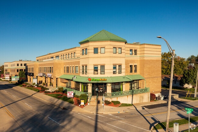
This Property Is For Sale
Current Lease Availabilities
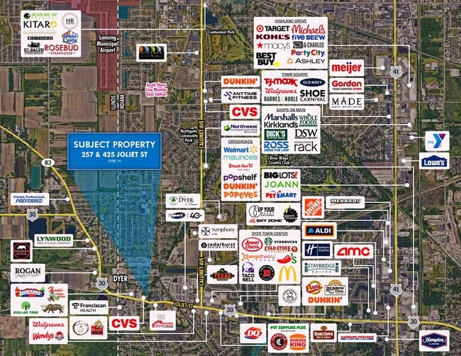
NEARBY LISTINGS FOR SALE OR LEASE
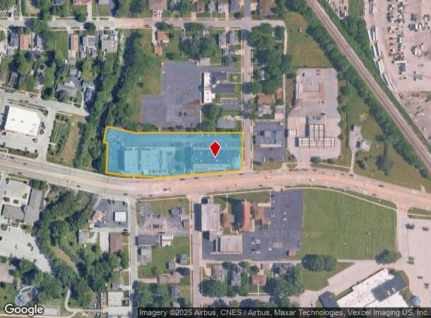
Property Detail
425 Joliet St
Chicago-Naperville-Elgin, IL-IN
The Galleria In Dyer Condominium
45-10-12-454-001.000-034
THE GALLERIA IN DYER CONDOMINIUM UNIT 116
Officebuilding
Lake
X
Indiana
17197C0385G
1
2024
0.98 AC
2025
Indiana
042803
Chicago
56,803 SF
DEMOGRAPHICS near 425 Joliet St
1 Mile
3 Mile
5 Mile
2024 Total Population
7,141
47,622
126,983
2029 Population
7,065
47,201
125,743
Pop Growth 2024-2029
(1.06%)
(0.88%)
(0.98%)
Average Age
42
42
43
2024 Total Households
2,711
18,272
49,208
HH Growth 2024-2029
(1.11%)
(0.99%)
(1.10%)
Median Household Inc
$86,388
$81,854
$84,695
Avg Household Size
2.60
2.50
2.50
2024 Avg HH Vehicles
2.00
2.00
2.00
Median Home Value
$246,071
$257,037
$247,489
Median Year Built
1984
1987
1979
Nearby Places
Map Layers
Map Styles
 Street
 Aerial
- Restaurants
- Banks
- Shops
- Fitness
- Groceries
PUBLIC TRANSPORTATION
AIRPORT
Chicago Midway International
DRIVE
WALK
Distance
Chicago Midway International
49 min
37.5 mi
Freight Ports
Port of Baltimore
DRIVE
WALK
Distance
Port of Baltimore
1 min
594.7 mi
Nearby Properties
Address
Land Use
TOTAL SIZE
Lot Size
Zoning
Address
Land Use
TOTAL SIZE
Lot Size
Zoning
552,813 SF
26.48 AC
Address
Land Use
TOTAL SIZE
Lot Size
Zoning
296,588 SF
36.83 AC
R33
Address
Land Use
TOTAL SIZE
Lot Size
Zoning
143,274 SF
17.90 AC
1116
Address
Land Use
TOTAL SIZE
Lot Size
Zoning
130,558 SF
9.89 AC
R33
Address
Land Use
TOTAL SIZE
Lot Size
Zoning
81,622 SF
9.20 AC
Address
Land Use
TOTAL SIZE
Lot Size
Zoning
246,302 SF
13.08 AC
Address
Land Use
TOTAL SIZE
Lot Size
Zoning
90,526 SF
22.99 AC
R33
Address
Land Use
TOTAL SIZE
Lot Size
Zoning
64,855 SF
5 AC
Address
Land Use
TOTAL SIZE
Lot Size
Zoning
70,017 SF
11 AC
R33
Address
Land Use
TOTAL SIZE
Lot Size
Zoning
87,836 SF
14.12 AC
R33
Address
Land Use
TOTAL SIZE
Lot Size
Zoning
134,623 SF
7.08 AC
Address
Land Use
TOTAL SIZE
Lot Size
Zoning
62,026 SF
9.70 AC
Address
Land Use
TOTAL SIZE
Lot Size
Zoning
66,240 SF
0.45 AC
Address
Land Use
TOTAL SIZE
Lot Size
Zoning
176,859 SF
12.01 AC
R33
Address
Land Use
TOTAL SIZE
Lot Size
Zoning
25,910 SF
2.06 AC
Address
Land Use
TOTAL SIZE
Lot Size
Zoning
60,992 SF
11.38 AC
R33
Address
Land Use
TOTAL SIZE
Lot Size
Zoning
63,711 SF
6.98 AC
Address
Land Use
TOTAL SIZE
Lot Size
Zoning
158,292 SF
8.20 AC
Address
Land Use
TOTAL SIZE
Lot Size
Zoning
129,320 SF
3.96 AC
Address
Land Use
TOTAL SIZE
Lot Size
Zoning
134,080 SF
10 AC
Address
Land Use
TOTAL SIZE
Lot Size
Zoning
78,221 SF
6.37 AC
Address
Land Use
TOTAL SIZE
Lot Size
Zoning
119,758 SF
3.80 AC
Address
Land Use
TOTAL SIZE
Lot Size
Zoning
156,258 SF
4.80 AC
Address
Land Use
TOTAL SIZE
Lot Size
Zoning
39,814 SF
2.49 AC
Address
Land Use
TOTAL SIZE
Lot Size
Zoning
123,693 SF
12.45 AC
Address
Land Use
TOTAL SIZE
Lot Size
Zoning
148,851 SF
20.81 AC
Address
Land Use
TOTAL SIZE
Lot Size
Zoning
35,471 SF
6.90 AC
R33
Address
Land Use
TOTAL SIZE
Lot Size
Zoning
25,773 SF
3 AC
Address
Land Use
TOTAL SIZE
Lot Size
Zoning
27,530 SF
2.34 AC
Address
Land Use
TOTAL SIZE
Lot Size
Zoning
21,566 SF
25.76 AC
The World's #1 Commercial Real Estate Marketplace
Connect with us
© 2026 CoStar Group
The information above has been obtained from sources believed reliable. While we do not doubt its accuracy we have not verified it and make no guarantee, warranty or representation about it. It is your responsibility to independently confirm its accuracy and completeness. Any projections, opinions, assumptions, or estimates used are for example only and do not represent the current or future performance of the property. The value of this transaction to you depends on tax and other factors which should be evaluated by your tax, financial, and legal advisors. You and your advisors should conduct a careful, independent investigation of the property to determine to your satisfaction the suitability of the property for your needs.