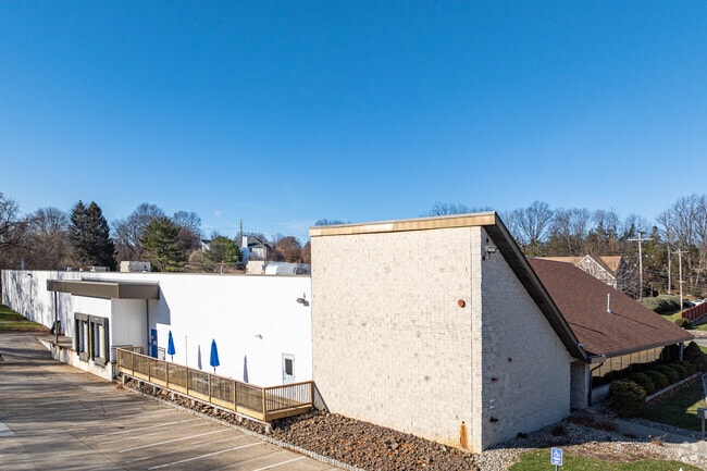
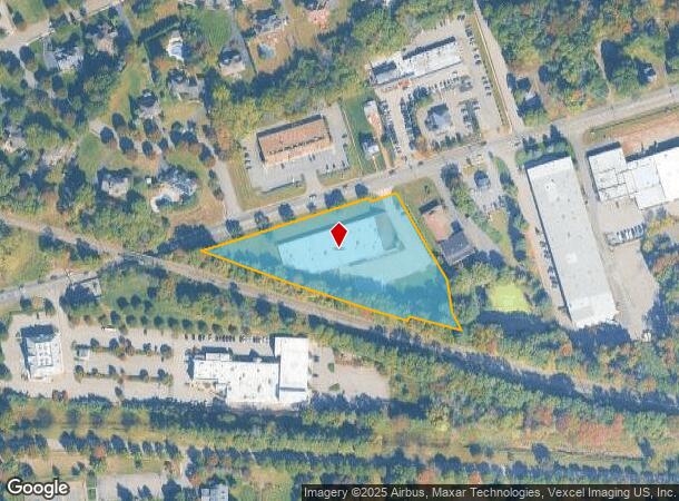
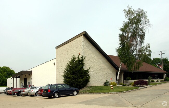
Property Record
425 Route 202, Towaco, NJ 07082
NEARBY LISTINGS FOR SALE OR LEASE
Property Detail
425 Route 202
Newark, NJ-PA
Morris
21-00081-0000-00001
New Jersey
Industrialgeneral
1
2024
2.75 AC
2025
Eastern Morris
040801
Northern New Jersey
27,606 SF
DEMOGRAPHICS near 425 Route 202
1 Mile
3 Mile
5 Mile
2024 Total Population
4,408
39,126
107,798
2029 Population
4,394
38,856
107,770
Pop Growth 2024-2029
(0.32%)
(0.69%)
(0.03%)
Average Age
44
43
43
2024 Total Households
1,586
14,310
40,204
HH Growth 2024-2029
(0.38%)
(0.73%)
(0.02%)
Median Household Inc
$137,323
$116,036
$114,695
Avg Household Size
2.80
2.60
2.60
2024 Avg HH Vehicles
2.00
2.00
2.00
Median Home Value
$653,416
$515,766
$540,337
Median Year Built
1981
1969
1968
Nearby Places
Map Layers
Map Styles
 Street
 Aerial
- Restaurants
- Banks
- Shops
- Fitness
- Groceries
PUBLIC TRANSPORTATION
TRANSIT/SUBWAY
Towaco (Montclair-Boonton Line - NJ Transit Commuter Rail (NJ Transit))
DRIVE
WALK
Distance
Towaco (Montclair-Boonton Line - NJ Transit Commuter Rail (NJ Transit))
2 min
19 min
1.0 mi
COMMUTER RAIL
Towaco (Montclair-Boonton Line - NJ Transit Commuter Rail (NJ Transit))
DRIVE
WALK
Distance
Towaco (Montclair-Boonton Line - NJ Transit Commuter Rail (NJ Transit))
2 min
19 min
1.0 mi
Boonton (Montclair-Boonton Line - NJ Transit Commuter Rail (NJ Transit))
DRIVE
WALK
Distance
Boonton (Montclair-Boonton Line - NJ Transit Commuter Rail (NJ Transit))
6 min
3.1 mi
AIRPORT
Newark Liberty International
DRIVE
WALK
Distance
Newark Liberty International
36 min
28.2 mi
LaGuardia
DRIVE
WALK
Distance
LaGuardia
52 min
36.1 mi
Freight Ports
Maher Terminal
DRIVE
WALK
Distance
Maher Terminal
43 min
28.0 mi
SALE & LEASE HISTORY
LISTING DATE
SALE/LEASE

Nov 14, 2022
For Lease
Nearby Properties
Address
Land Use
TOTAL SIZE
Lot Size
Zoning
Address
Land Use
TOTAL SIZE
Lot Size
Zoning
98,228 SF
16.66 AC
I-1
Address
Land Use
TOTAL SIZE
Lot Size
Zoning
5,880 SF
17.46 AC
I
Address
Land Use
TOTAL SIZE
Lot Size
Zoning
140,560 SF
49.81 AC
R27A
Address
Land Use
TOTAL SIZE
Lot Size
Zoning
4,172 SF
338 AC
R-1
Address
Land Use
TOTAL SIZE
Lot Size
Zoning
192,206 SF
7.73 AC
R-20
Address
Land Use
TOTAL SIZE
Lot Size
Zoning
132,411 SF
24.87 AC
B-5
Address
Land Use
TOTAL SIZE
Lot Size
Zoning
4.99 AC
OB
Address
Land Use
TOTAL SIZE
Lot Size
Zoning
97,631 SF
10.01 AC
B-2
Address
Land Use
TOTAL SIZE
Lot Size
Zoning
Address
Land Use
TOTAL SIZE
Lot Size
Zoning
47,312 SF
12.34 AC
R-20
Address
Land Use
TOTAL SIZE
Lot Size
Zoning
50,948 SF
5.60 AC
C-1
Address
Land Use
TOTAL SIZE
Lot Size
Zoning
77,992 SF
9.87 AC
OB1
Address
Land Use
TOTAL SIZE
Lot Size
Zoning
44,390 SF
2.06 AC
I-2
Address
Land Use
TOTAL SIZE
Lot Size
Zoning
88,819 SF
80.33 AC
R-1A
Address
Land Use
TOTAL SIZE
Lot Size
Zoning
76,160 SF
12.83 AC
I2
Address
Land Use
TOTAL SIZE
Lot Size
Zoning
79,950 SF
33.01 AC
I2
Address
Land Use
TOTAL SIZE
Lot Size
Zoning
114,540 SF
2.57 AC
OB2B
Address
Land Use
TOTAL SIZE
Lot Size
Zoning
25,266 SF
20.40 AC
R27A
Address
Land Use
TOTAL SIZE
Lot Size
Zoning
122,022 SF
19.09 AC
R-2A
Address
Land Use
TOTAL SIZE
Lot Size
Zoning
2.22 AC
OB-2
Address
Land Use
TOTAL SIZE
Lot Size
Zoning
1,434 SF
6.10 AC
I
Address
Land Use
TOTAL SIZE
Lot Size
Zoning
35,226 SF
11.82 AC
R-15
Address
Land Use
TOTAL SIZE
Lot Size
Zoning
21,048 SF
2.24 AC
R-15
Address
Land Use
TOTAL SIZE
Lot Size
Zoning
54,944 SF
4.89 AC
I
Address
Land Use
TOTAL SIZE
Lot Size
Zoning
91,880 SF
24.54 AC
I2
Address
Land Use
TOTAL SIZE
Lot Size
Zoning
44,440 SF
1.42 AC
R40
Address
Land Use
TOTAL SIZE
Lot Size
Zoning
18,352 SF
4.19 AC
OB2A
Address
Land Use
TOTAL SIZE
Lot Size
Zoning
44.61 AC
I1A
Address
Land Use
TOTAL SIZE
Lot Size
Zoning
9.90 AC
R43
Address
Land Use
TOTAL SIZE
Lot Size
Zoning
43,862 SF
4.01 AC
TI
The World's #1 Commercial Real Estate Marketplace
Connect with us
© 2025 CoStar Group
The information above has been obtained from sources believed reliable. While we do not doubt its accuracy we have not verified it and make no guarantee, warranty or representation about it. It is your responsibility to independently confirm its accuracy and completeness. Any projections, opinions, assumptions, or estimates used are for example only and do not represent the current or future performance of the property. The value of this transaction to you depends on tax and other factors which should be evaluated by your tax, financial, and legal advisors. You and your advisors should conduct a careful, independent investigation of the property to determine to your satisfaction the suitability of the property for your needs.