Property Record
425 Mount Zion Church Rd, Lagrange, GA 30241

NEARBY LISTINGS FOR SALE OR LEASE
Property Detail
425 Mount Zion Church Rd
LaGrange, GA
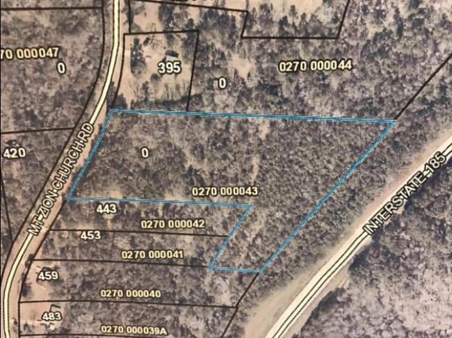
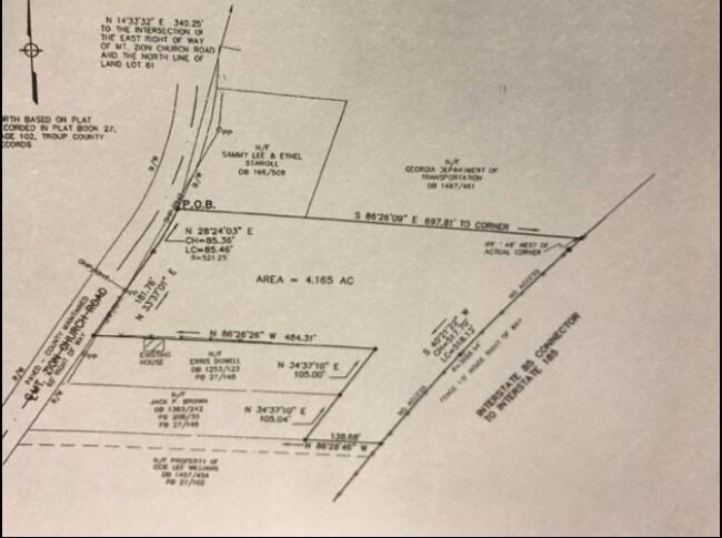
Mt Zion Church Road
027-0-000-043
425 MT ZION CHURCH RD/ TR-2
Residentialacreage
Troup
X
Georgia
13285C0154E
61
2024
2.06 AC
2024
Troup County
960504
Columbus GA
DEMOGRAPHICS near 425 Mount Zion Church Rd
1 Mile
3 Mile
5 Mile
2024 Total Population
510
4,659
19,415
2029 Population
526
4,773
19,824
Pop Growth 2024-2029
+ 3.14%
+ 2.45%
+ 2.11%
Average Age
40
39
38
2024 Total Households
182
1,783
7,357
HH Growth 2024-2029
+ 3.85%
+ 2.52%
+ 2.13%
Median Household Inc
$56,785
$49,191
$48,807
Avg Household Size
2.70
2.60
2.60
2024 Avg HH Vehicles
2.00
2.00
2.00
Median Home Value
$158,823
$176,444
$160,706
Median Year Built
1992
1989
1987
Nearby Places
Map Layers
Map Styles
 Street
 Aerial
- Restaurants
- Banks
- Shops
- Fitness
- Groceries
SALE & LEASE HISTORY
LISTING DATE
SALE/LEASE

Jul 12, 2017
For Sale
Nearby Properties
Address
Land Use
TOTAL SIZE
Lot Size
Zoning
Address
Land Use
TOTAL SIZE
Lot Size
Zoning
845,961 SF
214.16 AC
16- CP-GI
Address
Land Use
TOTAL SIZE
Lot Size
Zoning
191,357 SF
89.77 AC
01-SFMD
Address
Land Use
TOTAL SIZE
Lot Size
Zoning
2,152 SF
21.70 AC
16- CR-MR
Address
Land Use
TOTAL SIZE
Lot Size
Zoning
117,684 SF
12.61 AC
16- AC-MX
Address
Land Use
TOTAL SIZE
Lot Size
Zoning
190,149 SF
20.67 AC
16- CP-GI
Address
Land Use
TOTAL SIZE
Lot Size
Zoning
136,640 SF
41.91 AC
16- CP-GI
Address
Land Use
TOTAL SIZE
Lot Size
Zoning
8,448 SF
25.78 AC
16- CR-MX
Address
Land Use
TOTAL SIZE
Lot Size
Zoning
202,500 SF
17.55 AC
16- CP-GI
Address
Land Use
TOTAL SIZE
Lot Size
Zoning
125,467 SF
35.19 AC
16- CR-MX
Address
Land Use
TOTAL SIZE
Lot Size
Zoning
34,380 SF
59.74 AC
16- CR-MX
Address
Land Use
TOTAL SIZE
Lot Size
Zoning
84,400 SF
23.54 AC
16- CP-GI
Address
Land Use
TOTAL SIZE
Lot Size
Zoning
56,992 SF
4.44 AC
16- CR-MX
Address
Land Use
TOTAL SIZE
Lot Size
Zoning
38,947 SF
9.57 AC
16- CP-GI
Address
Land Use
TOTAL SIZE
Lot Size
Zoning
1,817.28 AC
01-SFMD
Address
Land Use
TOTAL SIZE
Lot Size
Zoning
35,512 SF
2.64 AC
16- CR-MX
Address
Land Use
TOTAL SIZE
Lot Size
Zoning
76,080 SF
25 AC
16- CP-GI
Address
Land Use
TOTAL SIZE
Lot Size
Zoning
108,000 SF
14.90 AC
16- CR-MX
Address
Land Use
TOTAL SIZE
Lot Size
Zoning
41,396 SF
1.50 AC
16- CR-MX
Address
Land Use
TOTAL SIZE
Lot Size
Zoning
27,825 SF
1.02 AC
16- CR-MX
Address
Land Use
TOTAL SIZE
Lot Size
Zoning
53,342 SF
1.22 AC
16- CR-MX
Address
Land Use
TOTAL SIZE
Lot Size
Zoning
52,196 SF
1.06 AC
16- CR-MX
Address
Land Use
TOTAL SIZE
Lot Size
Zoning
9,060 SF
5.49 AC
16- CR-MX
Address
Land Use
TOTAL SIZE
Lot Size
Zoning
39,600 SF
1.84 AC
16- CR-MX
Address
Land Use
TOTAL SIZE
Lot Size
Zoning
255,283 SF
25.32 AC
16- CR-MX
Address
Land Use
TOTAL SIZE
Lot Size
Zoning
18,926 SF
3.85 AC
16- CR-MX
Address
Land Use
TOTAL SIZE
Lot Size
Zoning
7,276 SF
0.11 AC
16- CR-MX
Address
Land Use
TOTAL SIZE
Lot Size
Zoning
108.12 AC
16- AC-MX
Address
Land Use
TOTAL SIZE
Lot Size
Zoning
13,968 SF
1.44 AC
16- CR-MX
Address
Land Use
TOTAL SIZE
Lot Size
Zoning
37,496 SF
3.68 AC
16- CR-MX
Address
Land Use
TOTAL SIZE
Lot Size
Zoning
34,707 SF
4.59 AC
16- CR-MX
The World's #1 Commercial Real Estate Marketplace
Connect with us
© 2025 CoStar Group
The information above has been obtained from sources believed reliable. While we do not doubt its accuracy we have not verified it and make no guarantee, warranty or representation about it. It is your responsibility to independently confirm its accuracy and completeness. Any projections, opinions, assumptions, or estimates used are for example only and do not represent the current or future performance of the property. The value of this transaction to you depends on tax and other factors which should be evaluated by your tax, financial, and legal advisors. You and your advisors should conduct a careful, independent investigation of the property to determine to your satisfaction the suitability of the property for your needs.